Fisher County Sketch File Bb
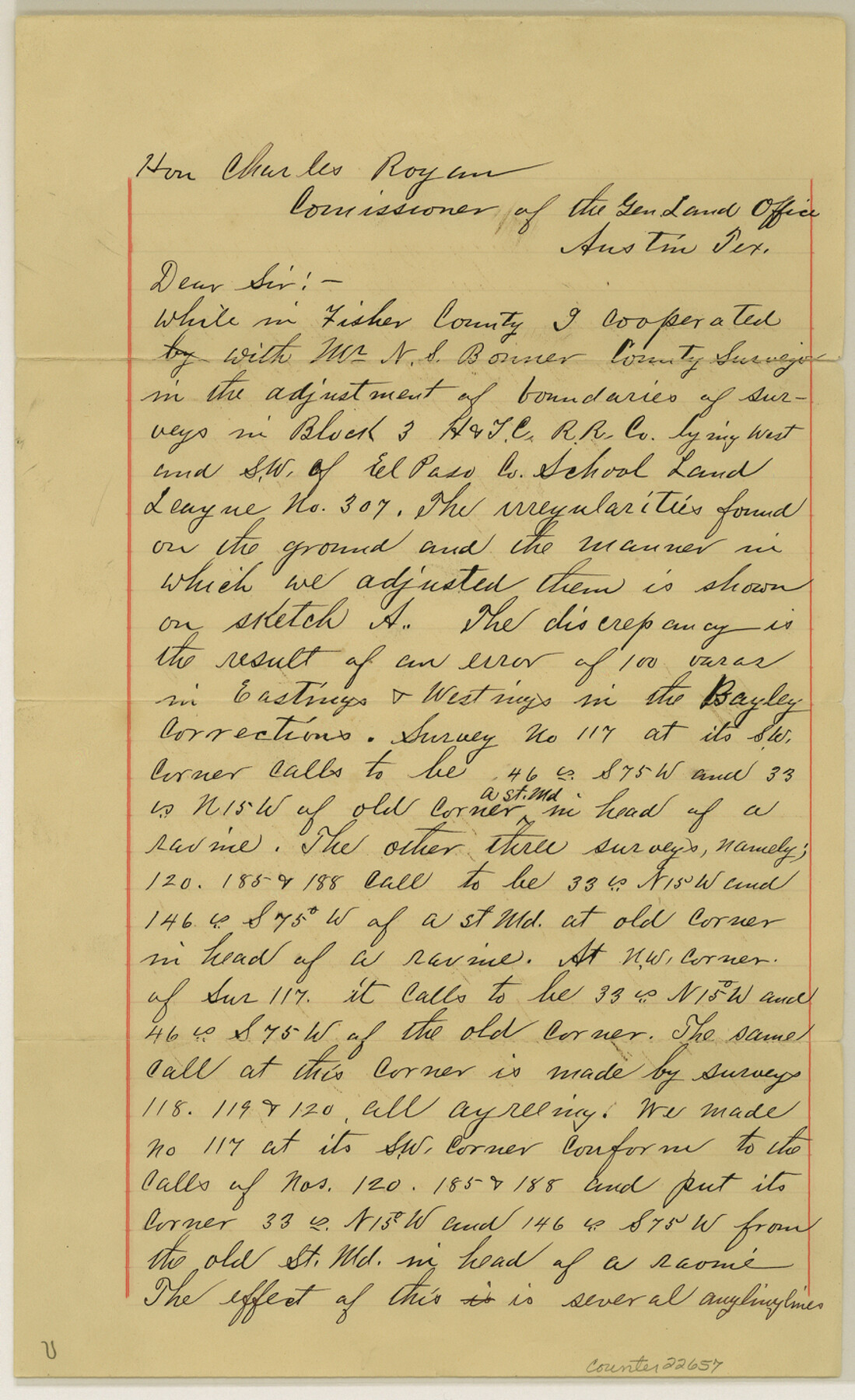
[Surveyor's report and sketch regarding surveys in H. & T. C. R.R. Co. Block 3 and County School Land leagues south and west from Roby]
-
Map/Doc
22657
-
Collection
General Map Collection
-
Object Dates
1/10/1902 (Creation Date)
1/15/1902 (File Date)
-
People and Organizations
George M. Williams (Surveyor/Engineer)
-
Counties
Fisher
-
Subjects
Surveying Sketch File
-
Height x Width
14.3 x 8.7 inches
36.3 x 22.1 cm
-
Medium
paper, manuscript
-
Features
Elm Fork [of the Brazos River]
Cottonwood Creek
Part of: General Map Collection
[Right of Way & Track Map, The Texas & Pacific Ry. Co. Main Line]
![64670, [Right of Way & Track Map, The Texas & Pacific Ry. Co. Main Line], General Map Collection](https://historictexasmaps.com/wmedia_w700/maps/64670.tif.jpg)
Print $20.00
- Digital $50.00
[Right of Way & Track Map, The Texas & Pacific Ry. Co. Main Line]
Size 11.0 x 18.5 inches
Map/Doc 64670
Map of University Land being a part of Block L, El Paso County, Texas

Print $20.00
- Digital $50.00
Map of University Land being a part of Block L, El Paso County, Texas
1945
Size 26.1 x 25.8 inches
Map/Doc 2423
Goliad County Working Sketch 2

Print $20.00
- Digital $50.00
Goliad County Working Sketch 2
1916
Size 15.5 x 21.6 inches
Map/Doc 63192
Map of the Interior of Louisiana with a part of New Mexico

Print $20.00
- Digital $50.00
Map of the Interior of Louisiana with a part of New Mexico
1813
Size 11.9 x 15.7 inches
Map/Doc 94460
Johnson County Sketch File 15

Print $2.00
- Digital $50.00
Johnson County Sketch File 15
1881
Size 8.1 x 7.3 inches
Map/Doc 28455
Lynn County Boundary File 1

Print $10.00
- Digital $50.00
Lynn County Boundary File 1
Size 14.2 x 8.7 inches
Map/Doc 56617
Flight Mission No. DIX-8P, Frame 86, Aransas County

Print $20.00
- Digital $50.00
Flight Mission No. DIX-8P, Frame 86, Aransas County
1956
Size 18.4 x 22.3 inches
Map/Doc 83911
La Salle County Sketch File 43

Print $20.00
- Digital $50.00
La Salle County Sketch File 43
1937
Size 18.7 x 28.4 inches
Map/Doc 11988
Stephens County Boundary File 3

Print $25.00
- Digital $50.00
Stephens County Boundary File 3
Size 14.2 x 8.8 inches
Map/Doc 58882
Hall County Working Sketch 1

Print $20.00
- Digital $50.00
Hall County Working Sketch 1
Size 19.5 x 18.0 inches
Map/Doc 63329
Presidio County Sketch File 62

Print $10.00
- Digital $50.00
Presidio County Sketch File 62
1938
Size 11.2 x 8.8 inches
Map/Doc 34647
Brewster County Rolled Sketch 114

Print $20.00
- Digital $50.00
Brewster County Rolled Sketch 114
1964
Size 11.6 x 17.3 inches
Map/Doc 5273
You may also like
Harrison County State Real Property Sketch 1

Print $20.00
- Digital $50.00
Harrison County State Real Property Sketch 1
1986
Size 24.2 x 25.4 inches
Map/Doc 61666
Kaufman County Boundary File 6

Print $14.00
- Digital $50.00
Kaufman County Boundary File 6
Size 11.2 x 8.7 inches
Map/Doc 55956
Hidalgo County Sketch File 6

Print $4.00
- Digital $50.00
Hidalgo County Sketch File 6
1891
Size 10.3 x 8.4 inches
Map/Doc 26403
Hale County Rolled Sketch 5

Print $20.00
- Digital $50.00
Hale County Rolled Sketch 5
1893
Size 29.0 x 22.2 inches
Map/Doc 9094
[Sketch for Mineral Application 16696-16697, Pecos River]
![65612, [Sketch for Mineral Application 16696-16697, Pecos River], General Map Collection](https://historictexasmaps.com/wmedia_w700/maps/65612-1.tif.jpg)
Print $40.00
- Digital $50.00
[Sketch for Mineral Application 16696-16697, Pecos River]
Size 37.4 x 74.9 inches
Map/Doc 65612
Cameron County Rolled Sketch 26

Print $20.00
- Digital $50.00
Cameron County Rolled Sketch 26
Size 18.5 x 24.3 inches
Map/Doc 5390
Jack County Sketch File 10

Print $4.00
- Digital $50.00
Jack County Sketch File 10
1857
Size 12.4 x 8.3 inches
Map/Doc 27527
Jim Wells County Working Sketch 13

Print $20.00
- Digital $50.00
Jim Wells County Working Sketch 13
1980
Size 36.7 x 26.3 inches
Map/Doc 66611
Hamilton County Boundary File 2

Print $4.00
- Digital $50.00
Hamilton County Boundary File 2
Size 14.2 x 8.8 inches
Map/Doc 54195
Stonewall County Working Sketch 21

Print $20.00
- Digital $50.00
Stonewall County Working Sketch 21
1961
Size 30.4 x 26.8 inches
Map/Doc 62328
Hemphill County Rolled Sketch 16

Print $40.00
- Digital $50.00
Hemphill County Rolled Sketch 16
1961
Size 65.4 x 26.9 inches
Map/Doc 9156
Dawson County Sketch File 1

Print $6.00
- Digital $50.00
Dawson County Sketch File 1
Size 7.5 x 3.9 inches
Map/Doc 20495