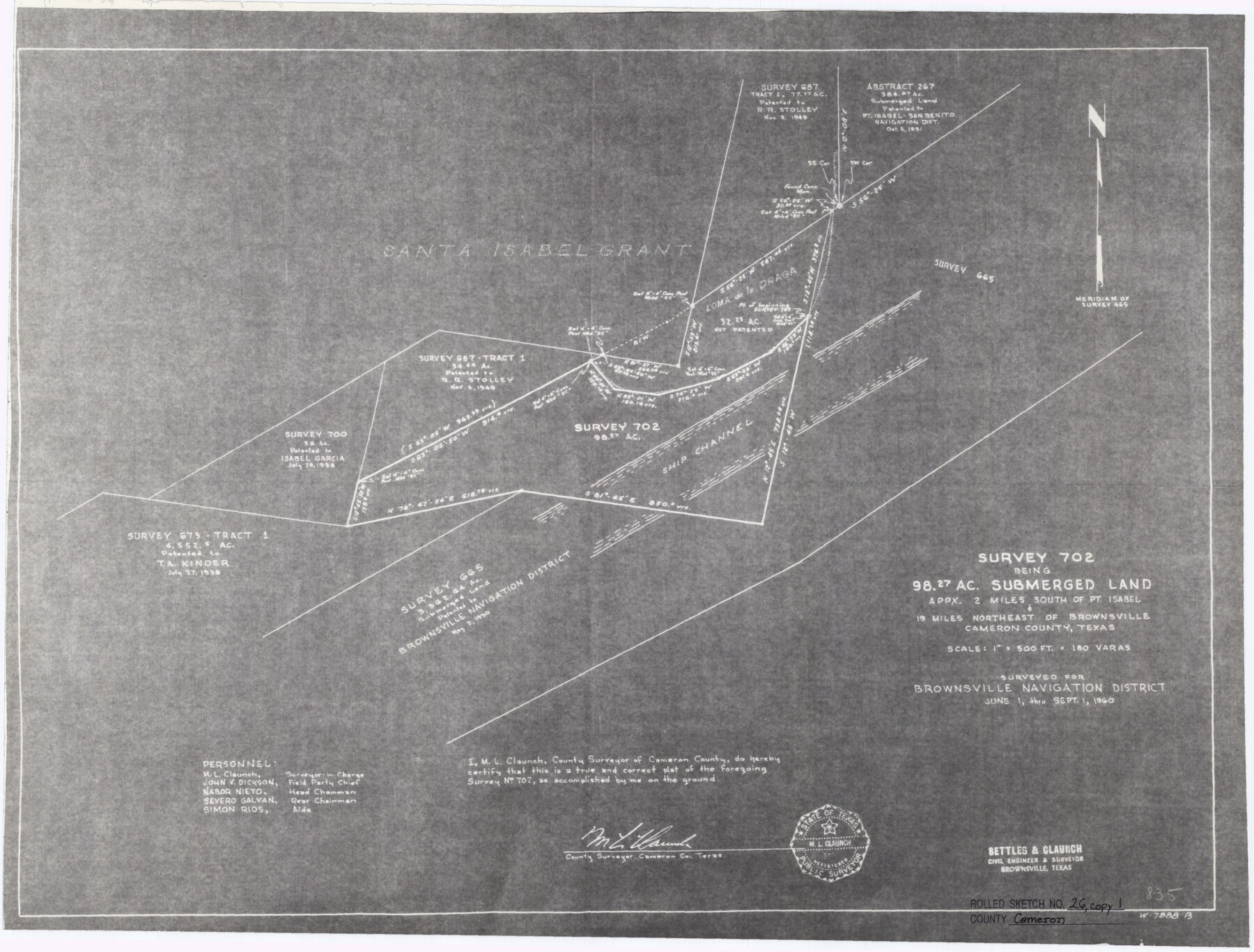
Cameron County Rolled Sketch 26
Survey 702 being 98.27 ac. submerged land appx. 2 miles south of Pt. Isabel & 19 miles northeast of Brownsville
-
Map/Doc
5390
-
Collection
General Map Collection
-
Object Dates
1960/9/1 (Survey Date)
1984/1/6 (File Date)
-
People and Organizations
M.L. Claunch (Surveyor/Engineer)
John V. Dickson (Chainman/Field Personnel)
Nabor Nieto (Chainman/Field Personnel)
Severo Galvan (Chainman/Field Personnel)
Simon Rios (Chainman/Field Personnel)
-
Counties
Cameron
-
Subjects
Surveying Rolled Sketch
-
Height x Width
18.5 x 24.3 inches
47.0 x 61.7 cm
-
Medium
paper, photocopy
-
Scale
1" = 500 feet = 180 varas
-
Comments
For office use only. Copy 1 of 2.
Part of: General Map Collection
Lipscomb County Boundary File 8

Print $4.00
- Digital $50.00
Lipscomb County Boundary File 8
Size 11.1 x 8.6 inches
Map/Doc 56333
Gaines County Rolled Sketch 33

Print $20.00
- Digital $50.00
Gaines County Rolled Sketch 33
1995
Size 17.4 x 18.2 inches
Map/Doc 76413
Located Line of the Panhandle & Gulf Ry. through State Lands

Print $40.00
- Digital $50.00
Located Line of the Panhandle & Gulf Ry. through State Lands
1904
Size 12.4 x 78.0 inches
Map/Doc 64104
Brazoria County Working Sketch 29

Print $20.00
- Digital $50.00
Brazoria County Working Sketch 29
1971
Size 30.6 x 28.3 inches
Map/Doc 67514
El Paso County State Real Property Sketch 2

Print $20.00
- Digital $50.00
El Paso County State Real Property Sketch 2
2007
Size 24.4 x 36.2 inches
Map/Doc 88671
Martin County Sketch File 15

Print $4.00
- Digital $50.00
Martin County Sketch File 15
Size 11.9 x 8.3 inches
Map/Doc 30674
Kerr County Working Sketch 36

Print $20.00
- Digital $50.00
Kerr County Working Sketch 36
1991
Size 32.8 x 35.8 inches
Map/Doc 70067
Nueces County Rolled Sketch 53

Print $63.00
- Digital $50.00
Nueces County Rolled Sketch 53
1978
Size 10.1 x 15.1 inches
Map/Doc 47862
Van Zandt County Working Sketch 8

Print $3.00
- Digital $50.00
Van Zandt County Working Sketch 8
1982
Size 15.6 x 9.2 inches
Map/Doc 72258
Webb County Sketch File 5

Print $8.00
- Digital $50.00
Webb County Sketch File 5
1876
Size 12.8 x 8.1 inches
Map/Doc 39725
Cooke County Boundary File 1

Print $4.00
- Digital $50.00
Cooke County Boundary File 1
Size 12.6 x 7.5 inches
Map/Doc 51826
Dimmit County Rolled Sketch 11

Print $20.00
- Digital $50.00
Dimmit County Rolled Sketch 11
1942
Size 21.8 x 28.9 inches
Map/Doc 5720
You may also like
[School Land Leagues in east part of Bailey County/west part of Lamb County]
![90256, [School Land Leagues in east part of Bailey County/west part of Lamb County], Twichell Survey Records](https://historictexasmaps.com/wmedia_w700/maps/90256-1.tif.jpg)
Print $2.00
- Digital $50.00
[School Land Leagues in east part of Bailey County/west part of Lamb County]
Size 11.8 x 8.9 inches
Map/Doc 90256
Galveston County NRC Article 33.136 Sketch 46

Print $23.00
- Digital $50.00
Galveston County NRC Article 33.136 Sketch 46
2007
Size 24.6 x 36.0 inches
Map/Doc 87936
Potter County Boundary File 5

Print $24.00
- Digital $50.00
Potter County Boundary File 5
Size 15.0 x 9.4 inches
Map/Doc 58013
Fort Bend County State Real Property Sketch 11

Print $40.00
- Digital $50.00
Fort Bend County State Real Property Sketch 11
1986
Size 34.6 x 43.2 inches
Map/Doc 61685
Colorado County Sketch File 10

Print $48.00
- Digital $50.00
Colorado County Sketch File 10
1872
Size 9.2 x 7.9 inches
Map/Doc 18929
Sutton County Working Sketch 2

Print $20.00
- Digital $50.00
Sutton County Working Sketch 2
1968
Size 31.2 x 29.3 inches
Map/Doc 62345
A New Map of Texas

Print $20.00
- Digital $50.00
A New Map of Texas
1841
Size 17.6 x 16.2 inches
Map/Doc 93862

Mississippi River to Galveston

Print $40.00
- Digital $50.00
Mississippi River to Galveston
1986
Size 36.8 x 49.9 inches
Map/Doc 69948
Tracing From [Melish's] Map with Kansas and the Panhandle of Texas plotted thereon Showing the disputed Territory
![76190, Tracing From [Melish's] Map with Kansas and the Panhandle of Texas plotted thereon Showing the disputed Territory, Texas State Library and Archives](https://historictexasmaps.com/wmedia_w700/maps/76190.tif.jpg)
Print $20.00
Tracing From [Melish's] Map with Kansas and the Panhandle of Texas plotted thereon Showing the disputed Territory
1818
Size 18.8 x 19.8 inches
Map/Doc 76190
Flight Mission No. DQN-2K, Frame 91, Calhoun County

Print $20.00
- Digital $50.00
Flight Mission No. DQN-2K, Frame 91, Calhoun County
1953
Size 18.8 x 22.4 inches
Map/Doc 84281
Freestone County Working Sketch 6

Print $40.00
- Digital $50.00
Freestone County Working Sketch 6
1921
Size 38.3 x 60.0 inches
Map/Doc 69248