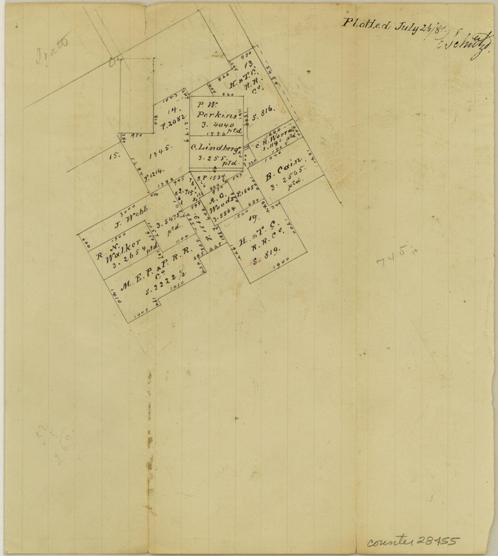
Johnson County Sketch File 15
[Sketch around the H. & T. C. RR. Co. surveys 13 and 14]
-
Map/Doc
28455
-
Collection
General Map Collection
-
Object Dates
7/26/1881 (Creation Date)
7/26/1881 (File Date)
-
People and Organizations
E. Schutze (Draftsman)
-
Counties
Johnson
-
Subjects
Surveying Sketch File
-
Height x Width
8.1 x 7.3 inches
20.6 x 18.5 cm
-
Medium
paper, manuscript
Part of: General Map Collection
Flight Mission No. DQN-1K, Frame 42, Calhoun County
![84142, Flight Mission No. DQN-1K, Frame 42, Calhoun County, General Map Collection](https://historictexasmaps.com/wmedia_w700/pdf_converted_jpg/qi_pdf_thumbnail_31359.jpg)
Print $20.00
- Digital $50.00
Flight Mission No. DQN-1K, Frame 42, Calhoun County
1953
Size 18.5 x 18.7 inches
Map/Doc 84142
Flight Mission No. BRA-6M, Frame 98, Jefferson County
![85441, Flight Mission No. BRA-6M, Frame 98, Jefferson County, General Map Collection](https://historictexasmaps.com/wmedia_w700/pdf_converted_jpg/qi_pdf_thumbnail_32641.jpg)
Print $20.00
- Digital $50.00
Flight Mission No. BRA-6M, Frame 98, Jefferson County
1953
Size 18.5 x 22.2 inches
Map/Doc 85441
Cooke County Rolled Sketch 2
![5561, Cooke County Rolled Sketch 2](https://historictexasmaps.com/wmedia_w700/maps/5561.tif.jpg)
Print $20.00
- Digital $50.00
Cooke County Rolled Sketch 2
1944
Size 29.4 x 28.1 inches
Map/Doc 5561
Panola County Rolled Sketch 4A
![10727, Panola County Rolled Sketch 4A, General Map Collection](https://historictexasmaps.com/wmedia_w700/maps/10727.tif.jpg)
Print $40.00
- Digital $50.00
Panola County Rolled Sketch 4A
1953
Size 50.7 x 26.1 inches
Map/Doc 10727
Frio County Sketch File 12
![23127, Frio County Sketch File 12, General Map Collection](https://historictexasmaps.com/wmedia_w700/pdf_converted_jpg/qi_pdf_thumbnail_11252.jpg)
Print $18.00
- Digital $50.00
Frio County Sketch File 12
1938
Size 14.2 x 8.7 inches
Map/Doc 23127
Flight Mission No. DIX-10P, Frame 71, Aransas County
![83932, Flight Mission No. DIX-10P, Frame 71, Aransas County, General Map Collection](https://historictexasmaps.com/wmedia_w700/pdf_converted_jpg/qi_pdf_thumbnail_31150.jpg)
Print $20.00
- Digital $50.00
Flight Mission No. DIX-10P, Frame 71, Aransas County
1956
Size 18.6 x 22.3 inches
Map/Doc 83932
County Map of the State of Texas Showing also portions of the Adjoining States and Territories (Inset: Plan of Galveston and Vicinity)
![93696, County Map of the State of Texas Showing also portions of the Adjoining States and Territories (Inset: Plan of Galveston and Vicinity), General Map Collection](https://historictexasmaps.com/wmedia_w700/maps/93696.tif.jpg)
Print $20.00
- Digital $50.00
County Map of the State of Texas Showing also portions of the Adjoining States and Territories (Inset: Plan of Galveston and Vicinity)
1873
Size 15.5 x 23.1 inches
Map/Doc 93696
Plan B, Part 3rd Shewing that portion of the boundary between Texas and the United States, included between Logan's Ferry on the River Sabine and the intersection of the 32nd degree of N. Latitude with the western bank of the said river
![65411, Plan B, Part 3rd Shewing that portion of the boundary between Texas and the United States, included between Logan's Ferry on the River Sabine and the intersection of the 32nd degree of N. Latitude with the western bank of the said river, General Map Collection](https://historictexasmaps.com/wmedia_w700/maps/65411.tif.jpg)
Print $20.00
- Digital $50.00
Plan B, Part 3rd Shewing that portion of the boundary between Texas and the United States, included between Logan's Ferry on the River Sabine and the intersection of the 32nd degree of N. Latitude with the western bank of the said river
1842
Size 19.4 x 27.2 inches
Map/Doc 65411
Controlled Mosaic by Jack Amman Photogrammetric Engineers, Inc - Sheet 13
![83457, Controlled Mosaic by Jack Amman Photogrammetric Engineers, Inc - Sheet 13, General Map Collection](https://historictexasmaps.com/wmedia_w700/maps/83457.tif.jpg)
Print $20.00
- Digital $50.00
Controlled Mosaic by Jack Amman Photogrammetric Engineers, Inc - Sheet 13
1954
Size 20.0 x 24.0 inches
Map/Doc 83457
Eastland County Working Sketch 39
![68820, Eastland County Working Sketch 39, General Map Collection](https://historictexasmaps.com/wmedia_w700/maps/68820.tif.jpg)
Print $20.00
- Digital $50.00
Eastland County Working Sketch 39
Size 43.0 x 37.4 inches
Map/Doc 68820
Lipscomb County
![3817, Lipscomb County, General Map Collection](https://historictexasmaps.com/wmedia_w700/maps/3817-1.tif.jpg)
Print $20.00
- Digital $50.00
Lipscomb County
1889
Size 23.5 x 18.5 inches
Map/Doc 3817
Flight Mission No. DIX-3P, Frame 167, Aransas County
![83773, Flight Mission No. DIX-3P, Frame 167, Aransas County, General Map Collection](https://historictexasmaps.com/wmedia_w700/pdf_converted_jpg/qi_pdf_thumbnail_30994.jpg)
Print $20.00
- Digital $50.00
Flight Mission No. DIX-3P, Frame 167, Aransas County
1956
Size 17.8 x 18.0 inches
Map/Doc 83773
You may also like
Traced from Genl. Arista's map captured by the American Army under Genl. Taylor at Resaca de la Palma 9th May '46 and presented to James K. Polk, President U. States
![73060, Traced from Genl. Arista's map captured by the American Army under Genl. Taylor at Resaca de la Palma 9th May '46 and presented to James K. Polk, President U. States, General Map Collection](https://historictexasmaps.com/wmedia_w700/maps/73060.tif.jpg)
Print $20.00
- Digital $50.00
Traced from Genl. Arista's map captured by the American Army under Genl. Taylor at Resaca de la Palma 9th May '46 and presented to James K. Polk, President U. States
1846
Size 18.2 x 27.3 inches
Map/Doc 73060
Sabine County
![16805, Sabine County, General Map Collection](https://historictexasmaps.com/wmedia_w700/maps/16805.tif.jpg)
Print $20.00
- Digital $50.00
Sabine County
1920
Size 44.6 x 35.1 inches
Map/Doc 16805
Sketch Showing Original Corners Affecting Block I and Adjacent Surveys from Actual Connections by W. D. Twichell
![90281, Sketch Showing Original Corners Affecting Block I and Adjacent Surveys from Actual Connections by W. D. Twichell, Twichell Survey Records](https://historictexasmaps.com/wmedia_w700/maps/90281-1.tif.jpg)
Print $20.00
- Digital $50.00
Sketch Showing Original Corners Affecting Block I and Adjacent Surveys from Actual Connections by W. D. Twichell
Size 23.4 x 24.3 inches
Map/Doc 90281
Frio County Sketch File 17
![23152, Frio County Sketch File 17, General Map Collection](https://historictexasmaps.com/wmedia_w700/pdf_converted_jpg/qi_pdf_thumbnail_11257.jpg)
Print $6.00
- Digital $50.00
Frio County Sketch File 17
1955
Size 14.3 x 8.7 inches
Map/Doc 23152
Van Zandt County Sketch File 13
![39402, Van Zandt County Sketch File 13, General Map Collection](https://historictexasmaps.com/wmedia_w700/pdf_converted_jpg/qi_pdf_thumbnail_14829.jpg)
Print $4.00
- Digital $50.00
Van Zandt County Sketch File 13
1858
Size 10.6 x 8.2 inches
Map/Doc 39402
General Highway Map. Detail of Cities and Towns in Jim Wells County, Texas. City Map of Alice, Jim Wells County, Texas
![79544, General Highway Map. Detail of Cities and Towns in Jim Wells County, Texas. City Map of Alice, Jim Wells County, Texas, Texas State Library and Archives](https://historictexasmaps.com/wmedia_w700/maps/79544.tif.jpg)
Print $20.00
General Highway Map. Detail of Cities and Towns in Jim Wells County, Texas. City Map of Alice, Jim Wells County, Texas
1961
Size 24.6 x 18.3 inches
Map/Doc 79544
El Paso County Working Sketch 32
![69054, El Paso County Working Sketch 32, General Map Collection](https://historictexasmaps.com/wmedia_w700/maps/69054.tif.jpg)
Print $20.00
- Digital $50.00
El Paso County Working Sketch 32
Size 40.2 x 38.3 inches
Map/Doc 69054
[Geological Map of the Great East Texas Oil Fields]
![94272, [Geological Map of the Great East Texas Oil Fields], General Map Collection](https://historictexasmaps.com/wmedia_w700/maps/94272.tif.jpg)
Print $20.00
- Digital $50.00
[Geological Map of the Great East Texas Oil Fields]
Size 22.4 x 11.7 inches
Map/Doc 94272
Collingsworth County Working Sketch Graphic Index
![76499, Collingsworth County Working Sketch Graphic Index, General Map Collection](https://historictexasmaps.com/wmedia_w700/maps/76499.tif.jpg)
Print $20.00
- Digital $50.00
Collingsworth County Working Sketch Graphic Index
1971
Size 41.0 x 34.8 inches
Map/Doc 76499
Aransas County NRC Article 33.136 Sketch 21
![](https://historictexasmaps.com/wmedia_w700/pdf_converted_jpg/qi_pdf_thumbnail_71126.jpg)
Print $138.00
Aransas County NRC Article 33.136 Sketch 21
2024
Map/Doc 97269
Gregg County Working Sketch 19
![63286, Gregg County Working Sketch 19, General Map Collection](https://historictexasmaps.com/wmedia_w700/maps/63286.tif.jpg)
Print $20.00
- Digital $50.00
Gregg County Working Sketch 19
Size 31.7 x 37.3 inches
Map/Doc 63286
Irion County Working Sketch 8
![66417, Irion County Working Sketch 8, General Map Collection](https://historictexasmaps.com/wmedia_w700/maps/66417.tif.jpg)
Print $20.00
- Digital $50.00
Irion County Working Sketch 8
Size 42.0 x 41.0 inches
Map/Doc 66417