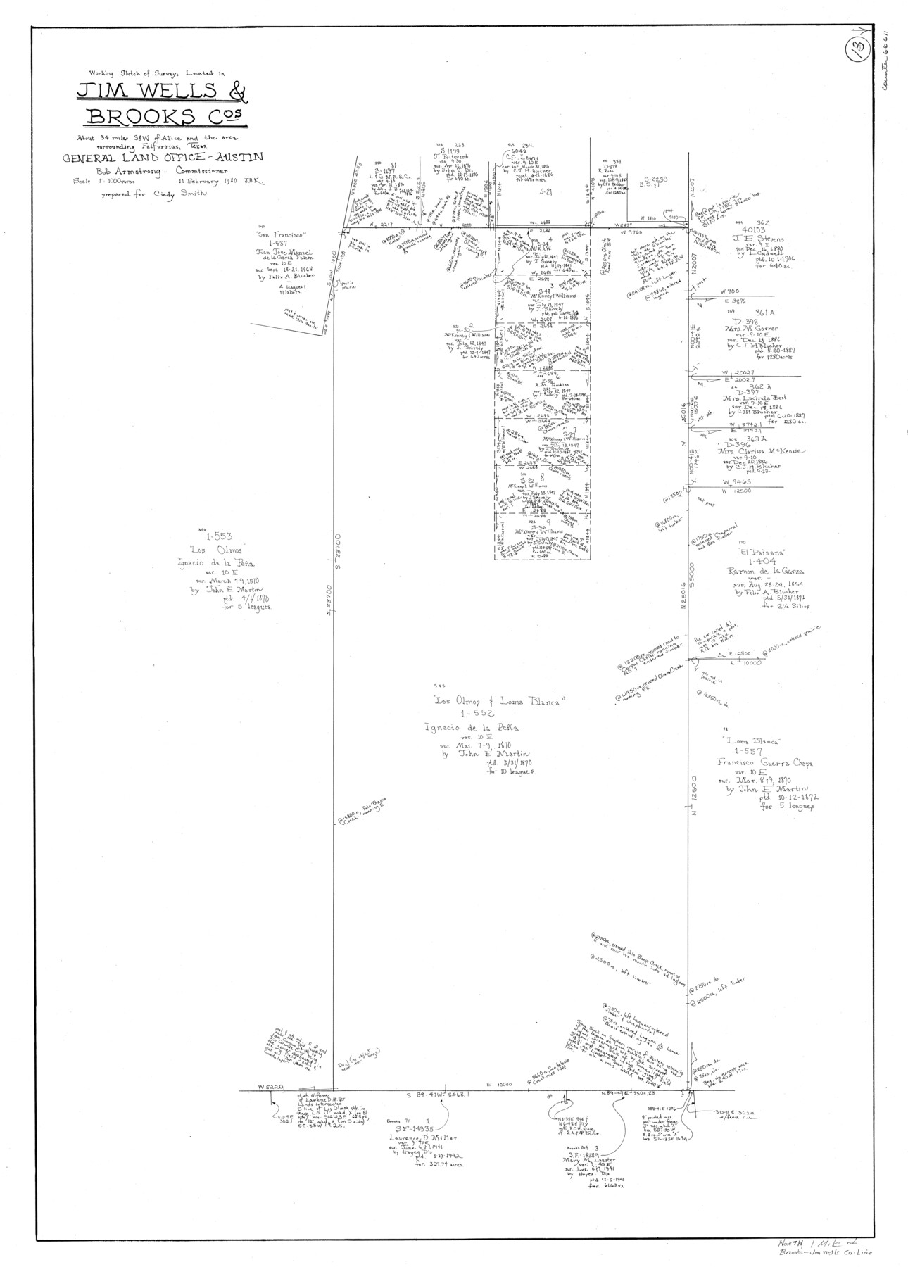
Jim Wells County Working Sketch 13
-
Map/Doc
66611
-
Collection
General Map Collection
-
Object Dates
2/11/1980 (Creation Date)
-
People and Organizations
Joan Kilpatrick (Draftsman)
-
Counties
Jim Wells Brooks
-
Subjects
Surveying Working Sketch
-
Height x Width
36.7 x 26.3 inches
93.2 x 66.8 cm
-
Scale
1" = 1000 varas
Part of: General Map Collection
Shackelford County Working Sketch 3

Print $20.00
- Digital $50.00
Shackelford County Working Sketch 3
1919
Size 23.2 x 17.5 inches
Map/Doc 63843
Blanco County Sketch File 26

Print $40.00
- Digital $50.00
Blanco County Sketch File 26
1888
Size 14.1 x 17.2 inches
Map/Doc 14618
Cherokee County Sketch File 7

Print $4.00
- Digital $50.00
Cherokee County Sketch File 7
Size 10.3 x 8.3 inches
Map/Doc 18128
Collin County Boundary File 18e

Print $16.00
- Digital $50.00
Collin County Boundary File 18e
Size 6.8 x 8.1 inches
Map/Doc 51749
Concho County Sketch File 24

Print $12.00
- Digital $50.00
Concho County Sketch File 24
1885
Size 11.1 x 8.4 inches
Map/Doc 19149
[Surveys East of river copied from U.S. map of Township No. 6 South, Range No. 9 West of the Indian Meridian, Oklahoma]
![75186, [Surveys East of river copied from U.S. map of Township No. 6 South, Range No. 9 West of the Indian Meridian, Oklahoma], General Map Collection](https://historictexasmaps.com/wmedia_w700/maps/75186.tif.jpg)
Print $2.00
- Digital $50.00
[Surveys East of river copied from U.S. map of Township No. 6 South, Range No. 9 West of the Indian Meridian, Oklahoma]
Size 13.3 x 9.2 inches
Map/Doc 75186
Wilbarger County Sketch File 4

Print $4.00
- Digital $50.00
Wilbarger County Sketch File 4
1883
Size 12.7 x 8.2 inches
Map/Doc 40168
Webb County Sketch File F

Print $6.00
- Digital $50.00
Webb County Sketch File F
1900
Size 10.7 x 15.1 inches
Map/Doc 39699
Origin of Imports and Destination of Exports at Galveston, Tex., during 1921

Print $20.00
- Digital $50.00
Origin of Imports and Destination of Exports at Galveston, Tex., during 1921
1921
Size 13.1 x 24.6 inches
Map/Doc 97169
Louisiana and Texas Intracoastal Waterway

Print $20.00
- Digital $50.00
Louisiana and Texas Intracoastal Waterway
1937
Size 13.7 x 19.6 inches
Map/Doc 83348

Red River County Working Sketch 69

Print $20.00
- Digital $50.00
Red River County Working Sketch 69
1975
Size 23.7 x 19.1 inches
Map/Doc 72052
You may also like
Under Sapphire Skies San Antonio

Under Sapphire Skies San Antonio
1928
Size 9.4 x 6.4 inches
Map/Doc 97043
Lipscomb County Boundary File 9

Print $8.00
- Digital $50.00
Lipscomb County Boundary File 9
Size 11.2 x 8.5 inches
Map/Doc 56335
Schleicher County Working Sketch 22

Print $20.00
- Digital $50.00
Schleicher County Working Sketch 22
1953
Size 26.2 x 15.3 inches
Map/Doc 63824
Terrell County Rolled Sketch 50

Print $20.00
- Digital $50.00
Terrell County Rolled Sketch 50
1963
Size 35.9 x 20.5 inches
Map/Doc 7967
Sketch on Ioni Creek

Print $2.00
- Digital $50.00
Sketch on Ioni Creek
1846
Size 9.1 x 6.4 inches
Map/Doc 134
Rockwall County

Print $20.00
- Digital $50.00
Rockwall County
1941
Size 26.0 x 21.3 inches
Map/Doc 77410
Kimble County Rolled Sketch 38

Print $20.00
- Digital $50.00
Kimble County Rolled Sketch 38
1986
Size 28.3 x 21.7 inches
Map/Doc 6528
[Surveys near the Guadalupe River]
![288, [Surveys near the Guadalupe River], General Map Collection](https://historictexasmaps.com/wmedia_w700/maps/288.tif.jpg)
Print $2.00
- Digital $50.00
[Surveys near the Guadalupe River]
1847
Size 8.8 x 7.9 inches
Map/Doc 288
Galveston Bay and Approaches

Print $20.00
- Digital $50.00
Galveston Bay and Approaches
1967
Size 45.9 x 34.1 inches
Map/Doc 69880

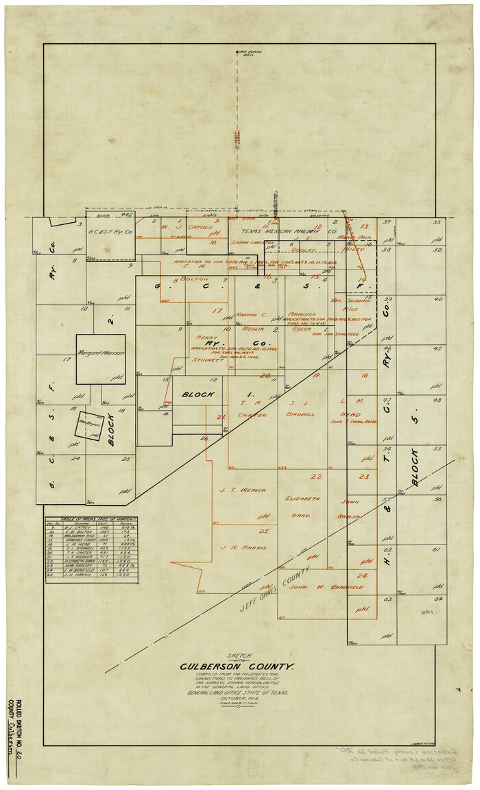
Culberson County Rolled Sketch 20
Print $20.00
- Digital $50.00
Culberson County Rolled Sketch 20
1912
Size 30.0 x 18.2 inches
Map/Doc 5653
University Land in Grayson County in Two Parts

Print $20.00
- Digital $50.00
University Land in Grayson County in Two Parts
Size 30.6 x 25.8 inches
Map/Doc 62965