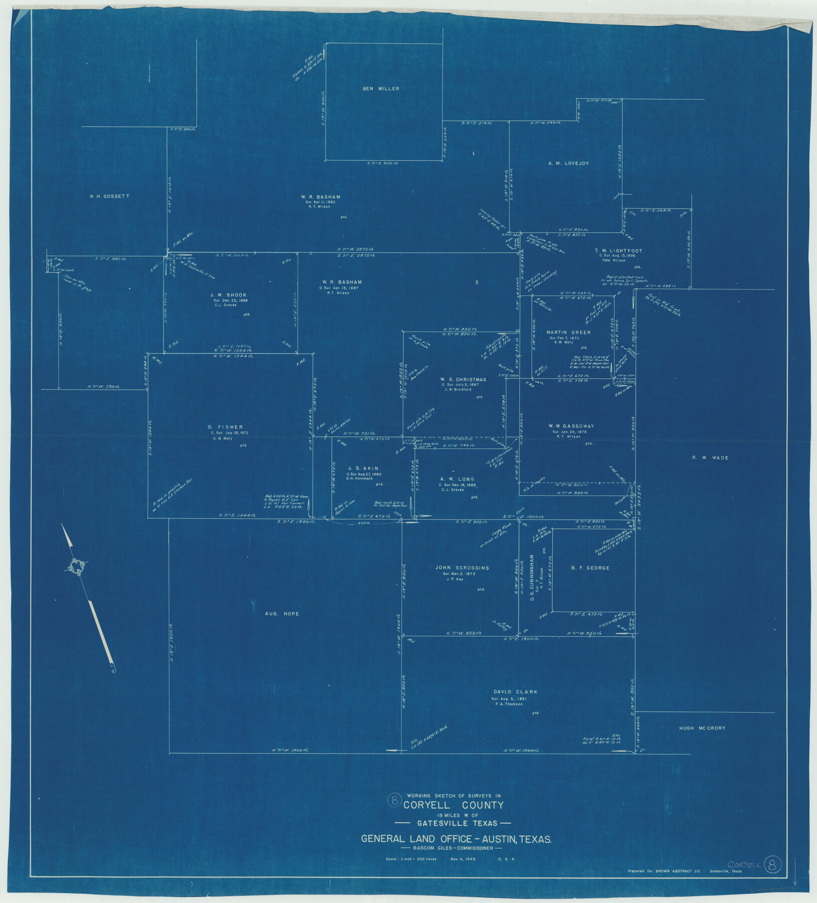
Coryell County Working Sketch 8
-
Map/Doc
68215
-
Collection
General Map Collection
-
Object Dates
11/4/1945 (Creation Date)
-
People and Organizations
Otto G. Kurio (Draftsman)
-
Counties
Coryell
-
Subjects
Surveying Working Sketch
-
Height x Width
36.5 x 33.0 inches
92.7 x 83.8 cm
-
Scale
1" = 200 varas
Part of: General Map Collection
Amistad International Reservoir on Rio Grande 92

Print $20.00
- Digital $50.00
Amistad International Reservoir on Rio Grande 92
1950
Size 28.5 x 40.6 inches
Map/Doc 75522
Zavala County Sketch File 18

Print $16.00
- Digital $50.00
Zavala County Sketch File 18
1897
Size 14.0 x 9.1 inches
Map/Doc 41356
Chambers County Sketch File 40

Print $35.00
- Digital $50.00
Chambers County Sketch File 40
1925
Size 14.0 x 8.5 inches
Map/Doc 17677
Real County Working Sketch 63

Print $20.00
- Digital $50.00
Real County Working Sketch 63
1967
Size 28.8 x 32.3 inches
Map/Doc 71955
Karnes County Working Sketch 2

Print $20.00
- Digital $50.00
Karnes County Working Sketch 2
1939
Size 18.8 x 20.0 inches
Map/Doc 66650
Gregg County Rolled Sketch 9A

Print $20.00
- Digital $50.00
Gregg County Rolled Sketch 9A
1932
Size 38.1 x 30.2 inches
Map/Doc 6035
Flight Mission No. CGI-3N, Frame 166, Cameron County

Print $20.00
- Digital $50.00
Flight Mission No. CGI-3N, Frame 166, Cameron County
1954
Size 18.6 x 22.2 inches
Map/Doc 84630
Loving County Working Sketch 16a

Print $20.00
- Digital $50.00
Loving County Working Sketch 16a
1976
Size 45.4 x 29.3 inches
Map/Doc 70650
Lamar County Working Sketch 12

Print $20.00
- Digital $50.00
Lamar County Working Sketch 12
1994
Size 40.3 x 34.4 inches
Map/Doc 70273
Red River County Working Sketch 74

Print $20.00
- Digital $50.00
Red River County Working Sketch 74
1980
Size 24.2 x 22.8 inches
Map/Doc 72057
Map of the State University & Public School Lands in Reeves and El Paso Cos.

Print $40.00
- Digital $50.00
Map of the State University & Public School Lands in Reeves and El Paso Cos.
1884
Size 39.1 x 56.3 inches
Map/Doc 2434
Stonewall County Sketch File 16

Print $16.00
- Digital $50.00
Stonewall County Sketch File 16
1902
Size 12.8 x 8.3 inches
Map/Doc 37266
You may also like
[Plan for Fort Waul near Gonzales, Texas]
![88600, [Plan for Fort Waul near Gonzales, Texas], National Archives Digital Map Collection](https://historictexasmaps.com/wmedia_w700/maps/88600.tif.jpg)
Print $20.00
[Plan for Fort Waul near Gonzales, Texas]
1863
Size 12.3 x 20.3 inches
Map/Doc 88600
Burnet County Sketch File 22

Print $4.00
- Digital $50.00
Burnet County Sketch File 22
1871
Size 9.6 x 7.9 inches
Map/Doc 16716
Flight Mission No. DQN-7K, Frame 35, Calhoun County

Print $20.00
- Digital $50.00
Flight Mission No. DQN-7K, Frame 35, Calhoun County
1953
Size 18.5 x 22.1 inches
Map/Doc 84473
Flight Mission No. BRA-8M, Frame 145, Jefferson County

Print $20.00
- Digital $50.00
Flight Mission No. BRA-8M, Frame 145, Jefferson County
1953
Size 16.0 x 15.9 inches
Map/Doc 85637
Crane County Rolled Sketch 20

Print $20.00
- Digital $50.00
Crane County Rolled Sketch 20
Size 44.5 x 34.6 inches
Map/Doc 8684
Northern Part of Laguna Madre

Print $20.00
- Digital $50.00
Northern Part of Laguna Madre
1988
Size 45.1 x 36.4 inches
Map/Doc 73531
Dimmit County Sketch File 23

Print $38.00
- Digital $50.00
Dimmit County Sketch File 23
1894
Size 10.0 x 11.8 inches
Map/Doc 21133
Showing Position of Original and Re-Survey Corners in Lynn, Terry, Yoakum, Gaines and Dawson Counties, Texas

Print $40.00
- Digital $50.00
Showing Position of Original and Re-Survey Corners in Lynn, Terry, Yoakum, Gaines and Dawson Counties, Texas
1946
Size 57.3 x 22.1 inches
Map/Doc 93044
[Surveys along the San Antonio Road near Caldwell]
![69760, [Surveys along the San Antonio Road near Caldwell], General Map Collection](https://historictexasmaps.com/wmedia_w700/maps/69760.tif.jpg)
Print $2.00
- Digital $50.00
[Surveys along the San Antonio Road near Caldwell]
1846
Size 9.2 x 7.7 inches
Map/Doc 69760
Map of Texas and the Countries Adjacent compiled in the Bureau of the Corps of Topographical Engineers from the Best Authorities

Print $20.00
- Digital $50.00
Map of Texas and the Countries Adjacent compiled in the Bureau of the Corps of Topographical Engineers from the Best Authorities
1844
Size 22.3 x 33.4 inches
Map/Doc 93867
Hardin County Sketch File 65

Print $15.00
- Digital $50.00
Hardin County Sketch File 65
Size 14.4 x 9.0 inches
Map/Doc 25245
Harris County Sketch File 95

Print $20.00
- Digital $50.00
Harris County Sketch File 95
1952
Size 31.6 x 17.1 inches
Map/Doc 11678