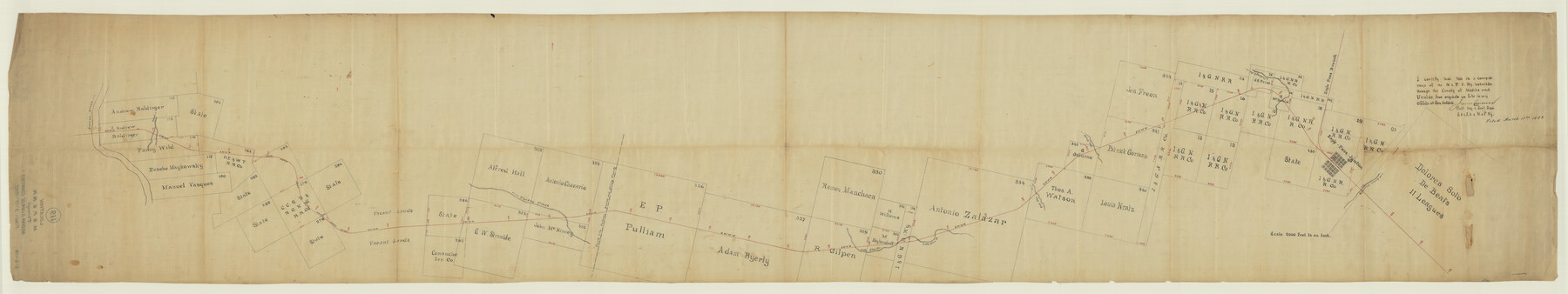
Location Map of Memphis, El Paso & Pacific Railroad through Medina & Uvalde Counties
Z-2-119
-
Map/Doc
64444
-
Collection
General Map Collection
-
Object Dates
1882 (Creation Date)
1882/3/17 (File Date)
-
Counties
Uvalde Medina Kinney
-
Subjects
Railroads
-
Height x Width
19.2 x 102.0 inches
48.8 x 259.1 cm
-
Medium
paper, manuscript
-
Comments
Eagle Pass Branch
-
Features
MEP&P
Nueces River
Turkey Creek
Little Elm Creek
East Elm Creek
Elm Creek
Lindsay's Creek
Eagle Pass Branch
Eagle Pass Junction
Arroyo Imperialis
Part of: General Map Collection
Reeves County Rolled Sketch 33

Print $20.00
- Digital $50.00
Reeves County Rolled Sketch 33
Size 24.2 x 36.5 inches
Map/Doc 7502
Kerr County Boundary File 5

Print $8.00
- Digital $50.00
Kerr County Boundary File 5
Size 14.2 x 8.7 inches
Map/Doc 64818

Anderson County Working Sketch 34

Print $20.00
- Digital $50.00
Anderson County Working Sketch 34
1967
Size 32.1 x 47.7 inches
Map/Doc 67034
[Oceani occidentalis seu terrae novae tabula]
![95835, [Oceani occidentalis seu Terre Noue Tabula Christophorus Columbus], General Map Collection](https://historictexasmaps.com/wmedia_w700/maps/95835-1.tif.jpg)
Print $20.00
- Digital $50.00
[Oceani occidentalis seu terrae novae tabula]
1535
Size 16.0 x 21.6 inches
Map/Doc 95835
Flight Mission No. BRA-6M, Frame 88, Jefferson County

Print $20.00
- Digital $50.00
Flight Mission No. BRA-6M, Frame 88, Jefferson County
1953
Size 18.4 x 22.4 inches
Map/Doc 85431

Brewster County Rolled Sketch 63

Print $40.00
- Digital $50.00
Brewster County Rolled Sketch 63
1939
Size 77.1 x 43.6 inches
Map/Doc 8488
Caldwell County Working Sketch 11

Print $20.00
- Digital $50.00
Caldwell County Working Sketch 11
1979
Size 21.6 x 26.6 inches
Map/Doc 67841
Coleman County Working Sketch Graphic Index

Print $40.00
- Digital $50.00
Coleman County Working Sketch Graphic Index
1945
Size 54.0 x 36.3 inches
Map/Doc 76497
Rusk County Working Sketch Graphic Index

Print $20.00
- Digital $50.00
Rusk County Working Sketch Graphic Index
1932
Size 45.6 x 34.9 inches
Map/Doc 76688
Brewster County Working Sketch 47

Print $20.00
- Digital $50.00
Brewster County Working Sketch 47
1949
Size 42.9 x 35.4 inches
Map/Doc 67581
You may also like
Red River County Sketch File 2

Print $8.00
- Digital $50.00
Red River County Sketch File 2
1852
Size 12.9 x 8.5 inches
Map/Doc 35095
Val Verde County Working Sketch 86

Print $20.00
- Digital $50.00
Val Verde County Working Sketch 86
1973
Size 42.1 x 43.8 inches
Map/Doc 72221
[Sketch of Blocks D5-D8]
![93046, [Sketch of Blocks D5-D8], Twichell Survey Records](https://historictexasmaps.com/wmedia_w700/maps/93046-1.tif.jpg)
Print $20.00
- Digital $50.00
[Sketch of Blocks D5-D8]
Size 43.1 x 28.3 inches
Map/Doc 93046
Crockett County Sketch File 77

Print $8.00
- Digital $50.00
Crockett County Sketch File 77
1932
Size 11.2 x 8.7 inches
Map/Doc 19877
Chambers County Working Sketch 9

Print $20.00
- Digital $50.00
Chambers County Working Sketch 9
1946
Size 43.9 x 29.8 inches
Map/Doc 67992
Map of the Fort Worth & Denver City Railway

Print $40.00
- Digital $50.00
Map of the Fort Worth & Denver City Railway
1887
Size 22.2 x 79.5 inches
Map/Doc 64459
Concho County Sketch File 2

Print $4.00
- Digital $50.00
Concho County Sketch File 2
1859
Size 10.5 x 8.5 inches
Map/Doc 19122
J. De Cordova's Map of the State of Texas Compiled from the records of the General Land Office of the State

Print $20.00
- Digital $50.00
J. De Cordova's Map of the State of Texas Compiled from the records of the General Land Office of the State
1849
Size 33.7 x 36.1 inches
Map/Doc 94026
Pecos County Rolled Sketch CM-2

Print $20.00
- Digital $50.00
Pecos County Rolled Sketch CM-2
1938
Size 33.6 x 41.3 inches
Map/Doc 9716
Brazos River, Brazos River Sheet 6

Print $4.00
- Digital $50.00
Brazos River, Brazos River Sheet 6
1926
Size 29.0 x 24.3 inches
Map/Doc 65299
Aransas County Rolled Sketch 27D

Print $20.00
- Digital $50.00
Aransas County Rolled Sketch 27D
1930
Size 40.5 x 40.2 inches
Map/Doc 8418
Flight Mission No. BRA-3M, Frame 192, Jefferson County

Print $20.00
- Digital $50.00
Flight Mission No. BRA-3M, Frame 192, Jefferson County
1953
Size 18.5 x 22.4 inches
Map/Doc 85407