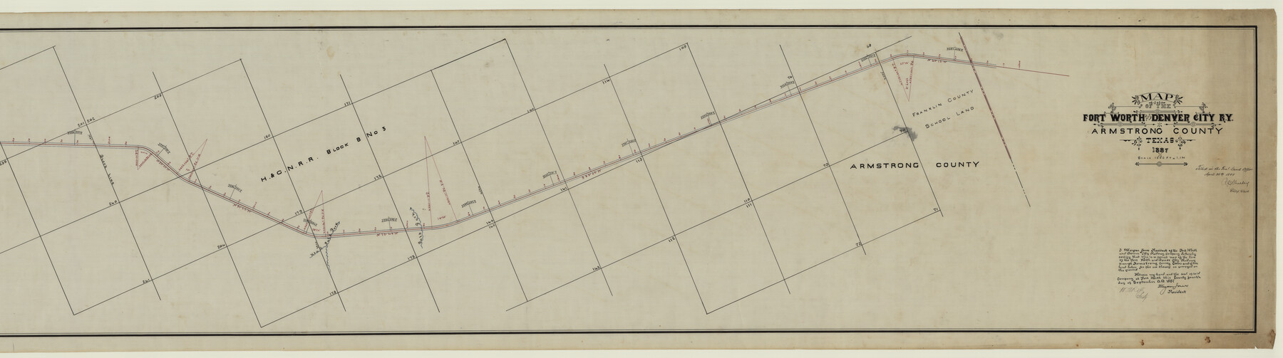
Map of the Fort Worth & Denver City Railway
Z-2-126
-
Map/Doc
64459
-
Collection
General Map Collection
-
Object Dates
1888/4/26 (File Date)
1887 (Creation Date)
-
Counties
Armstrong
-
Subjects
Railroads
-
Height x Width
22.2 x 79.5 inches
56.4 x 201.9 cm
-
Medium
linen, manuscript
-
Scale
1000 ft. = 1 in.
-
Comments
Segment 2; see counter no. 64458 for segment 1.
-
Features
FW&DC
Head Salt Fork
Salt Fork
Part of: General Map Collection
San Augustine Co.

Print $20.00
- Digital $50.00
San Augustine Co.
1949
Size 45.7 x 28.6 inches
Map/Doc 77414
Harrison County Sketch File 6

Print $4.00
- Digital $50.00
Harrison County Sketch File 6
Size 12.9 x 8.1 inches
Map/Doc 26044
Aransas County Sketch File 22

Print $34.00
- Digital $50.00
Aransas County Sketch File 22
1910
Size 14.8 x 9.1 inches
Map/Doc 13166
Angelina County Working Sketch 40

Print $20.00
- Digital $50.00
Angelina County Working Sketch 40
1960
Size 14.2 x 18.8 inches
Map/Doc 67123
Lamb County Working Sketch 3

Print $20.00
- Digital $50.00
Lamb County Working Sketch 3
1962
Size 32.1 x 37.7 inches
Map/Doc 70276
Frio County Working Sketch 23

Print $20.00
- Digital $50.00
Frio County Working Sketch 23
1992
Size 27.6 x 35.4 inches
Map/Doc 69297
Webb County Sketch File 9-1

Print $20.00
- Digital $50.00
Webb County Sketch File 9-1
1879
Size 15.8 x 15.7 inches
Map/Doc 12622
[Surveys in Power and Hewetson's Colony along the Aransas River, shown as Aransasu and Chiltipin Creek]
![31, [Surveys in Power and Hewetson's Colony along the Aransas River, shown as Aransasu and Chiltipin Creek], General Map Collection](https://historictexasmaps.com/wmedia_w700/maps/31.tif.jpg)
Print $20.00
- Digital $50.00
[Surveys in Power and Hewetson's Colony along the Aransas River, shown as Aransasu and Chiltipin Creek]
Size 12.9 x 17.0 inches
Map/Doc 31
United States Atlantic and Gulf Coasts Including Puerto Rico and the Virgin Islands

Print $40.00
- Digital $50.00
United States Atlantic and Gulf Coasts Including Puerto Rico and the Virgin Islands
1973
Size 21.5 x 60.4 inches
Map/Doc 76126
Hamilton County Working Sketch 26

Print $20.00
- Digital $50.00
Hamilton County Working Sketch 26
1964
Size 22.8 x 29.6 inches
Map/Doc 63364
Flight Mission No. CON-4R, Frame 200, Stonewall County

Print $20.00
- Digital $50.00
Flight Mission No. CON-4R, Frame 200, Stonewall County
1957
Size 18.2 x 22.0 inches
Map/Doc 86994
Flight Mission No. DCL-6C, Frame 2, Kenedy County

Print $20.00
- Digital $50.00
Flight Mission No. DCL-6C, Frame 2, Kenedy County
1943
Size 18.6 x 22.4 inches
Map/Doc 85862
You may also like

Travis County Rolled Sketch 47

Print $40.00
- Digital $50.00
Travis County Rolled Sketch 47
1928
Size 57.3 x 26.1 inches
Map/Doc 10627
Trinity River, Clapps Ferry Sheet

Print $20.00
- Digital $50.00
Trinity River, Clapps Ferry Sheet
1925
Size 47.5 x 36.4 inches
Map/Doc 65180
Real County Working Sketch 57

Print $20.00
- Digital $50.00
Real County Working Sketch 57
1962
Size 19.6 x 25.8 inches
Map/Doc 71949
Flight Mission No. DQO-2K, Frame 141, Galveston County

Print $20.00
- Digital $50.00
Flight Mission No. DQO-2K, Frame 141, Galveston County
1952
Size 18.9 x 22.5 inches
Map/Doc 85038
Sterling County Working Sketch 9

Print $20.00
- Digital $50.00
Sterling County Working Sketch 9
1980
Size 30.3 x 41.1 inches
Map/Doc 63991
Hunt County Sketch File 4

Print $4.00
- Digital $50.00
Hunt County Sketch File 4
1852
Size 12.1 x 7.7 inches
Map/Doc 27087
Bexar County Sketch File 49

Print $8.00
- Digital $50.00
Bexar County Sketch File 49
1874
Size 12.6 x 8.3 inches
Map/Doc 14530
Bailey County

Print $20.00
- Digital $50.00
Bailey County
1913
Size 28.8 x 22.3 inches
Map/Doc 66707
Somervell County

Print $20.00
- Digital $50.00
Somervell County
1941
Size 29.2 x 27.1 inches
Map/Doc 95642
[C. C. S. D. & R. G. N. G Ry. Co. Block in NW of County]
![90821, [C. C. S. D. & R. G. N. G Ry. Co. Block in NW of County], Twichell Survey Records](https://historictexasmaps.com/wmedia_w700/maps/90821-2.tif.jpg)
Print $20.00
- Digital $50.00
[C. C. S. D. & R. G. N. G Ry. Co. Block in NW of County]
Size 17.3 x 22.0 inches
Map/Doc 90821
Working Sketch Cochran and Yoakum Co's.

Print $40.00
- Digital $50.00
Working Sketch Cochran and Yoakum Co's.
1919
Size 54.5 x 16.4 inches
Map/Doc 89676