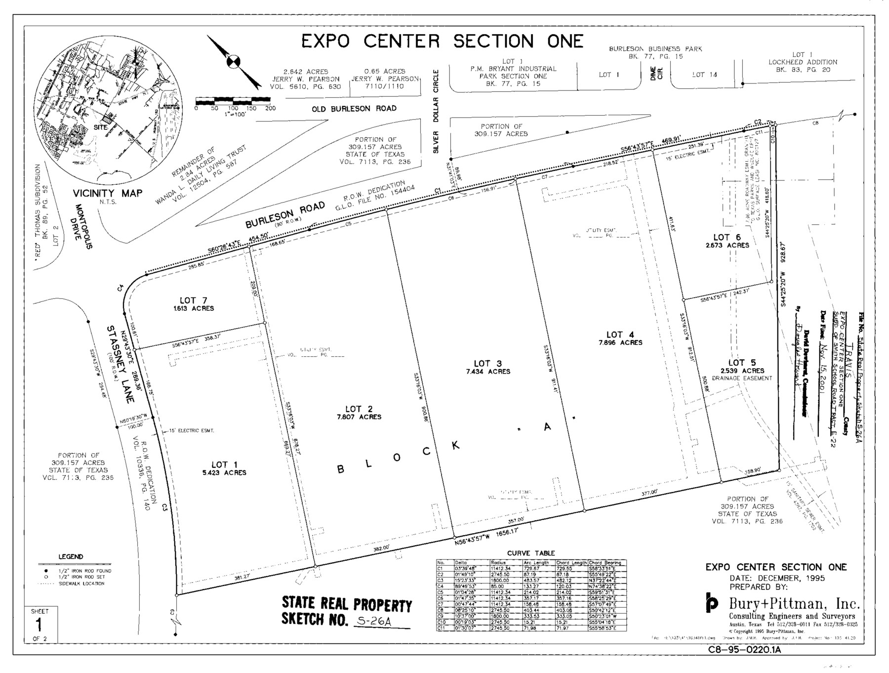
Travis County State Real Property Sketch 14
Report and Sketch of Expo Center Section One, Subdivision of Smith School Road Tract Escheat - 22, Lots 1 through 7
State Real Property Sketch S - 26
-
Map/Doc
61672
-
Collection
General Map Collection
-
Object Dates
1995 (Creation Date)
2001/11/15 (File Date)
-
People and Organizations
Bury + Pittman, Inc. (Publisher)
Bury + Pittman, Inc. (Printer)
John T. Bilnoski (Surveyor/Engineer)
J.M.B. (Draftsman)
J.M.B. (Compiler)
-
Counties
Travis
-
Subjects
State Real Property
-
Height x Width
18.1 x 23.9 inches
46.0 x 60.7 cm
-
Comments
Surveys located about eight miles South 10 degrees East of Austin, Texas.
Part of: General Map Collection
Lamar County Sketch File 11

Print $24.00
- Digital $50.00
Lamar County Sketch File 11
1934
Size 11.5 x 7.2 inches
Map/Doc 29295
Val Verde County Sketch File XXX2

Print $20.00
- Digital $50.00
Val Verde County Sketch File XXX2
Size 18.6 x 17.9 inches
Map/Doc 12548
Wood County Sketch File 13

Print $24.00
- Digital $50.00
Wood County Sketch File 13
1866
Size 12.5 x 7.6 inches
Map/Doc 40668
[F. W. & D. C. Ry. Co. Alignment and Right of Way Map, Clay County]
![64726, [F. W. & D. C. Ry. Co. Alignment and Right of Way Map, Clay County], General Map Collection](https://historictexasmaps.com/wmedia_w700/maps/64726-1.tif.jpg)
Print $20.00
- Digital $50.00
[F. W. & D. C. Ry. Co. Alignment and Right of Way Map, Clay County]
1927
Size 18.6 x 11.8 inches
Map/Doc 64726
Van Zandt County Sketch File 19a

Print $4.00
- Digital $50.00
Van Zandt County Sketch File 19a
1858
Size 7.1 x 8.0 inches
Map/Doc 39424
Hudspeth County Rolled Sketch 58

Print $20.00
- Digital $50.00
Hudspeth County Rolled Sketch 58
Size 31.4 x 32.6 inches
Map/Doc 6258
Harris County Sketch File AA-1

Print $20.00
- Digital $50.00
Harris County Sketch File AA-1
Size 19.0 x 26.1 inches
Map/Doc 11646
Sutton County Working Sketch 25

Print $40.00
- Digital $50.00
Sutton County Working Sketch 25
Size 69.4 x 37.1 inches
Map/Doc 62368

Crockett County Sketch File 84

Print $6.00
- Digital $50.00
Crockett County Sketch File 84
1942
Size 11.4 x 8.9 inches
Map/Doc 19905
Wood County Working Sketch 2

Print $20.00
- Digital $50.00
Wood County Working Sketch 2
1913
Size 17.8 x 16.8 inches
Map/Doc 62002
Live Oak County

Print $40.00
- Digital $50.00
Live Oak County
1899
Size 50.3 x 35.3 inches
Map/Doc 16882
You may also like
Flight Mission No. DAG-24K, Frame 151, Matagorda County

Print $20.00
- Digital $50.00
Flight Mission No. DAG-24K, Frame 151, Matagorda County
1953
Size 18.5 x 22.1 inches
Map/Doc 86565
Jim Nix Farm NW 1/4 Section 40, Block 1 Halsell Subdivision

Print $20.00
- Digital $50.00
Jim Nix Farm NW 1/4 Section 40, Block 1 Halsell Subdivision
Size 12.1 x 13.9 inches
Map/Doc 92400
Sherman Co., U. S. Public Land

Print $20.00
- Digital $50.00
Sherman Co., U. S. Public Land
Size 15.5 x 17.4 inches
Map/Doc 91895
Pecos County Sketch File 119

Print $6.00
- Digital $50.00
Pecos County Sketch File 119
1925
Size 11.2 x 8.8 inches
Map/Doc 34111

Texas State Boundary Line 9

Print $174.00
Texas State Boundary Line 9
2000
Size 11.3 x 8.8 inches
Map/Doc 75076
Flight Mission No. BRA-8M, Frame 23, Jefferson County

Print $20.00
- Digital $50.00
Flight Mission No. BRA-8M, Frame 23, Jefferson County
1953
Size 18.7 x 22.3 inches
Map/Doc 85578
The Mexican Municipality of Harrisburg. Defined, January 4, 1836

Print $20.00
The Mexican Municipality of Harrisburg. Defined, January 4, 1836
2020
Size 18.4 x 21.7 inches
Map/Doc 96022
Flight Mission No. DQN-2K, Frame 145, Calhoun County

Print $20.00
- Digital $50.00
Flight Mission No. DQN-2K, Frame 145, Calhoun County
1953
Size 18.9 x 22.7 inches
Map/Doc 84314
Zavala County Sketch File 37

Print $4.00
- Digital $50.00
Zavala County Sketch File 37
Size 12.9 x 8.1 inches
Map/Doc 41402
Travis County Working Sketch 52

Print $20.00
- Digital $50.00
Travis County Working Sketch 52
1985
Size 28.2 x 10.0 inches
Map/Doc 69436
Culberson County Working Sketch 60

Print $40.00
- Digital $50.00
Culberson County Working Sketch 60
1974
Size 74.7 x 32.7 inches
Map/Doc 68514