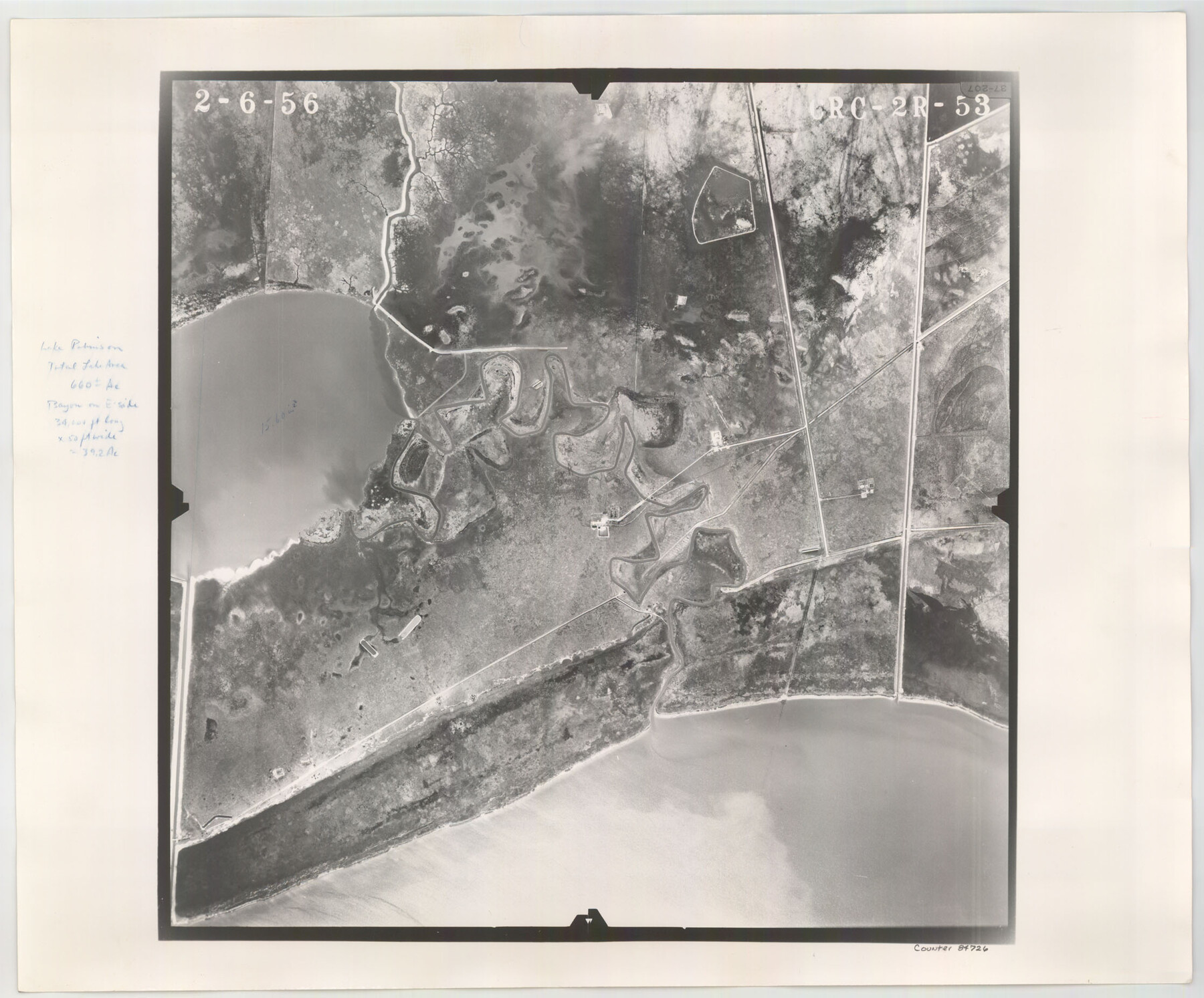
Flight Mission No. CRC-2R, Frame 53, Chambers County
CRC-2R-53
-
Map/Doc
84726
-
Collection
General Map Collection
-
Object Dates
1956/2/6 (Creation Date)
-
People and Organizations
U. S. Department of Agriculture (Publisher)
-
Counties
Chambers
-
Subjects
Aerial Photograph
-
Height x Width
18.5 x 22.4 inches
47.0 x 56.9 cm
-
Comments
Flown by Jack Ammann Photogrammetric Engineers, Inc. of San Antonio, Texas.
Part of: General Map Collection
Milam County Working Sketch 5

Print $20.00
- Digital $50.00
Milam County Working Sketch 5
1963
Size 29.1 x 23.7 inches
Map/Doc 71020
Cottle County Rolled Sketch 11

Print $20.00
- Digital $50.00
Cottle County Rolled Sketch 11
1927
Size 31.6 x 24.1 inches
Map/Doc 5568
Pecos County Sketch File 54

Print $20.00
- Digital $50.00
Pecos County Sketch File 54
Size 14.5 x 22.4 inches
Map/Doc 12180
Kimble County Working Sketch 37

Print $20.00
- Digital $50.00
Kimble County Working Sketch 37
1946
Size 34.3 x 20.6 inches
Map/Doc 70105
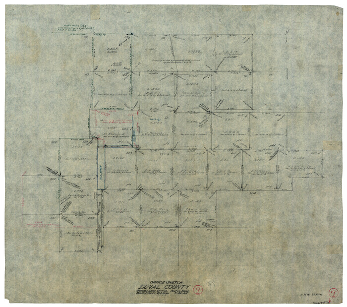
Duval County Working Sketch 9
Print $20.00
- Digital $50.00
Duval County Working Sketch 9
1935
Size 25.8 x 29.1 inches
Map/Doc 68722

Current Miscellaneous File 92

Print $22.00
- Digital $50.00
Current Miscellaneous File 92
1990
Size 11.2 x 8.8 inches
Map/Doc 74265
Flight Mission No. BRE-2P, Frame 47, Nueces County

Print $20.00
- Digital $50.00
Flight Mission No. BRE-2P, Frame 47, Nueces County
1956
Size 18.6 x 22.6 inches
Map/Doc 86749
Blanco County Sketch File 21

Print $6.00
- Digital $50.00
Blanco County Sketch File 21
1881
Size 15.6 x 11.2 inches
Map/Doc 14600
Pecos County Rolled Sketch 152

Print $20.00
- Digital $50.00
Pecos County Rolled Sketch 152
1960
Size 38.8 x 43.7 inches
Map/Doc 9736
Baffin Bay, Texas from Penescal Triangulation Station to Bovido Triangulation Station

Print $40.00
- Digital $50.00
Baffin Bay, Texas from Penescal Triangulation Station to Bovido Triangulation Station
1881
Size 32.6 x 54.2 inches
Map/Doc 73484
Brewster County Sketch File N-3c

Print $4.00
- Digital $50.00
Brewster County Sketch File N-3c
Size 12.7 x 8.4 inches
Map/Doc 15594
You may also like
Current Miscellaneous File 23

Print $4.00
- Digital $50.00
Current Miscellaneous File 23
1953
Size 14.1 x 5.5 inches
Map/Doc 73881
Schleicher County Rolled Sketch 10

Print $20.00
- Digital $50.00
Schleicher County Rolled Sketch 10
Size 28.9 x 29.1 inches
Map/Doc 7752
[Capitol lands granted for purpose of building State Capitol]
![2073, [Capitol lands granted for purpose of building State Capitol], General Map Collection](https://historictexasmaps.com/wmedia_w700/maps/2073.tif.jpg)
Print $20.00
- Digital $50.00
[Capitol lands granted for purpose of building State Capitol]
1956
Size 31.5 x 13.0 inches
Map/Doc 2073
Presidio County Rolled Sketch 131A

Print $40.00
- Digital $50.00
Presidio County Rolled Sketch 131A
1991
Size 37.6 x 49.7 inches
Map/Doc 10713
[Block D, John H. Gibson]
![92003, [Block D, John H. Gibson], Twichell Survey Records](https://historictexasmaps.com/wmedia_w700/maps/92003-1.tif.jpg)
Print $20.00
- Digital $50.00
[Block D, John H. Gibson]
Size 33.2 x 18.4 inches
Map/Doc 92003
Dimmit County Sketch File 8

Print $20.00
- Digital $50.00
Dimmit County Sketch File 8
1875
Size 18.2 x 29.1 inches
Map/Doc 11337
Childress County Sketch File 13

Print $12.00
- Digital $50.00
Childress County Sketch File 13
1896
Size 6.4 x 8.7 inches
Map/Doc 18266
Flight Mission No. CUG-3P, Frame 14, Kleberg County

Print $20.00
- Digital $50.00
Flight Mission No. CUG-3P, Frame 14, Kleberg County
1956
Size 18.7 x 22.3 inches
Map/Doc 86224
The railroad system of Texas on September 1st, 1883

Print $20.00
The railroad system of Texas on September 1st, 1883
1883
Size 20.1 x 26.8 inches
Map/Doc 93618
Ellwood Place, Installment No. 3

Print $20.00
- Digital $50.00
Ellwood Place, Installment No. 3
Size 17.8 x 24.9 inches
Map/Doc 92791
Flight Mission No. CUG-1P, Frame 50, Kleberg County

Print $20.00
- Digital $50.00
Flight Mission No. CUG-1P, Frame 50, Kleberg County
1956
Size 18.6 x 22.3 inches
Map/Doc 86128
Selected List of Wells accompanying Map of Wyoming showing Test Wells for Oil and Gas, Anticlinal Axes, Oil and Gas Fields, Pipelines, Unit Areas, and Land 3 District Boundaries, 1949

Print $20.00
- Digital $50.00
Selected List of Wells accompanying Map of Wyoming showing Test Wells for Oil and Gas, Anticlinal Axes, Oil and Gas Fields, Pipelines, Unit Areas, and Land 3 District Boundaries, 1949
1949
Size 26.2 x 41.5 inches
Map/Doc 89690