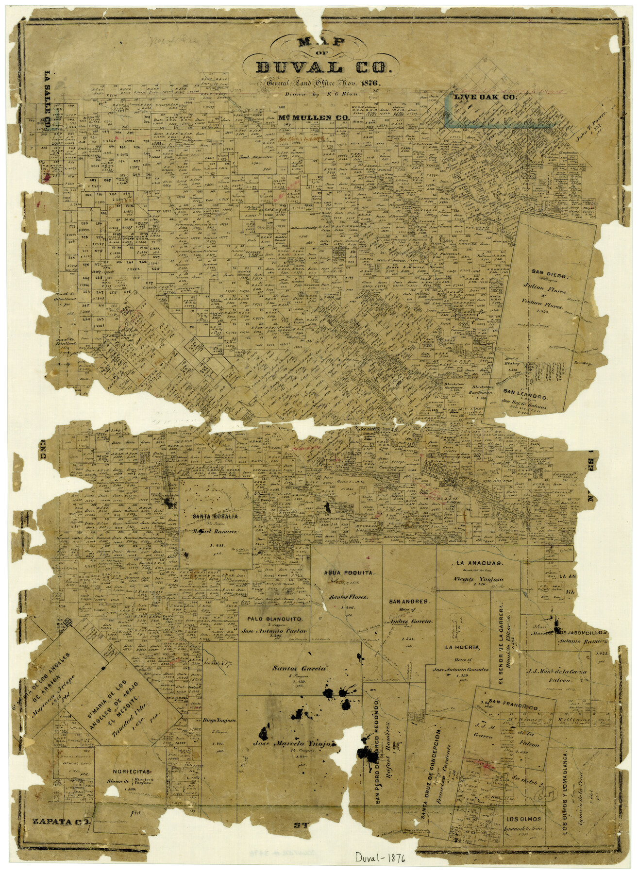
Map of Duval County
-
Map/Doc
3498
-
Collection
General Map Collection
-
Object Dates
11/1876 (Creation Date)
-
People and Organizations
F.G. Blau (Draftsman)
-
Counties
Duval
-
Subjects
County
-
Height x Width
29.6 x 21.5 inches
75.2 x 54.6 cm
-
Features
Piedra Creek
Olmito Road
San Diego Creek
Piedras Pintos Creek
Trinidad River
Animas Creek
Road to Rio Grande
Palo Blanco Creek
Cibolo Creek
Aroyo [sic] de Los Angeles
Aroyo [sic] de Noriesitas
Olmos Creek
Resaca de Eumodio
Derramadera de las Anaquilas
Piedras Platas Creek
Tubares Creek
Santa Rosalia Creek
Palo Banquito
Los Indios Rancho
San Pedro de Charco Redondo
La Baconena Creek
Charco Redondo
Corpus Christi to Laredo Road
Arroyo Solidad
Piscachar Creek
Chiltipin Creek
Collins Creek
Loma Chato Creek
Muerto Creek
Road to Eagle Pass
San Diego
Tarancahuas Creek
San Juan Creek
Roda Meadero Becera Creek
Corpus Christi Road
Laredo Road
Parrilla Creek
Palo Blanquito Creek
Aqua Paquita Creek
San Diego to Mier Road
San Diego Road
Mier Road
Tia Baronena Creek
Concepcion Creek
Part of: General Map Collection
Culberson County Rolled Sketch 43

Print $20.00
- Digital $50.00
Culberson County Rolled Sketch 43
1947
Size 20.5 x 36.7 inches
Map/Doc 5664
Hardin County Working Sketch 32

Print $20.00
- Digital $50.00
Hardin County Working Sketch 32
1978
Size 41.7 x 38.0 inches
Map/Doc 63430
Wilbarger County Sketch File 7a

Print $4.00
- Digital $50.00
Wilbarger County Sketch File 7a
1885
Size 14.3 x 8.6 inches
Map/Doc 40177
Refugio County Boundary File 2

Print $32.00
- Digital $50.00
Refugio County Boundary File 2
Size 14.1 x 8.8 inches
Map/Doc 58233
Shelby County Working Sketch 31a

Print $40.00
- Digital $50.00
Shelby County Working Sketch 31a
2003
Size 32.6 x 70.2 inches
Map/Doc 78643
Wharton County Sketch File 6

Print $4.00
- Digital $50.00
Wharton County Sketch File 6
1877
Size 8.6 x 14.2 inches
Map/Doc 39923
Presidio County Rolled Sketch 83A

Print $20.00
- Digital $50.00
Presidio County Rolled Sketch 83A
1930
Size 28.2 x 27.6 inches
Map/Doc 7370
Gulf Oil Corp. Fishgide - Port Isabel

Gulf Oil Corp. Fishgide - Port Isabel
1960
Size 22.0 x 11.9 inches
Map/Doc 75980
Newton County Sketch File 48

Print $4.00
- Digital $50.00
Newton County Sketch File 48
Size 12.4 x 7.9 inches
Map/Doc 32460
Montague County Rolled Sketch 9

Print $20.00
- Digital $50.00
Montague County Rolled Sketch 9
Size 29.1 x 39.4 inches
Map/Doc 6793
Maverick County Sketch File 14

Print $4.00
- Digital $50.00
Maverick County Sketch File 14
1883
Size 11.1 x 8.5 inches
Map/Doc 31111
Dickens County Sketch File H4

Print $4.00
- Digital $50.00
Dickens County Sketch File H4
Size 9.1 x 14.8 inches
Map/Doc 20881
You may also like
Denton County Sketch File 22

Print $4.00
- Digital $50.00
Denton County Sketch File 22
1872
Size 8.5 x 16.0 inches
Map/Doc 20746
Current Miscellaneous File 35

Print $10.00
- Digital $50.00
Current Miscellaneous File 35
Size 14.2 x 8.7 inches
Map/Doc 73947
[Sketch for Mineral Application 16700 - Pecos River Bed]
![2806, [Sketch for Mineral Application 16700 - Pecos River Bed], General Map Collection](https://historictexasmaps.com/wmedia_w700/maps/2806.tif.jpg)
Print $20.00
- Digital $50.00
[Sketch for Mineral Application 16700 - Pecos River Bed]
1927
Size 20.3 x 29.1 inches
Map/Doc 2806
Flight Mission No. DQO-8K, Frame 44, Galveston County

Print $20.00
- Digital $50.00
Flight Mission No. DQO-8K, Frame 44, Galveston County
1952
Size 18.5 x 22.3 inches
Map/Doc 85151
Flight Mission No. DCL-6C, Frame 125, Kenedy County

Print $20.00
- Digital $50.00
Flight Mission No. DCL-6C, Frame 125, Kenedy County
1943
Size 18.7 x 22.3 inches
Map/Doc 85955
Flight Mission No. BRA-8M, Frame 24, Jefferson County

Print $20.00
- Digital $50.00
Flight Mission No. BRA-8M, Frame 24, Jefferson County
1953
Size 18.7 x 22.3 inches
Map/Doc 85579
Dawson County Working Sketch 18

Print $40.00
- Digital $50.00
Dawson County Working Sketch 18
1963
Size 41.2 x 58.3 inches
Map/Doc 68562
Le Golfe de Mexique, et les Provinces et Isles qui l'Environe comme sont la Floride au nord, le Mexique ou Nouvelle Espagne a l'ouest, la Terre-Ferme au sud, les Is. Antilles, Lucayes, St. Domingue et Jamaique a l'est

Print $20.00
- Digital $50.00
Le Golfe de Mexique, et les Provinces et Isles qui l'Environe comme sont la Floride au nord, le Mexique ou Nouvelle Espagne a l'ouest, la Terre-Ferme au sud, les Is. Antilles, Lucayes, St. Domingue et Jamaique a l'est
1717
Size 20.2 x 25.7 inches
Map/Doc 95923
State Prison Lands Transferred to A&M College, Forest Division, Cherokee County

Print $4.00
- Digital $50.00
State Prison Lands Transferred to A&M College, Forest Division, Cherokee County
1932
Size 11.1 x 20.1 inches
Map/Doc 65086
![92508, [Block A31], Twichell Survey Records](https://historictexasmaps.com/wmedia_w700/maps/92508-1.tif.jpg)
Roberts County Working Sketch 19

Print $20.00
- Digital $50.00
Roberts County Working Sketch 19
1975
Size 30.7 x 39.9 inches
Map/Doc 63545
Flight Mission No. DAG-24K, Frame 139, Matagorda County

Print $20.00
- Digital $50.00
Flight Mission No. DAG-24K, Frame 139, Matagorda County
1953
Size 18.5 x 22.3 inches
Map/Doc 86557