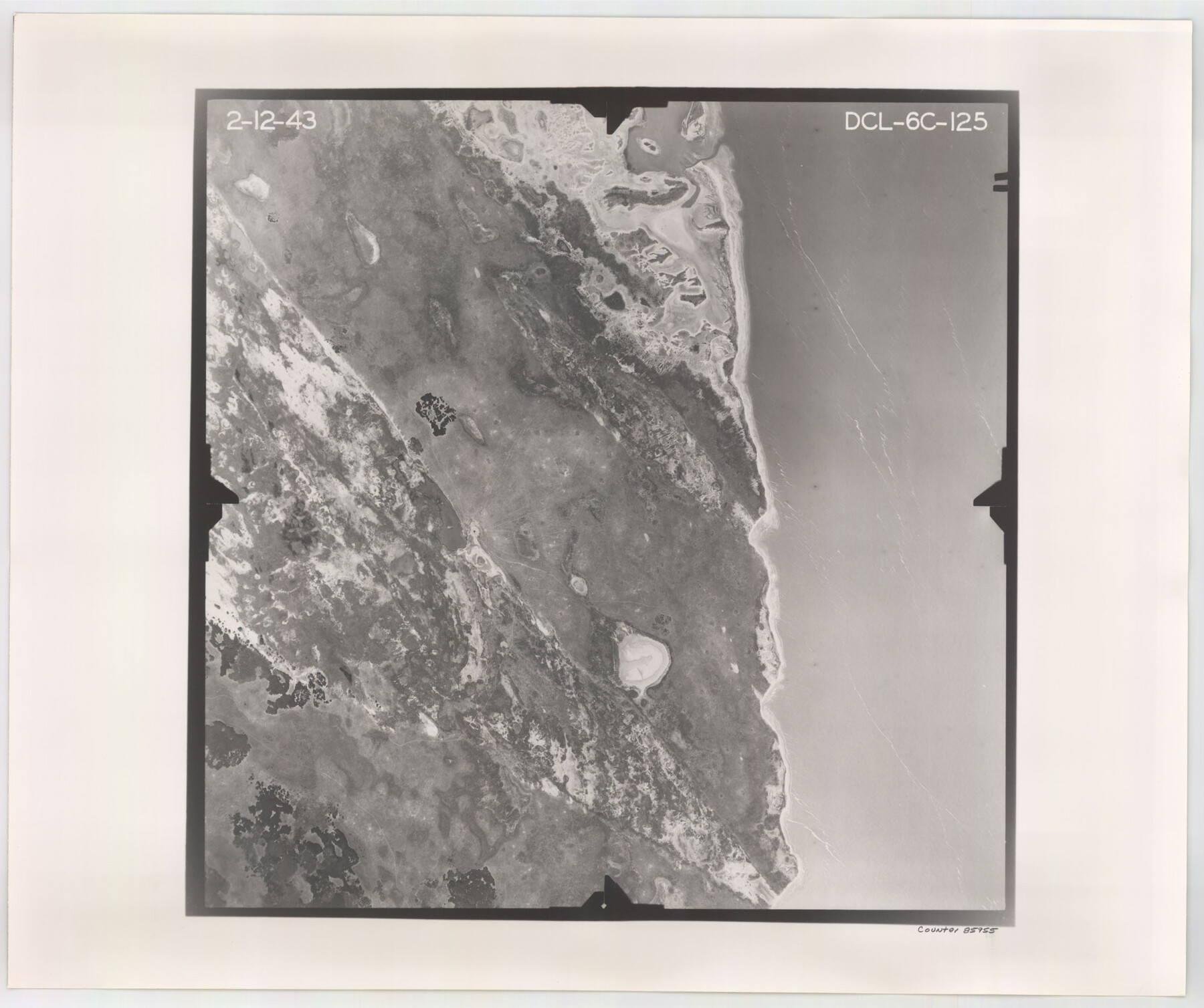
Flight Mission No. DCL-6C, Frame 125, Kenedy County
DCL-6C-125
-
Map/Doc
85955
-
Collection
General Map Collection
-
Object Dates
1943/2/12 (Creation Date)
-
People and Organizations
U. S. Department of Agriculture (Publisher)
-
Counties
Kenedy
-
Subjects
Aerial Photograph
-
Height x Width
18.7 x 22.3 inches
47.5 x 56.6 cm
-
Comments
Flown by Aerial Surveys of Pittsburgh, Inc. of Pittsburgh, Pennsylvania.
Part of: General Map Collection
Flight Mission No. BQY-15M, Frame 7, Harris County

Print $20.00
- Digital $50.00
Flight Mission No. BQY-15M, Frame 7, Harris County
1953
Size 18.5 x 22.4 inches
Map/Doc 85305
Matagorda County Sketch File 16

Print $4.00
- Digital $50.00
Matagorda County Sketch File 16
Size 8.4 x 10.3 inches
Map/Doc 30780
Lampasas County Rolled Sketch 4

Print $20.00
- Digital $50.00
Lampasas County Rolled Sketch 4
2001
Size 27.1 x 38.5 inches
Map/Doc 6566
Austin County Sketch File 7

Print $40.00
- Digital $50.00
Austin County Sketch File 7
1894
Size 18.8 x 15.7 inches
Map/Doc 10872
Leon County Working Sketch 1

Print $20.00
- Digital $50.00
Leon County Working Sketch 1
Size 16.1 x 18.7 inches
Map/Doc 70400
Motley County Sketch File 7a (S)

Print $5.00
- Digital $50.00
Motley County Sketch File 7a (S)
1895
Size 9.6 x 8.8 inches
Map/Doc 32151

Stonewall County Boundary File 4b

Print $18.00
- Digital $50.00
Stonewall County Boundary File 4b
Size 9.1 x 8.8 inches
Map/Doc 58993
Flight Mission No. DCL-6C, Frame 71, Kenedy County

Print $20.00
- Digital $50.00
Flight Mission No. DCL-6C, Frame 71, Kenedy County
1943
Size 18.6 x 22.3 inches
Map/Doc 85913
Right of Way and Track Map International & Gt Northern Ry. operated by the International & Gt. Northern Ry. Co., San Antonio Division

Print $40.00
- Digital $50.00
Right of Way and Track Map International & Gt Northern Ry. operated by the International & Gt. Northern Ry. Co., San Antonio Division
1917
Size 25.6 x 58.1 inches
Map/Doc 64587
Pecos County Working Sketch 34

Print $20.00
- Digital $50.00
Pecos County Working Sketch 34
1939
Size 32.7 x 27.6 inches
Map/Doc 71506
[Map of Sabine County]
![4009, [Map of Sabine County], General Map Collection](https://historictexasmaps.com/wmedia_w700/maps/4009.tif.jpg)
Print $20.00
- Digital $50.00
[Map of Sabine County]
1839
Size 23.9 x 18.9 inches
Map/Doc 4009
You may also like
[Sketch of part of G. & M. Block 5, G. & M. Block 4, Block M19 and Block 21W]
![93081, [Sketch of part of G. & M. Block 5, G. & M. Block 4, Block M19 and Block 21W], Twichell Survey Records](https://historictexasmaps.com/wmedia_w700/maps/93081-1.tif.jpg)
Print $20.00
- Digital $50.00
[Sketch of part of G. & M. Block 5, G. & M. Block 4, Block M19 and Block 21W]
Size 21.7 x 16.6 inches
Map/Doc 93081
Schleicher County Rolled Sketch 27

Print $20.00
- Digital $50.00
Schleicher County Rolled Sketch 27
Size 37.4 x 43.3 inches
Map/Doc 9909
Real County Working Sketch 78

Print $20.00
- Digital $50.00
Real County Working Sketch 78
1980
Size 33.9 x 35.5 inches
Map/Doc 71970
Railroad and County Map of Texas

Print $20.00
- Digital $50.00
Railroad and County Map of Texas
1908
Size 42.7 x 44.7 inches
Map/Doc 2141
Duval County Boundary File 3j

Print $12.00
- Digital $50.00
Duval County Boundary File 3j
Size 12.8 x 8.0 inches
Map/Doc 52753
Flight Mission No. DAG-21K, Frame 92, Matagorda County

Print $20.00
- Digital $50.00
Flight Mission No. DAG-21K, Frame 92, Matagorda County
1952
Size 18.5 x 22.4 inches
Map/Doc 86421
Atascosa County Sketch File 21

Print $40.00
- Digital $50.00
Atascosa County Sketch File 21
Size 20.0 x 19.8 inches
Map/Doc 10859
[Part of H. & G. N. Blocks 2 and D-13]
![90490, [Part of H. & G. N. Blocks 2 and D-13], Twichell Survey Records](https://historictexasmaps.com/wmedia_w700/maps/90490-1.tif.jpg)
Print $20.00
- Digital $50.00
[Part of H. & G. N. Blocks 2 and D-13]
1907
Size 14.1 x 17.7 inches
Map/Doc 90490
Interfaith's Official Map: The Woodlands, a real hometown for people and companies

Interfaith's Official Map: The Woodlands, a real hometown for people and companies
1997
Size 22.4 x 36.5 inches
Map/Doc 94286
Brooks County Sketch File 1

Print $12.00
- Digital $50.00
Brooks County Sketch File 1
1923
Size 14.3 x 8.9 inches
Map/Doc 16537
Liberty County Sketch File 28

Print $6.00
- Digital $50.00
Liberty County Sketch File 28
Size 5.2 x 8.0 inches
Map/Doc 29952
Guadalupe County Sketch File 21

Print $6.00
- Digital $50.00
Guadalupe County Sketch File 21
Size 9.9 x 8.5 inches
Map/Doc 24702