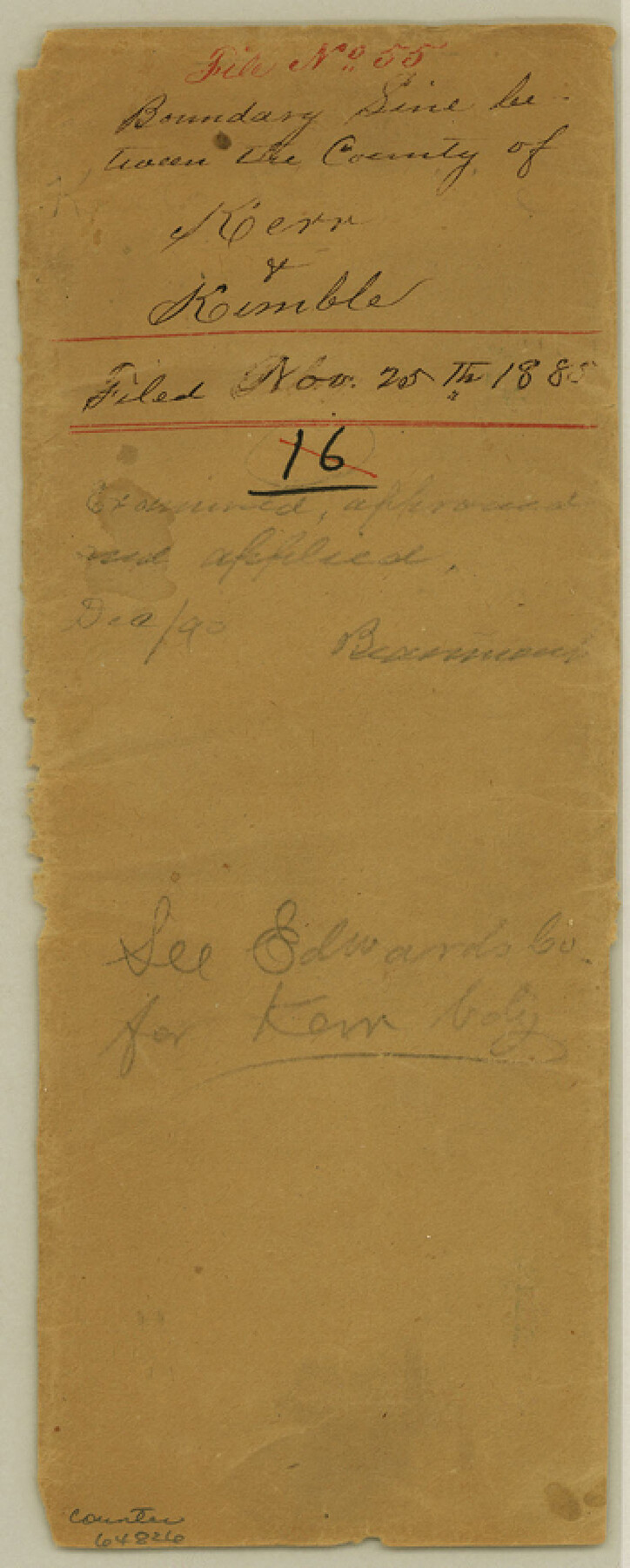
Kerr County Boundary File 55
Report of Survey Kerr & Kimble Co. Bdy. Lines
-
Map/Doc
64826
-
Collection
General Map Collection
-
Counties
Kerr
-
Subjects
County Boundaries
-
Height x Width
8.7 x 3.5 inches
22.1 x 8.9 cm
Part of: General Map Collection
Gaines County Working Sketch 36

Print $20.00
- Digital $50.00
Gaines County Working Sketch 36
Size 23.5 x 36.7 inches
Map/Doc 69336
Map of Travis County

Print $20.00
- Digital $50.00
Map of Travis County
1875
Size 20.6 x 26.4 inches
Map/Doc 4093
Panola County Working Sketch 31

Print $20.00
- Digital $50.00
Panola County Working Sketch 31
1981
Map/Doc 71440
Ward County Rolled Sketch 24C

Print $40.00
- Digital $50.00
Ward County Rolled Sketch 24C
1967
Size 54.8 x 24.4 inches
Map/Doc 10114
Colorado County Working Sketch 9

Print $20.00
- Digital $50.00
Colorado County Working Sketch 9
1939
Size 12.0 x 15.7 inches
Map/Doc 68109
Nueces County NRC Article 33.136 Sketch 5

Print $48.00
- Digital $50.00
Nueces County NRC Article 33.136 Sketch 5
2002
Size 22.9 x 34.7 inches
Map/Doc 78666
Shackelford County Sketch File 6

Print $20.00
- Digital $50.00
Shackelford County Sketch File 6
Size 14.8 x 24.5 inches
Map/Doc 81981
Duval County Rolled Sketch 44

Print $20.00
- Digital $50.00
Duval County Rolled Sketch 44
Size 21.2 x 26.5 inches
Map/Doc 8822
Shelby County Rolled Sketch 14

Print $20.00
- Digital $50.00
Shelby County Rolled Sketch 14
1948
Size 33.1 x 25.9 inches
Map/Doc 7782
Edwards County Working Sketch 13

Print $20.00
- Digital $50.00
Edwards County Working Sketch 13
1922
Size 18.3 x 18.4 inches
Map/Doc 68889
Upshur County Sketch File 22

Print $8.00
- Digital $50.00
Upshur County Sketch File 22
2015
Size 11.0 x 8.5 inches
Map/Doc 93774
Val Verde County Working Sketch 103

Print $20.00
- Digital $50.00
Val Verde County Working Sketch 103
1981
Size 37.1 x 39.9 inches
Map/Doc 72238
You may also like
[Sketch showing area around Runnels County School Land, Yates survey 34 1/2 and Runnels County School Land]
![91683, [Sketch showing area around Runnels County School Land, Yates survey 34 1/2 and Runnels County School Land], Twichell Survey Records](https://historictexasmaps.com/wmedia_w700/maps/91683-1.tif.jpg)
Print $20.00
- Digital $50.00
[Sketch showing area around Runnels County School Land, Yates survey 34 1/2 and Runnels County School Land]
Size 17.5 x 12.5 inches
Map/Doc 91683
Flight Mission No. CRE-1R, Frame 122, Jackson County

Print $20.00
- Digital $50.00
Flight Mission No. CRE-1R, Frame 122, Jackson County
1956
Size 16.2 x 16.0 inches
Map/Doc 85333
Hood County Sketch File 19

Print $11.00
- Digital $50.00
Hood County Sketch File 19
Size 9.0 x 7.9 inches
Map/Doc 26603
2008 Official Travel Map Texas

Digital $50.00
2008 Official Travel Map Texas
Size 33.5 x 36.4 inches
Map/Doc 94309
List of County School Lands

Print $20.00
- Digital $50.00
List of County School Lands
Size 17.7 x 23.2 inches
Map/Doc 65797
Red River, Bois D'Arc Creek Floodway Sheet No. 1

Print $20.00
- Digital $50.00
Red River, Bois D'Arc Creek Floodway Sheet No. 1
1915
Size 28.8 x 25.9 inches
Map/Doc 69656
Val Verde County Working Sketch 20

Print $20.00
- Digital $50.00
Val Verde County Working Sketch 20
1929
Size 30.5 x 20.2 inches
Map/Doc 72155
Pressler's Map of Texas

Print $2.00
- Digital $50.00
Pressler's Map of Texas
1867
Size 9.0 x 6.0 inches
Map/Doc 93920
Hood County Sketch File 29 and 29A

Print $26.00
- Digital $50.00
Hood County Sketch File 29 and 29A
1997
Size 26.3 x 35.2 inches
Map/Doc 11783
Calhoun County Rolled Sketch 14

Print $20.00
- Digital $50.00
Calhoun County Rolled Sketch 14
Size 22.1 x 40.6 inches
Map/Doc 5460
Upshur County Sketch File 13A

Print $20.00
- Digital $50.00
Upshur County Sketch File 13A
1936
Size 20.5 x 32.4 inches
Map/Doc 12503
Comal County Sketch File 15

Print $6.00
- Digital $50.00
Comal County Sketch File 15
Size 10.3 x 8.6 inches
Map/Doc 19031