Hood County Sketch File 29 and 29A
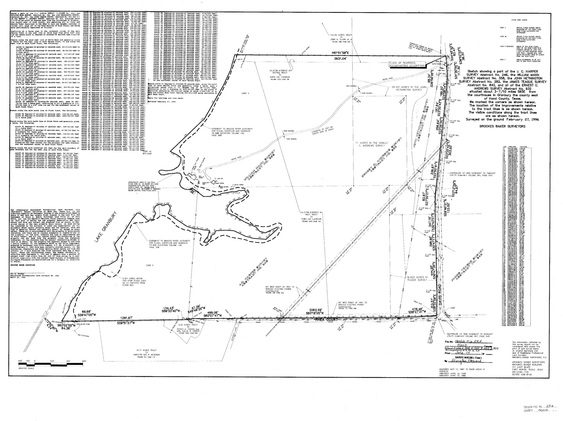
[Sketch and report regarding a part of the J.C. Harper survey A-246, the William Mann survey A-358, the John Hethington survey A-282, the James Teague survey A-842, and all of the Ernest C. Andrews survey A-932]
-
Map/Doc
11783
-
Collection
General Map Collection
-
Object Dates
6/9/1997 (Creation Date)
6/10/1997 (File Date)
2/27/1996 (Survey Date)
11/20/1851 (Survey Date)
2/20/1858 (Survey Date)
12/6/1858 (Survey Date)
12/30/1870 (Survey Date)
1/6/1871 (Survey Date)
8/12/1872 (Survey Date)
10/15/1872 (Survey Date)
2/17/1897 (Survey Date)
5/25/1901 (Survey Date)
-
People and Organizations
Don W. Hickey (Surveyor/Engineer)
-
Counties
Hood
-
Subjects
Surveying Sketch File
-
Height x Width
26.3 x 35.2 inches
66.8 x 89.4 cm
-
Medium
multi-page, multi-format
-
Comments
See Hood County Rolled Sketch 6 (6222) and Hood County Rolled Sketch 6A (6223) for related sketches.
-
Features
Lake Granbury
Brazos River
Related maps
Hood County Rolled Sketch 6

Print $20.00
- Digital $50.00
Hood County Rolled Sketch 6
Size 20.4 x 26.5 inches
Map/Doc 6222
Hood County Rolled Sketch 6A

Print $4.00
- Digital $50.00
Hood County Rolled Sketch 6A
1996
Size 19.9 x 26.5 inches
Map/Doc 6223
Part of: General Map Collection
Comanche County Sketch File 13

Print $4.00
- Digital $50.00
Comanche County Sketch File 13
Size 8.5 x 8.6 inches
Map/Doc 19076
Flight Mission No. BRA-3M, Frame 194, Jefferson County

Print $20.00
- Digital $50.00
Flight Mission No. BRA-3M, Frame 194, Jefferson County
1953
Size 18.8 x 22.4 inches
Map/Doc 85409
Flight Mission No. BRA-7M, Frame 183, Jefferson County

Print $20.00
- Digital $50.00
Flight Mission No. BRA-7M, Frame 183, Jefferson County
1953
Size 18.6 x 22.3 inches
Map/Doc 85551
Motley County Boundary File 2a

Print $20.00
- Digital $50.00
Motley County Boundary File 2a
Size 14.3 x 8.6 inches
Map/Doc 57511
Burnet County Working Sketch 21

Print $20.00
- Digital $50.00
Burnet County Working Sketch 21
1983
Size 47.6 x 28.4 inches
Map/Doc 67864
Railroad Track Map, H&TCRRCo., Falls County, Texas

Print $4.00
- Digital $50.00
Railroad Track Map, H&TCRRCo., Falls County, Texas
1918
Size 11.5 x 18.5 inches
Map/Doc 62856
Duval County Rolled Sketch 18

Print $20.00
- Digital $50.00
Duval County Rolled Sketch 18
1940
Size 23.7 x 23.0 inches
Map/Doc 5739

Brewster County Working Sketch 11

Print $20.00
- Digital $50.00
Brewster County Working Sketch 11
1919
Size 18.2 x 17.9 inches
Map/Doc 67544
Map of the Rio Grande & Eagle Pass Ry. from Sections 1-6 Inclusive, Webb County

Print $40.00
- Digital $50.00
Map of the Rio Grande & Eagle Pass Ry. from Sections 1-6 Inclusive, Webb County
1909
Size 25.4 x 55.7 inches
Map/Doc 64655
McCulloch County Working Sketch 12

Print $20.00
- Digital $50.00
McCulloch County Working Sketch 12
1982
Size 37.5 x 20.1 inches
Map/Doc 70687
Karnes County Working Sketch 6

Print $20.00
- Digital $50.00
Karnes County Working Sketch 6
1961
Size 23.3 x 27.5 inches
Map/Doc 66654
You may also like
Flight Mission No. DIX-6P, Frame 114, Aransas County

Print $20.00
- Digital $50.00
Flight Mission No. DIX-6P, Frame 114, Aransas County
1956
Size 19.1 x 23.0 inches
Map/Doc 83820
Comanche County Rolled Sketch 1

Print $20.00
- Digital $50.00
Comanche County Rolled Sketch 1
1985
Size 24.1 x 18.7 inches
Map/Doc 5542
Panola County Rolled Sketch 3

Print $1246.00
- Digital $50.00
Panola County Rolled Sketch 3
1949
Size 10.3 x 15.2 inches
Map/Doc 47978
Crockett County Sketch File F

Print $20.00
- Digital $50.00
Crockett County Sketch File F
1907
Size 26.3 x 15.7 inches
Map/Doc 11240
Flight Mission No. BRA-7M, Frame 148, Jefferson County

Print $20.00
- Digital $50.00
Flight Mission No. BRA-7M, Frame 148, Jefferson County
1953
Size 18.6 x 22.4 inches
Map/Doc 85542
Hutchinson County Working Sketch 17

Print $40.00
- Digital $50.00
Hutchinson County Working Sketch 17
1955
Size 47.2 x 128.6 inches
Map/Doc 66375
Bosque County Working Sketch Graphic Index

Print $20.00
- Digital $50.00
Bosque County Working Sketch Graphic Index
1945
Size 46.9 x 36.5 inches
Map/Doc 76469
Gonzales County Working Sketch Graphic Index

Print $40.00
- Digital $50.00
Gonzales County Working Sketch Graphic Index
1986
Size 40.2 x 53.0 inches
Map/Doc 76556
Webb County Sketch File 25

Print $20.00
- Digital $50.00
Webb County Sketch File 25
1936
Size 18.2 x 30.7 inches
Map/Doc 12639
Jefferson County Rolled Sketch 43

Print $40.00
- Digital $50.00
Jefferson County Rolled Sketch 43
1957
Size 50.1 x 18.2 inches
Map/Doc 9303
[Beaty and Moulton Block A, Southern Pacific Railroad Block 2]
![91398, [Beaty and Moulton Block A, Southern Pacific Railroad Block 2], Twichell Survey Records](https://historictexasmaps.com/wmedia_w700/maps/91398-1.tif.jpg)
Print $20.00
- Digital $50.00
[Beaty and Moulton Block A, Southern Pacific Railroad Block 2]
1914
Size 24.2 x 15.4 inches
Map/Doc 91398
Cherokee County Working Sketch 23

Print $20.00
- Digital $50.00
Cherokee County Working Sketch 23
1972
Size 44.4 x 46.9 inches
Map/Doc 67978