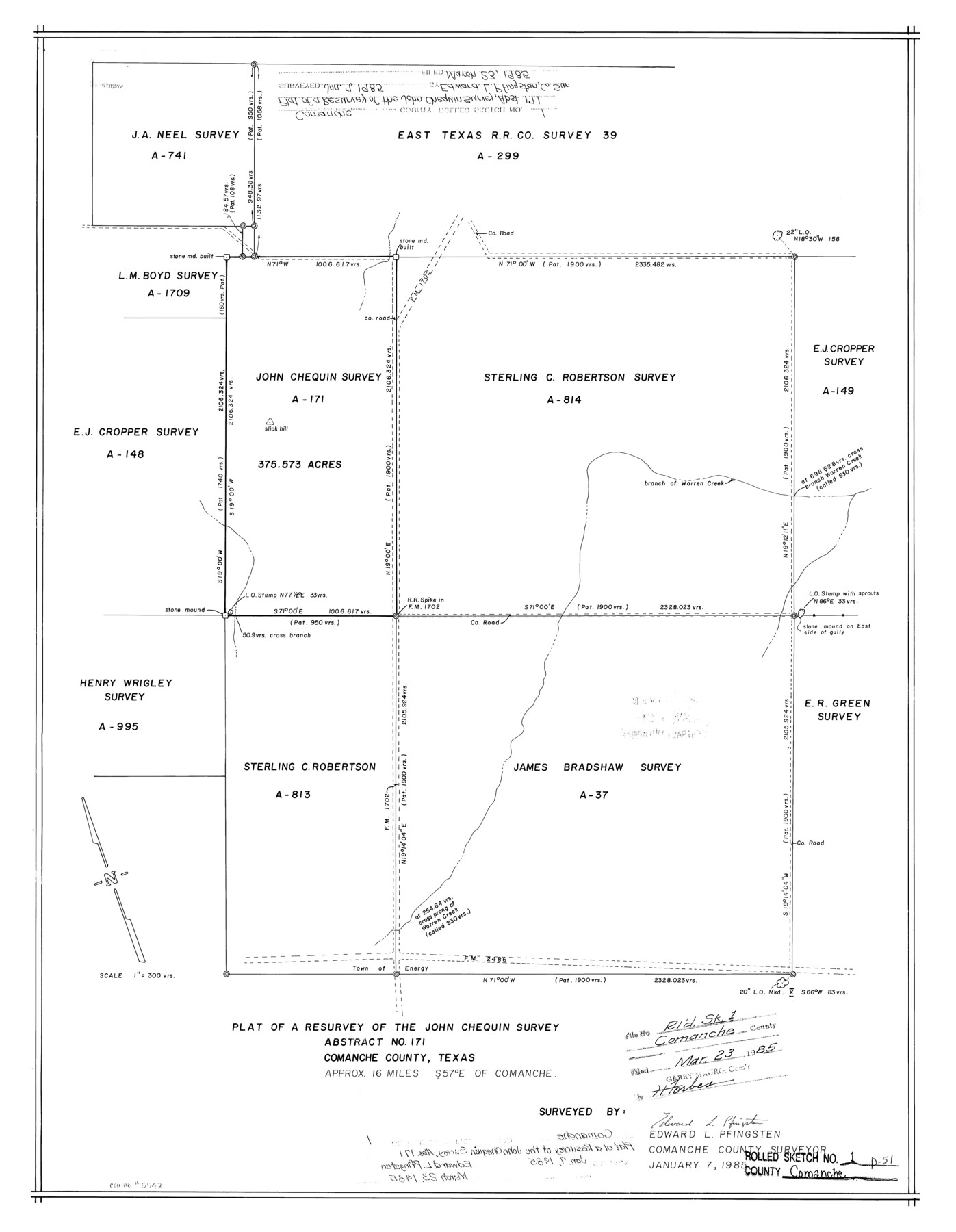
Comanche County Rolled Sketch 1
Plat of a resurvey of the John Chequin survey abstract no. 171, Comanche County, Texas
-
Map/Doc
5542
-
Collection
General Map Collection
-
Object Dates
1985/1/7 (Creation Date)
1985/3/23 (File Date)
-
People and Organizations
Edward L. Pfingsten (Surveyor/Engineer)
-
Counties
Comanche
-
Subjects
Surveying Rolled Sketch
-
Height x Width
24.1 x 18.7 inches
61.2 x 47.5 cm
-
Scale
1" = 300 varas
Part of: General Map Collection
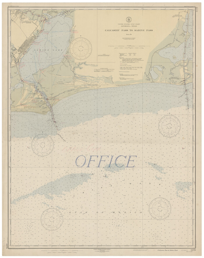
Calcasieu Pass to Sabine Pass
Print $20.00
- Digital $50.00
Calcasieu Pass to Sabine Pass
1946
Size 45.0 x 35.7 inches
Map/Doc 69807
Supplemental Plat, T. 4S., R. 14W., Indian Meridian, Oklahoma

Print $4.00
- Digital $50.00
Supplemental Plat, T. 4S., R. 14W., Indian Meridian, Oklahoma
1926
Size 18.1 x 23.6 inches
Map/Doc 75149
Brooks County Working Sketch 17

Print $20.00
- Digital $50.00
Brooks County Working Sketch 17
1980
Size 38.2 x 27.7 inches
Map/Doc 67801
Stonewall County Working Sketch 18

Print $20.00
- Digital $50.00
Stonewall County Working Sketch 18
1956
Size 24.0 x 21.6 inches
Map/Doc 62325
Gray County Rolled Sketch A

Print $20.00
- Digital $50.00
Gray County Rolled Sketch A
1888
Size 40.4 x 40.8 inches
Map/Doc 9008
El Paso County Rolled Sketch 42

Print $20.00
- Digital $50.00
El Paso County Rolled Sketch 42
Size 34.5 x 24.5 inches
Map/Doc 5828
Bell County Sketch File 28

Print $4.00
- Digital $50.00
Bell County Sketch File 28
1870
Size 7.8 x 6.5 inches
Map/Doc 14437
Henderson County Rolled Sketch 13

Print $20.00
- Digital $50.00
Henderson County Rolled Sketch 13
1987
Size 25.3 x 21.0 inches
Map/Doc 6205
Sabine River, Dixon Sheet/Cowleach Fork of the Sabine River

Print $20.00
- Digital $50.00
Sabine River, Dixon Sheet/Cowleach Fork of the Sabine River
1935
Size 44.0 x 18.5 inches
Map/Doc 65145
Val Verde County Rolled Sketch 51

Print $40.00
- Digital $50.00
Val Verde County Rolled Sketch 51
1937
Size 29.4 x 48.4 inches
Map/Doc 10075
Webb County Working Sketch 33

Print $20.00
- Digital $50.00
Webb County Working Sketch 33
1938
Size 27.4 x 35.9 inches
Map/Doc 72398

You may also like
Val Verde County Sketch File F

Print $42.00
- Digital $50.00
Val Verde County Sketch File F
1906
Size 40.1 x 16.9 inches
Map/Doc 10423
Swisher County Rolled Sketch 7

Print $40.00
- Digital $50.00
Swisher County Rolled Sketch 7
1955
Size 65.0 x 43.5 inches
Map/Doc 9983
Texas Intracoastal Waterway - Laguna Madre - Dagger Hill to Potrero Grande

Print $20.00
- Digital $50.00
Texas Intracoastal Waterway - Laguna Madre - Dagger Hill to Potrero Grande
1956
Size 38.6 x 27.2 inches
Map/Doc 73509
Map of Dallas County

Print $20.00
- Digital $50.00
Map of Dallas County
1871
Size 22.1 x 18.7 inches
Map/Doc 3463
Plan of the cities of Denver, Auraria and Highland, Jefferson Terr.

Print $20.00
- Digital $50.00
Plan of the cities of Denver, Auraria and Highland, Jefferson Terr.
1859
Size 23.7 x 29.8 inches
Map/Doc 94053
Flight Mission No. DQN-2K, Frame 89, Calhoun County

Print $20.00
- Digital $50.00
Flight Mission No. DQN-2K, Frame 89, Calhoun County
1953
Size 16.2 x 15.7 inches
Map/Doc 84279
Trace of a copy of the map captured at the battle of Resaca de la Palma

Print $20.00
- Digital $50.00
Trace of a copy of the map captured at the battle of Resaca de la Palma
Size 18.3 x 27.3 inches
Map/Doc 73054
Map of Texas in 1836

Print $20.00
- Digital $50.00
Map of Texas in 1836
1936
Size 32.1 x 24.4 inches
Map/Doc 2110
United States - Gulf Coast Texas - Southern part of Laguna Madre

Print $20.00
- Digital $50.00
United States - Gulf Coast Texas - Southern part of Laguna Madre
1941
Size 27.0 x 18.3 inches
Map/Doc 72953
Tyler County Sketch File 5

Print $20.00
- Digital $50.00
Tyler County Sketch File 5
1854
Size 13.2 x 17.4 inches
Map/Doc 12497
Glasscock County Sketch File 25

Print $20.00
- Digital $50.00
Glasscock County Sketch File 25
1951
Size 28.8 x 20.6 inches
Map/Doc 11566
Current Miscellaneous File 52

Print $12.00
- Digital $50.00
Current Miscellaneous File 52
1953
Size 12.3 x 9.3 inches
Map/Doc 74032