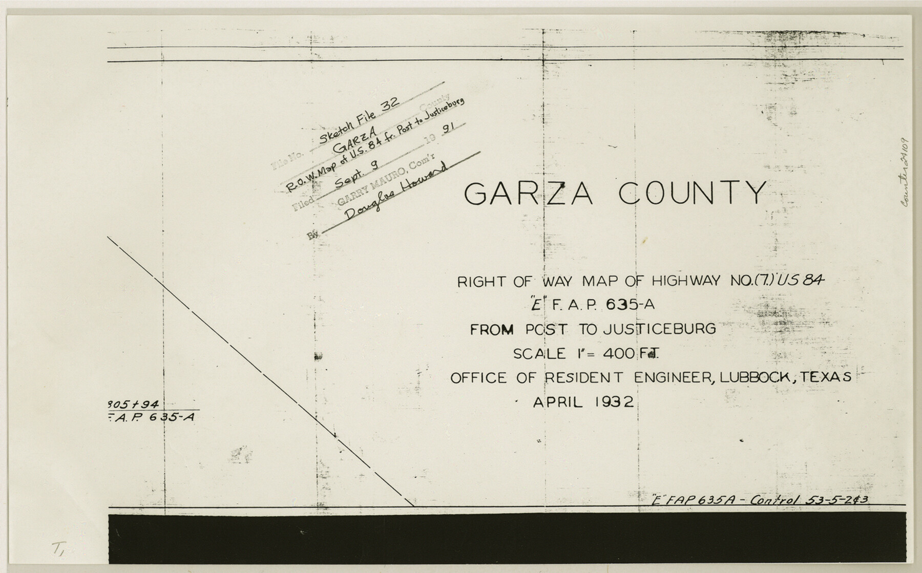
Garza County Sketch File 32
[R.O.W. map of US-84 from Post to Justiceburg]
-
Map/Doc
24109
-
Collection
General Map Collection
-
Object Dates
1932 (Creation Date)
1991/9/9 (File Date)
-
People and Organizations
Texas Highway Department (Surveyor/Engineer)
-
Counties
Garza
-
Subjects
Surveying Sketch File
-
Height x Width
8.9 x 14.3 inches
22.6 x 36.3 cm
-
Medium
paper, photocopy
-
Scale
1:400
-
Features
Second Street
H Street
G Street
F Street
E Street
D Street
C Street
B Street
Main Street
Highway No. 7 U.S. 84
Fourth Street
Sixth Street
Tenth Street
Twelfth Street
Railroad line to Slaton
P&SF
Justiceburg
Post
Part of: General Map Collection
Kimble County Working Sketch 87

Print $20.00
- Digital $50.00
Kimble County Working Sketch 87
1974
Size 24.1 x 30.0 inches
Map/Doc 70155
Llano County Rolled Sketch 1

Print $20.00
- Digital $50.00
Llano County Rolled Sketch 1
1961
Size 43.9 x 30.3 inches
Map/Doc 9458
Bandera County Working Sketch 6

Print $20.00
- Digital $50.00
Bandera County Working Sketch 6
1917
Size 14.2 x 14.3 inches
Map/Doc 67599
Kimble County Sketch File A1

Print $4.00
- Digital $50.00
Kimble County Sketch File A1
Size 8.8 x 13.4 inches
Map/Doc 28961
Newton County Rolled Sketch 6

Print $20.00
- Digital $50.00
Newton County Rolled Sketch 6
Size 24.9 x 45.7 inches
Map/Doc 6842
Maps of Gulf Intracoastal Waterway, Texas - Sabine River to the Rio Grande and connecting waterways including ship channels

Print $20.00
- Digital $50.00
Maps of Gulf Intracoastal Waterway, Texas - Sabine River to the Rio Grande and connecting waterways including ship channels
1966
Size 14.6 x 22.2 inches
Map/Doc 61971
Visitor's Guide to Mexico City, D.F. [and Index to Cities and Villages and Route Summaries]
![96822, Visitor's Guide to Mexico City, D.F. [and Index to Cities and Villages and Route Summaries], General Map Collection](https://historictexasmaps.com/wmedia_w700/maps/96822.tif.jpg)
Visitor's Guide to Mexico City, D.F. [and Index to Cities and Villages and Route Summaries]
1999
Size 33.7 x 25.1 inches
Map/Doc 96822
Montgomery County Working Sketch 74

Print $20.00
- Digital $50.00
Montgomery County Working Sketch 74
1981
Size 37.6 x 45.6 inches
Map/Doc 71181
Jefferson County Sketch File 27

Print $6.00
- Digital $50.00
Jefferson County Sketch File 27
1901
Size 11.0 x 13.9 inches
Map/Doc 28191
Upton County Working Sketch 8

Print $20.00
- Digital $50.00
Upton County Working Sketch 8
1916
Size 21.9 x 16.8 inches
Map/Doc 69504
Concho County Sketch File 5

Print $2.00
- Digital $50.00
Concho County Sketch File 5
1858
Size 8.1 x 7.4 inches
Map/Doc 82974
[Corpus Christi Bay and Aransas Bay]
![144, [Corpus Christi Bay and Aransas Bay], General Map Collection](https://historictexasmaps.com/wmedia_w700/maps/144.tif.jpg)
Print $20.00
- Digital $50.00
[Corpus Christi Bay and Aransas Bay]
1840
Size 17.1 x 22.4 inches
Map/Doc 144
You may also like
Fort Bend County Working Sketch 25

Print $40.00
- Digital $50.00
Fort Bend County Working Sketch 25
1981
Size 43.7 x 65.9 inches
Map/Doc 69231
Van Zandt County Sketch File 10

Print $4.00
- Digital $50.00
Van Zandt County Sketch File 10
1858
Size 6.2 x 8.0 inches
Map/Doc 39395
Chambers County NRC Article 33.136 Sketch 4

Print $48.00
- Digital $50.00
Chambers County NRC Article 33.136 Sketch 4
2003
Size 18.2 x 24.3 inches
Map/Doc 78569
Flight Mission No. DQO-13T, Frame 49, Galveston County

Print $20.00
- Digital $50.00
Flight Mission No. DQO-13T, Frame 49, Galveston County
1958
Size 18.5 x 18.4 inches
Map/Doc 85214
Nacogdoches County Working Sketch 6

Print $20.00
- Digital $50.00
Nacogdoches County Working Sketch 6
1955
Size 14.7 x 12.5 inches
Map/Doc 71222
Galveston County Rolled Sketch 16

Print $20.00
- Digital $50.00
Galveston County Rolled Sketch 16
1952
Size 43.6 x 38.0 inches
Map/Doc 9078
Taylor County Sketch File 22

Print $189.00
- Digital $50.00
Taylor County Sketch File 22
1985
Size 14.6 x 8.9 inches
Map/Doc 37826
Dawson County, Texas

Print $20.00
- Digital $50.00
Dawson County, Texas
1880
Size 28.6 x 20.5 inches
Map/Doc 705
Flight Mission No. CRC-5R, Frame 38, Chambers County

Print $20.00
- Digital $50.00
Flight Mission No. CRC-5R, Frame 38, Chambers County
1956
Size 18.6 x 22.3 inches
Map/Doc 84957
La Salle County Working Sketch 51

Print $20.00
- Digital $50.00
La Salle County Working Sketch 51
1990
Size 33.9 x 29.9 inches
Map/Doc 70352
Winkler County Working Sketch 13

Print $20.00
- Digital $50.00
Winkler County Working Sketch 13
1961
Size 39.2 x 41.2 inches
Map/Doc 72607
Flight Mission No. CGI-3N, Frame 102, Cameron County

Print $20.00
- Digital $50.00
Flight Mission No. CGI-3N, Frame 102, Cameron County
1954
Size 18.6 x 22.2 inches
Map/Doc 84582