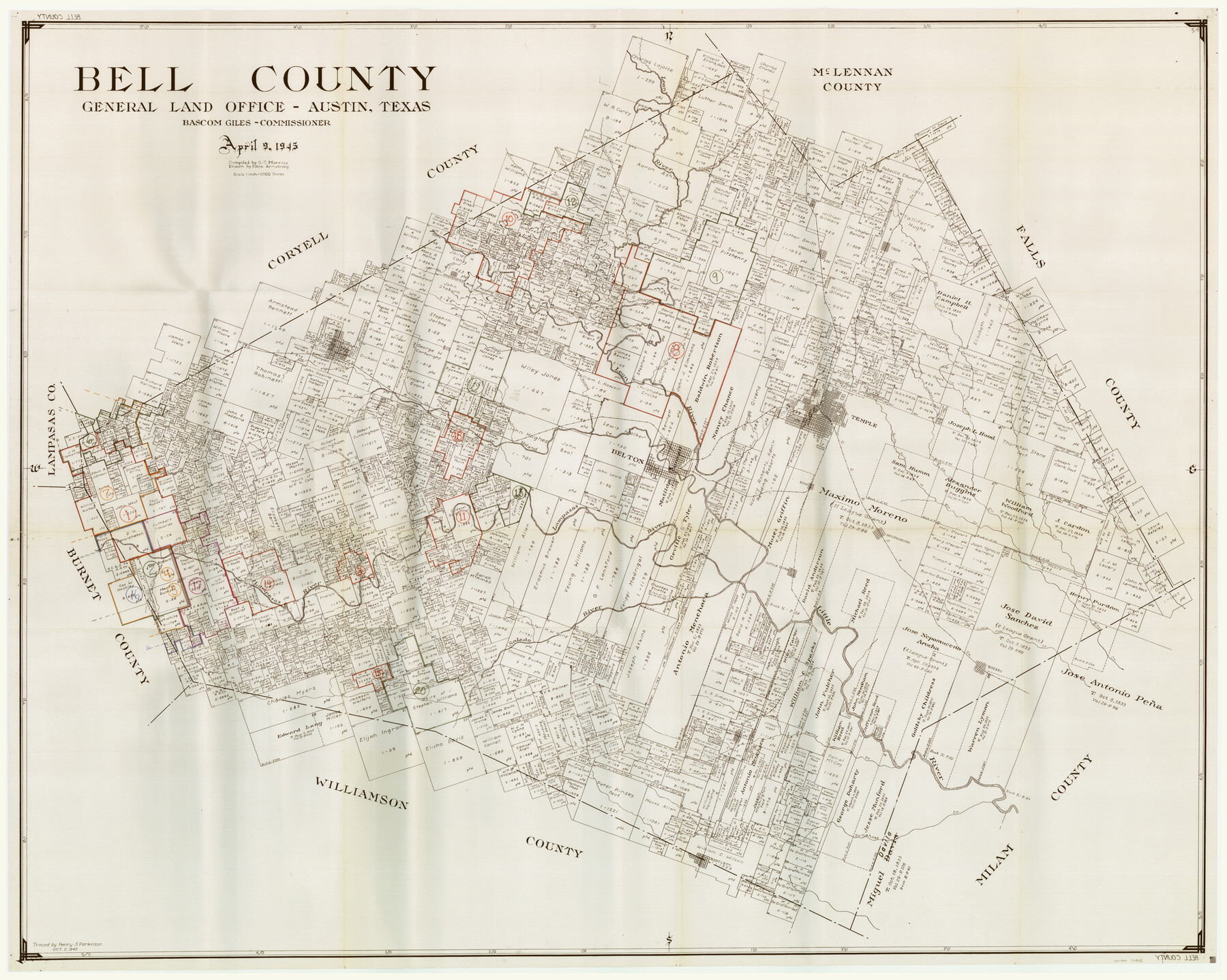
Bell County Working Sketch Graphic Index
-
Map/Doc
76465
-
Collection
General Map Collection
-
Object Dates
4/9/1945 (Creation Date)
-
People and Organizations
G.C. Morriss (Compiler)
Eltea Armstrong (Draftsman)
-
Counties
Bell
-
Subjects
County Surveying Working Sketch
-
Height x Width
42.6 x 52.8 inches
108.2 x 134.1 cm
-
Scale
1" = 2000 varas
Part of: General Map Collection
[The S.K. Ry. of Texas, State Line to Pecos, Reeves Co., Texas]
![64161, [The S.K. Ry. of Texas, State Line to Pecos, Reeves Co., Texas], General Map Collection](https://historictexasmaps.com/wmedia_w700/maps/64161.tif.jpg)
Print $40.00
- Digital $50.00
[The S.K. Ry. of Texas, State Line to Pecos, Reeves Co., Texas]
1910
Size 19.2 x 120.9 inches
Map/Doc 64161
Dallas County Working Sketch 2

Print $20.00
- Digital $50.00
Dallas County Working Sketch 2
1917
Size 18.2 x 19.0 inches
Map/Doc 68568
Wilbarger County Sketch File 14

Print $4.00
- Digital $50.00
Wilbarger County Sketch File 14
1885
Size 14.2 x 8.7 inches
Map/Doc 40203
Jeff Davis County Working Sketch 20

Print $40.00
- Digital $50.00
Jeff Davis County Working Sketch 20
1957
Size 63.0 x 32.8 inches
Map/Doc 66515
Sabine River, Composite Sheet

Print $40.00
- Digital $50.00
Sabine River, Composite Sheet
Size 38.5 x 52.7 inches
Map/Doc 65133
Duval County Sketch File 26

Print $4.00
- Digital $50.00
Duval County Sketch File 26
1882
Size 13.0 x 9.0 inches
Map/Doc 21332
Coke County Sketch File 28

Print $20.00
- Digital $50.00
Coke County Sketch File 28
1886
Size 36.4 x 26.5 inches
Map/Doc 11113
Aransas County Sketch File 6

Print $4.00
- Digital $50.00
Aransas County Sketch File 6
Size 8.2 x 10.7 inches
Map/Doc 13110
Goliad County Sketch File 38

Print $4.00
- Digital $50.00
Goliad County Sketch File 38
1859
Size 13.0 x 8.1 inches
Map/Doc 24338
Knox County Rolled Sketch 15

Print $40.00
- Digital $50.00
Knox County Rolled Sketch 15
1892
Size 21.9 x 54.8 inches
Map/Doc 10667
Caldwell County Sketch File 4a

Print $8.00
- Digital $50.00
Caldwell County Sketch File 4a
1898
Size 11.2 x 8.8 inches
Map/Doc 35835
Flight Mission No. BQR-5K, Frame 68, Brazoria County

Print $20.00
- Digital $50.00
Flight Mission No. BQR-5K, Frame 68, Brazoria County
1952
Size 18.8 x 22.5 inches
Map/Doc 84013
You may also like
Flight Mission No. CUG-2P, Frame 21, Kleberg County

Print $20.00
- Digital $50.00
Flight Mission No. CUG-2P, Frame 21, Kleberg County
1956
Size 18.5 x 22.3 inches
Map/Doc 86185
Dimmit County Working Sketch 3

Print $20.00
- Digital $50.00
Dimmit County Working Sketch 3
1911
Size 16.5 x 22.5 inches
Map/Doc 68664
Bell County Sketch File 23

Print $4.00
- Digital $50.00
Bell County Sketch File 23
1873
Size 8.2 x 12.8 inches
Map/Doc 14414
Presidio County Rolled Sketch 140

Print $20.00
- Digital $50.00
Presidio County Rolled Sketch 140
2003
Size 44.4 x 34.7 inches
Map/Doc 78654
Stieler Map of 1879

Print $4.00
- Digital $50.00
Stieler Map of 1879
1879
Size 28.9 x 23.0 inches
Map/Doc 76055
Map of Jasper County

Print $20.00
- Digital $50.00
Map of Jasper County
1839
Size 40.2 x 28.8 inches
Map/Doc 78407
General Highway Map, Trinity County, Texas

Print $20.00
General Highway Map, Trinity County, Texas
1961
Size 18.1 x 24.5 inches
Map/Doc 79688
[Sketch in Edwards & Sutton Counties, Texas]
![4371, [Sketch in Edwards & Sutton Counties, Texas], Maddox Collection](https://historictexasmaps.com/wmedia_w700/maps/4371.tif.jpg)
Print $20.00
- Digital $50.00
[Sketch in Edwards & Sutton Counties, Texas]
Size 16.7 x 30.2 inches
Map/Doc 4371
Dawson County Working Sketch 5

Print $20.00
- Digital $50.00
Dawson County Working Sketch 5
1926
Size 22.3 x 26.1 inches
Map/Doc 68548
[Rand McNally's Indexed Map of Texas and Indian Territory]
![93992, [Rand McNally's Indexed Map of Texas and Indian Territory], Rees-Jones Digital Map Collection](https://historictexasmaps.com/wmedia_w700/maps/93992.tif.jpg)
Print $20.00
- Digital $50.00
[Rand McNally's Indexed Map of Texas and Indian Territory]
Size 26.0 x 20.6 inches
Map/Doc 93992
Foard County, Texas

Print $20.00
- Digital $50.00
Foard County, Texas
1891
Size 20.6 x 24.5 inches
Map/Doc 4338
Travis County Rolled Sketch 37

Print $20.00
- Digital $50.00
Travis County Rolled Sketch 37
1942
Size 36.1 x 35.6 inches
Map/Doc 10014