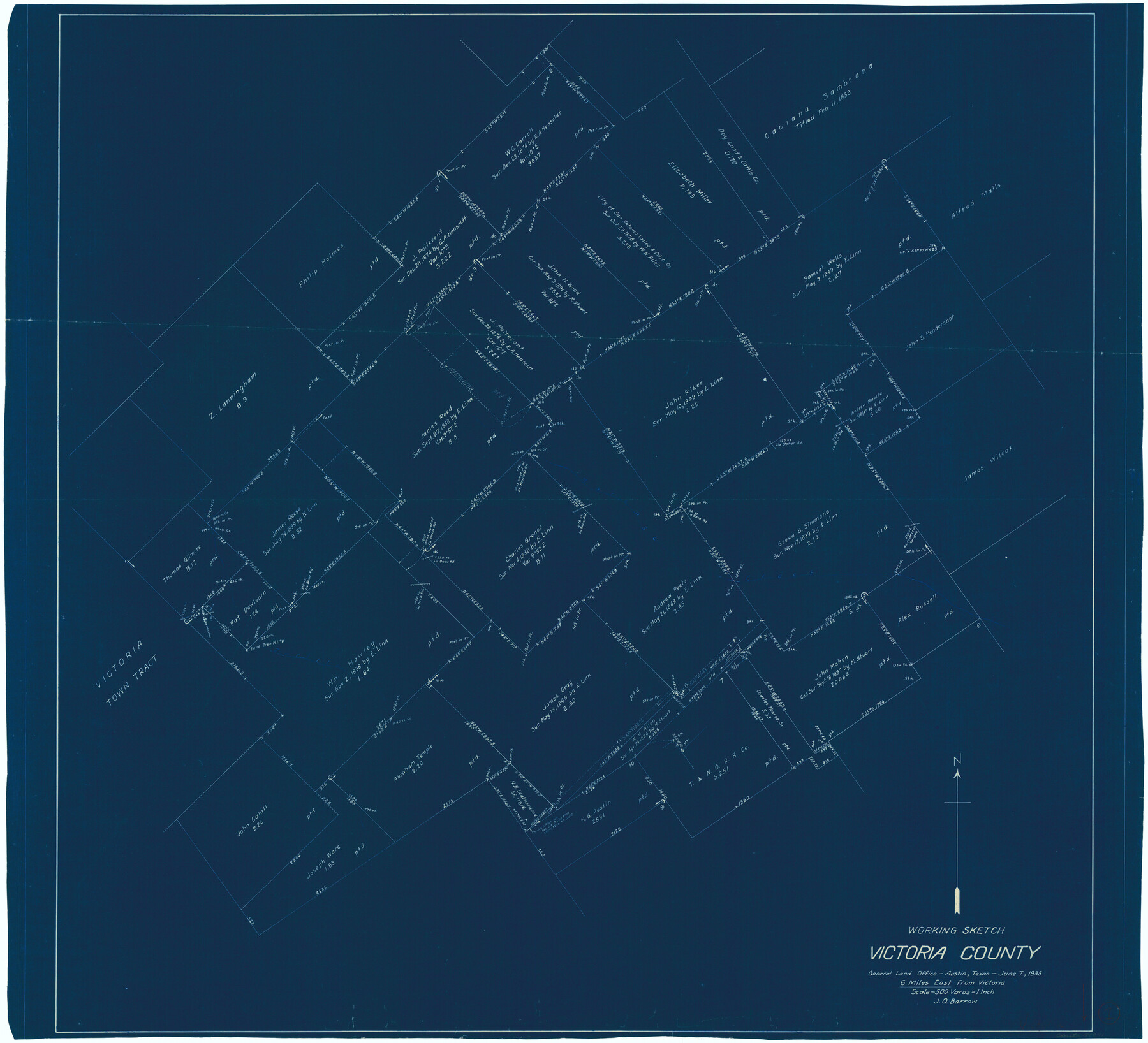
Victoria County Working Sketch 1
-
Map/Doc
72271
-
Collection
General Map Collection
-
Object Dates
6/7/1938 (Creation Date)
-
People and Organizations
J.O. Barrow (Draftsman)
-
Counties
Victoria
-
Subjects
Surveying Working Sketch
-
Height x Width
33.5 x 36.9 inches
85.1 x 93.7 cm
-
Scale
1" = 500 varas
Part of: General Map Collection
Jim Wells Co.

Print $20.00
- Digital $50.00
Jim Wells Co.
1913
Size 43.1 x 21.4 inches
Map/Doc 66886
Crane County Working Sketch 17

Print $20.00
- Digital $50.00
Crane County Working Sketch 17
1957
Size 10.7 x 37.0 inches
Map/Doc 63911
La Salle County Working Sketch 40

Print $20.00
- Digital $50.00
La Salle County Working Sketch 40
1968
Size 23.0 x 19.2 inches
Map/Doc 70341
Edwards County

Print $40.00
- Digital $50.00
Edwards County
1900
Size 56.3 x 59.5 inches
Map/Doc 66810
Burleson County Working Sketch 6

Print $20.00
- Digital $50.00
Burleson County Working Sketch 6
1980
Size 22.3 x 16.0 inches
Map/Doc 67725
United States - Gulf Coast - Galveston to Rio Grande

Print $20.00
- Digital $50.00
United States - Gulf Coast - Galveston to Rio Grande
1919
Size 27.2 x 18.2 inches
Map/Doc 72750
Map of the City of Kerens (Navarro County) Texas

Print $40.00
- Digital $50.00
Map of the City of Kerens (Navarro County) Texas
1958
Size 44.2 x 54.9 inches
Map/Doc 93670
Zavala County Sketch File 12

Print $54.00
- Digital $50.00
Zavala County Sketch File 12
1886
Size 9.0 x 7.7 inches
Map/Doc 41279
Brazoria County Sketch File 34

Print $4.00
- Digital $50.00
Brazoria County Sketch File 34
Size 14.3 x 8.9 inches
Map/Doc 15041
Galveston County Rolled Sketch 44

Print $20.00
- Digital $50.00
Galveston County Rolled Sketch 44
1991
Size 24.9 x 36.9 inches
Map/Doc 5973
Travis County Appraisal District Plat Map 3_1100

Print $20.00
- Digital $50.00
Travis County Appraisal District Plat Map 3_1100
Size 21.5 x 26.4 inches
Map/Doc 94212
San Patricio County NRC Article 33.136 Sketch 4A

Print $3.00
- Digital $50.00
San Patricio County NRC Article 33.136 Sketch 4A
Size 17.0 x 11.0 inches
Map/Doc 94696
You may also like
Jasper County Rolled Sketch 7A

Print $20.00
- Digital $50.00
Jasper County Rolled Sketch 7A
Size 22.4 x 14.7 inches
Map/Doc 6354
Comanche County Working Sketch 30

Print $20.00
- Digital $50.00
Comanche County Working Sketch 30
1988
Size 18.8 x 28.2 inches
Map/Doc 68164
Shelby County Rolled Sketch 2

Print $20.00
- Digital $50.00
Shelby County Rolled Sketch 2
Size 20.3 x 30.7 inches
Map/Doc 7775
Cooke County Working Sketch 1

Print $20.00
- Digital $50.00
Cooke County Working Sketch 1
Size 16.5 x 28.3 inches
Map/Doc 68238
Dickens County Rolled Sketch 12

Print $20.00
- Digital $50.00
Dickens County Rolled Sketch 12
1959
Size 33.5 x 39.7 inches
Map/Doc 8790
Baylor County Aerial Photograph Index Sheet 3

Print $20.00
- Digital $50.00
Baylor County Aerial Photograph Index Sheet 3
1950
Size 20.4 x 15.5 inches
Map/Doc 83665
Van Zandt County Sketch File 2a

Print $42.00
- Digital $50.00
Van Zandt County Sketch File 2a
Size 12.2 x 12.0 inches
Map/Doc 39363
Hemphill County Working Sketch 14

Print $20.00
- Digital $50.00
Hemphill County Working Sketch 14
1969
Size 34.0 x 44.8 inches
Map/Doc 66109
Stonewall County Sketch File 5

Print $40.00
- Digital $50.00
Stonewall County Sketch File 5
Size 14.9 x 14.4 inches
Map/Doc 37206
Bowie County Sketch File A

Print $40.00
- Digital $50.00
Bowie County Sketch File A
1902
Size 15.6 x 27.3 inches
Map/Doc 10946
United States - Gulf Coast - Galveston to Rio Grande

Print $20.00
- Digital $50.00
United States - Gulf Coast - Galveston to Rio Grande
1941
Size 26.7 x 18.5 inches
Map/Doc 72751
Wharton County Rolled Sketch 10

Print $20.00
- Digital $50.00
Wharton County Rolled Sketch 10
Size 21.9 x 32.8 inches
Map/Doc 8234