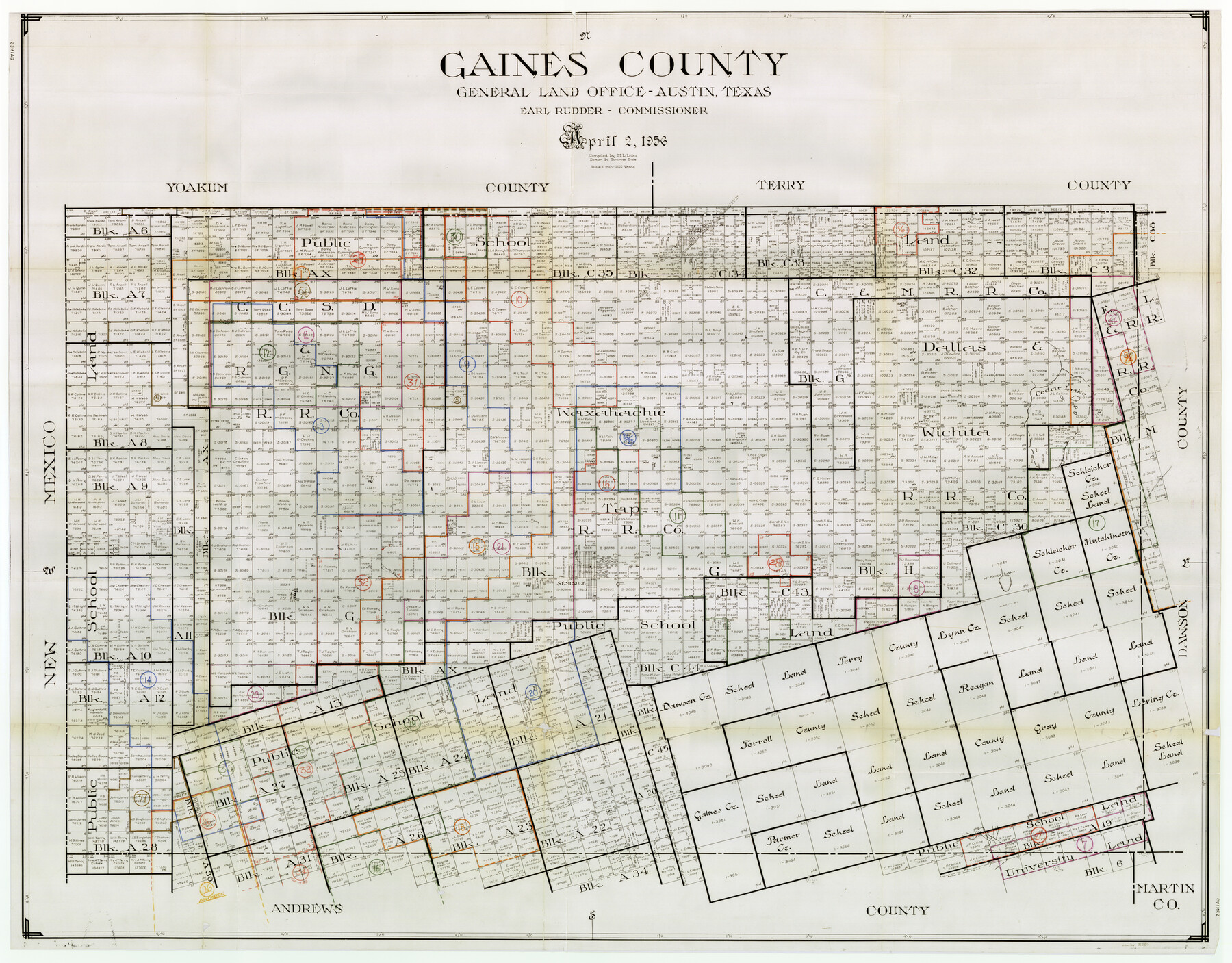
Gaines County Working Sketch Graphic Index
-
Map/Doc
76550
-
Collection
General Map Collection
-
Object Dates
4/2/1956 (Creation Date)
-
People and Organizations
M. L. Liles (Compiler)
Tommye Buie (Draftsman)
-
Counties
Gaines
-
Subjects
County Surveying Working Sketch
-
Height x Width
42.7 x 54.0 inches
108.5 x 137.2 cm
-
Scale
1" = 2000 varas
Part of: General Map Collection
[Portion of Harrison County]
![78366, [Portion of Harrison County], General Map Collection](https://historictexasmaps.com/wmedia_w700/maps/78366.tif.jpg)
Print $3.00
- Digital $50.00
[Portion of Harrison County]
1841
Size 15.7 x 11.6 inches
Map/Doc 78366
Medina County Rolled Sketch 14

Print $20.00
- Digital $50.00
Medina County Rolled Sketch 14
1980
Size 29.2 x 32.0 inches
Map/Doc 6748
Texas showing Counties, Cities, Towns, Railroads and Water-courses. Completely indexed, showing locations with latest census population figures.

Print $20.00
- Digital $50.00
Texas showing Counties, Cities, Towns, Railroads and Water-courses. Completely indexed, showing locations with latest census population figures.
1950
Size 32.0 x 28.5 inches
Map/Doc 97097
Yoakum County Rolled Sketch 4

Print $20.00
- Digital $50.00
Yoakum County Rolled Sketch 4
Size 19.1 x 24.9 inches
Map/Doc 8289
Crockett County Sketch File 80

Print $20.00
- Digital $50.00
Crockett County Sketch File 80
1939
Size 13.5 x 18.8 inches
Map/Doc 11236
Pecos County Sketch File 54

Print $20.00
- Digital $50.00
Pecos County Sketch File 54
Size 14.5 x 22.4 inches
Map/Doc 12180
Map of Hopkins County

Print $20.00
- Digital $50.00
Map of Hopkins County
1856
Size 22.5 x 20.3 inches
Map/Doc 3681
Eastland County

Print $20.00
- Digital $50.00
Eastland County
1945
Size 41.8 x 42.0 inches
Map/Doc 77268
Wheeler County Boundary File 1a

Print $2.00
- Digital $50.00
Wheeler County Boundary File 1a
Size 12.8 x 8.8 inches
Map/Doc 59868
Coryell County Boundary File 22

Print $60.00
- Digital $50.00
Coryell County Boundary File 22
Size 7.2 x 3.7 inches
Map/Doc 51932
Jefferson County Working Sketch 39

Print $20.00
- Digital $50.00
Jefferson County Working Sketch 39
1984
Size 39.3 x 28.2 inches
Map/Doc 66583
Hemphill County Boundary File 4

Print $58.00
- Digital $50.00
Hemphill County Boundary File 4
Size 10.0 x 41.1 inches
Map/Doc 54639
You may also like
Gray County Boundary File 5

Print $6.00
- Digital $50.00
Gray County Boundary File 5
Size 11.9 x 9.4 inches
Map/Doc 53893
Red River County Working Sketch 34

Print $20.00
- Digital $50.00
Red River County Working Sketch 34
1963
Size 25.8 x 33.1 inches
Map/Doc 72017
Shelby County Sketch File 16

Print $6.00
- Digital $50.00
Shelby County Sketch File 16
1873
Size 8.2 x 8.6 inches
Map/Doc 36626
[Sketch of Unknown Area in New Mexico]
![93027, [Sketch of Unknown Area in New Mexico], Twichell Survey Records](https://historictexasmaps.com/wmedia_w700/maps/93027-1.tif.jpg)
Print $40.00
- Digital $50.00
[Sketch of Unknown Area in New Mexico]
Size 50.6 x 37.1 inches
Map/Doc 93027
Edwards County

Print $20.00
- Digital $50.00
Edwards County
1893
Size 26.7 x 30.2 inches
Map/Doc 4650
Jefferson Co.

Print $20.00
- Digital $50.00
Jefferson Co.
1918
Size 47.1 x 41.0 inches
Map/Doc 66884
Guadalupe County Sketch File 5a

Print $12.00
- Digital $50.00
Guadalupe County Sketch File 5a
1869
Size 12.6 x 8.0 inches
Map/Doc 42205
Archer County Working Sketch 2

Print $20.00
- Digital $50.00
Archer County Working Sketch 2
1907
Size 19.6 x 18.6 inches
Map/Doc 67142
Baylor County Rolled Sketch BHK

Print $20.00
- Digital $50.00
Baylor County Rolled Sketch BHK
1892
Size 18.8 x 43.5 inches
Map/Doc 5130
Donley County Rolled Sketch 1

Print $20.00
- Digital $50.00
Donley County Rolled Sketch 1
1939
Size 19.6 x 15.1 inches
Map/Doc 5728
[Texas & Pacific Block 32, T-4-N showing ties to triangulation stations]
![90142, [Texas & Pacific Block 32, T-4-N showing ties to triangulation stations], Twichell Survey Records](https://historictexasmaps.com/wmedia_w700/maps/90142-1.tif.jpg)
Print $20.00
- Digital $50.00
[Texas & Pacific Block 32, T-4-N showing ties to triangulation stations]
Size 20.4 x 11.6 inches
Map/Doc 90142
Dawson County Sketch File 18

Print $10.00
- Digital $50.00
Dawson County Sketch File 18
1940
Size 14.2 x 9.0 inches
Map/Doc 20567