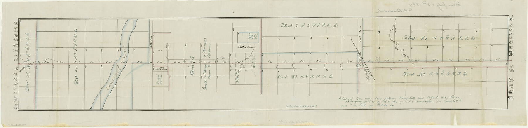
Hemphill County Boundary File 4
Plat of Boundary Line between Hemphill and Roberts Cos. Texas
-
Map/Doc
54639
-
Collection
General Map Collection
-
Counties
Hemphill
-
Subjects
County Boundaries
-
Height x Width
10.0 x 41.1 inches
25.4 x 104.4 cm
Part of: General Map Collection
Tom Green County Sketch File 77

Print $6.00
- Digital $50.00
Tom Green County Sketch File 77
Size 10.0 x 8.5 inches
Map/Doc 38253
Vicinity of San Luis Pass, Galveston Island, Texas

Print $40.00
- Digital $50.00
Vicinity of San Luis Pass, Galveston Island, Texas
1933
Size 37.1 x 57.8 inches
Map/Doc 69943
San Patricio County Boundary File 77

Digital $50.00
San Patricio County Boundary File 77
Map/Doc 81963
Fannin County Sketch File 16

Print $4.00
- Digital $50.00
Fannin County Sketch File 16
1873
Size 8.1 x 10.3 inches
Map/Doc 22469
Flight Mission No. BRA-8M, Frame 75, Jefferson County

Print $20.00
- Digital $50.00
Flight Mission No. BRA-8M, Frame 75, Jefferson County
1953
Size 18.6 x 22.4 inches
Map/Doc 85595
Scurry County Working Sketch 11

Print $20.00
- Digital $50.00
Scurry County Working Sketch 11
1999
Size 26.1 x 24.1 inches
Map/Doc 63840
Cooke County Working Sketch 31

Print $20.00
- Digital $50.00
Cooke County Working Sketch 31
1980
Size 27.0 x 32.2 inches
Map/Doc 68268
San Augustine County Working Sketch 5

Print $20.00
- Digital $50.00
San Augustine County Working Sketch 5
1935
Size 39.0 x 37.4 inches
Map/Doc 63692
Crockett County Working Sketch 97

Print $20.00
- Digital $50.00
Crockett County Working Sketch 97
1979
Size 39.4 x 37.4 inches
Map/Doc 68430
Montgomery County Rolled Sketch 36

Print $20.00
- Digital $50.00
Montgomery County Rolled Sketch 36
1956
Size 25.8 x 23.6 inches
Map/Doc 6812
Cameron County Rolled Sketch 13

Print $40.00
- Digital $50.00
Cameron County Rolled Sketch 13
1952
Size 39.2 x 62.1 inches
Map/Doc 8567
History of Texas from its First Settlement in 1685 to its Annexation to the United States in 1846 (Vol. 1)

History of Texas from its First Settlement in 1685 to its Annexation to the United States in 1846 (Vol. 1)
1856
Map/Doc 97390
You may also like
Yoakum County Rolled Sketch 3(2)

Print $40.00
- Digital $50.00
Yoakum County Rolled Sketch 3(2)
1959
Size 12.4 x 104.3 inches
Map/Doc 76041
Edwards County

Print $20.00
- Digital $50.00
Edwards County
1883
Size 28.2 x 17.9 inches
Map/Doc 3505
Culberson County Rolled Sketch 52

Print $20.00
- Digital $50.00
Culberson County Rolled Sketch 52
Size 19.2 x 25.1 inches
Map/Doc 5674
Karnes County Boundary File 6

Print $16.00
- Digital $50.00
Karnes County Boundary File 6
Size 9.3 x 4.0 inches
Map/Doc 55735
Fort Worth, Tex. "The Queen of the Prairies," County Seat of Tarrant County

Print $20.00
Fort Worth, Tex. "The Queen of the Prairies," County Seat of Tarrant County
1886
Size 26.0 x 33.3 inches
Map/Doc 89082
Roberts County Working Sketch 16

Print $20.00
- Digital $50.00
Roberts County Working Sketch 16
1975
Size 37.1 x 39.8 inches
Map/Doc 63542
Presidio County Rolled Sketch 56

Print $20.00
- Digital $50.00
Presidio County Rolled Sketch 56
1915
Size 21.8 x 17.1 inches
Map/Doc 7349
Presidio County Sketch File 95

Print $22.00
- Digital $50.00
Presidio County Sketch File 95
1958
Size 12.7 x 16.4 inches
Map/Doc 34773
Sterling County Rolled Sketch 21

Print $20.00
- Digital $50.00
Sterling County Rolled Sketch 21
Size 29.6 x 23.8 inches
Map/Doc 7849
[Sketch for Mineral Application 26649-26650 - Sabine River, Harry A. Wolan]
![65565, [Sketch for Mineral Application 26649-26650 - Sabine River, Harry A. Wolan], General Map Collection](https://historictexasmaps.com/wmedia_w700/maps/65565.tif.jpg)
Print $40.00
- Digital $50.00
[Sketch for Mineral Application 26649-26650 - Sabine River, Harry A. Wolan]
Size 36.8 x 71.9 inches
Map/Doc 65565

Bandera County Working Sketch 57

Print $20.00
- Digital $50.00
Bandera County Working Sketch 57
1991
Size 38.5 x 46.8 inches
Map/Doc 67653