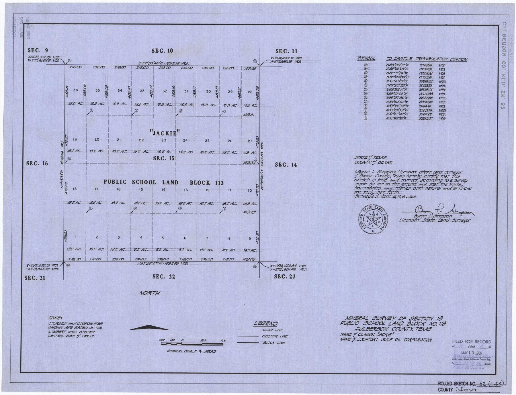
Culberson County Rolled Sketch 52
Mineral survey of section 15, Public School Land Block No. 113, Culberson County, Texas
-
Map/Doc
5674
-
Collection
General Map Collection
-
Object Dates
1966/4/15 (Survey Date)
1966/11/3 (File Date)
-
People and Organizations
Byron L. Simpson (Surveyor/Engineer)
-
Counties
Culberson
-
Subjects
Surveying Rolled Sketch
-
Height x Width
19.2 x 25.1 inches
48.8 x 63.8 cm
-
Medium
linen, manuscript
Part of: General Map Collection
Angelina County Working Sketch 18

Print $20.00
- Digital $50.00
Angelina County Working Sketch 18
1944
Size 26.6 x 28.8 inches
Map/Doc 67099
East Part of Jeff Davis Co.

Print $20.00
- Digital $50.00
East Part of Jeff Davis Co.
1977
Size 46.4 x 35.7 inches
Map/Doc 73194

McCulloch County Sketch File 14

Print $8.00
- Digital $50.00
McCulloch County Sketch File 14
1990
Size 11.2 x 8.7 inches
Map/Doc 31203
Maverick County Sketch File 24

Print $36.00
- Digital $50.00
Maverick County Sketch File 24
1890
Size 9.1 x 8.7 inches
Map/Doc 31145
Clay County Working Sketch 5

Print $20.00
- Digital $50.00
Clay County Working Sketch 5
1923
Size 41.2 x 35.9 inches
Map/Doc 68028
Polk County Sketch File 16

Print $4.00
- Digital $50.00
Polk County Sketch File 16
1861
Size 7.9 x 11.1 inches
Map/Doc 34161
Travis County Rolled Sketch 11

Print $20.00
- Digital $50.00
Travis County Rolled Sketch 11
Size 23.3 x 37.9 inches
Map/Doc 8014
Presidio County Working Sketch 132

Print $20.00
- Digital $50.00
Presidio County Working Sketch 132
1989
Size 36.7 x 29.4 inches
Map/Doc 71810
Waller County Sketch File 3

Print $4.00
- Digital $50.00
Waller County Sketch File 3
Size 13.0 x 8.4 inches
Map/Doc 39598
[10th St and 29th St Groins - Galveston]
![73621, [10th St and 29th St Groins - Galveston], General Map Collection](https://historictexasmaps.com/wmedia_w700/maps/73621-1.tif.jpg)
Print $6.00
- Digital $50.00
[10th St and 29th St Groins - Galveston]
1983
Size 25.6 x 35.2 inches
Map/Doc 73621
Cottle County Working Sketch 8

Print $20.00
- Digital $50.00
Cottle County Working Sketch 8
1917
Size 26.9 x 29.7 inches
Map/Doc 68318
You may also like
Brazoria County Rolled Sketch AH

Print $20.00
- Digital $50.00
Brazoria County Rolled Sketch AH
Size 43.9 x 31.2 inches
Map/Doc 10714
[Sketch showing B. S. & F. Block 9 and vicinity]
![89786, [Sketch showing B. S. & F. Block 9 and vicinity], Twichell Survey Records](https://historictexasmaps.com/wmedia_w700/maps/89786-1.tif.jpg)
Print $20.00
- Digital $50.00
[Sketch showing B. S. & F. Block 9 and vicinity]
Size 39.0 x 47.6 inches
Map/Doc 89786
General Highway Map, Cameron County, Texas

Print $20.00
General Highway Map, Cameron County, Texas
1961
Size 18.3 x 24.7 inches
Map/Doc 79397
Liberty County Working Sketch 28

Print $20.00
- Digital $50.00
Liberty County Working Sketch 28
1942
Size 22.4 x 23.2 inches
Map/Doc 70487
Map of Clemens State Farm, Brazoria County, Texas

Print $20.00
- Digital $50.00
Map of Clemens State Farm, Brazoria County, Texas
1934
Size 31.2 x 36.1 inches
Map/Doc 62984
[Aransas Bay]
![72971, [Aransas Bay], General Map Collection](https://historictexasmaps.com/wmedia_w700/maps/72971.tif.jpg)
Print $20.00
- Digital $50.00
[Aransas Bay]
1846
Size 18.2 x 24.7 inches
Map/Doc 72971
El Paso County Rolled Sketch 2

Print $40.00
- Digital $50.00
El Paso County Rolled Sketch 2
Size 42.8 x 124.4 inches
Map/Doc 76433
Castro County Working Sketch 5

Print $20.00
- Digital $50.00
Castro County Working Sketch 5
1943
Size 11.9 x 18.3 inches
Map/Doc 67900
Montgomery County Sketch File 29

Print $8.00
- Digital $50.00
Montgomery County Sketch File 29
1932
Size 11.2 x 8.6 inches
Map/Doc 31884
Lyons Subdivision

Print $20.00
- Digital $50.00
Lyons Subdivision
1946
Size 17.5 x 16.3 inches
Map/Doc 92429
El Paso County Boundary File 7a

Print $20.00
- Digital $50.00
El Paso County Boundary File 7a
Size 14.2 x 8.3 inches
Map/Doc 53094
Reagan County Rolled Sketch 24

Print $26.00
- Digital $50.00
Reagan County Rolled Sketch 24
Size 44.0 x 39.9 inches
Map/Doc 9819