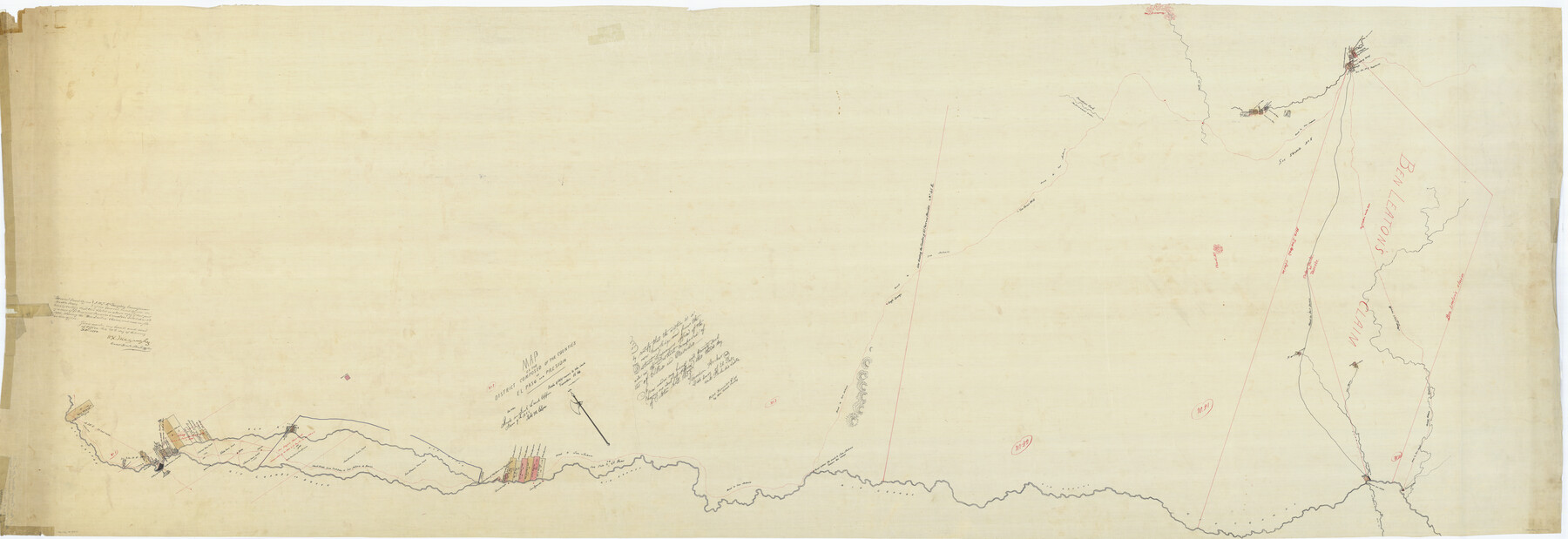
El Paso County Rolled Sketch 2
Map of the District composed of the counties of El Paso and Presidio
-
Map/Doc
76433
-
Collection
General Map Collection
-
Object Dates
1855/11/9 (File Date)
1892/2/15 (Copy/Tracing Date)
-
People and Organizations
Stevenson Archer (Surveyor/Engineer)
W.L. McGaughey (GLO Commissioner)
-
Counties
El Paso Hudspeth Presidio
-
Subjects
Surveying Rolled Sketch
-
Height x Width
42.8 x 124.4 inches
108.7 x 316.0 cm
-
Medium
linen, manuscript
-
Scale
1" = 4000 varas
Part of: General Map Collection
Coleman County Sketch File 46

Print $20.00
- Digital $50.00
Coleman County Sketch File 46
1894
Size 24.0 x 21.8 inches
Map/Doc 11125
Real County Working Sketch 64

Print $20.00
- Digital $50.00
Real County Working Sketch 64
1968
Size 31.4 x 30.0 inches
Map/Doc 71956
Sutton County Working Sketch 28

Print $20.00
- Digital $50.00
Sutton County Working Sketch 28
Size 35.7 x 20.5 inches
Map/Doc 62371
Map of Angelina County

Print $20.00
- Digital $50.00
Map of Angelina County
1862
Size 19.1 x 27.0 inches
Map/Doc 3233
Montgomery County Working Sketch 58

Print $40.00
- Digital $50.00
Montgomery County Working Sketch 58
1962
Size 39.1 x 51.0 inches
Map/Doc 71165
Starr County Rolled Sketch 28

Print $20.00
- Digital $50.00
Starr County Rolled Sketch 28
1941
Size 29.0 x 20.6 inches
Map/Doc 7811
Moore County Working Sketch 7

Print $20.00
- Digital $50.00
Moore County Working Sketch 7
1939
Size 10.8 x 17.8 inches
Map/Doc 71189
Southern Part of Laguna Madre

Print $20.00
- Digital $50.00
Southern Part of Laguna Madre
1936
Size 44.0 x 35.3 inches
Map/Doc 73533
Pecos County Rolled Sketch 85

Print $20.00
- Digital $50.00
Pecos County Rolled Sketch 85
1931
Size 36.7 x 24.4 inches
Map/Doc 7243
![4781, Coke Co[unty], General Map Collection](https://historictexasmaps.com/wmedia_w700/maps/4781.tif.jpg)
Irion County Rolled Sketch 18

Print $20.00
- Digital $50.00
Irion County Rolled Sketch 18
1956
Size 30.5 x 26.3 inches
Map/Doc 6326
Falls County Sketch File 19

Print $4.00
- Digital $50.00
Falls County Sketch File 19
1871
Size 12.8 x 8.4 inches
Map/Doc 22386
You may also like

Flight Mission No. CRK-8P, Frame 102, Refugio County

Print $20.00
- Digital $50.00
Flight Mission No. CRK-8P, Frame 102, Refugio County
1956
Size 18.2 x 22.0 inches
Map/Doc 86963
Brazoria County Rolled Sketch 49

Print $20.00
- Digital $50.00
Brazoria County Rolled Sketch 49
1948
Size 23.7 x 36.3 inches
Map/Doc 5183

Zavala County Working Sketch 23

Print $40.00
- Digital $50.00
Zavala County Working Sketch 23
1980
Size 77.3 x 43.6 inches
Map/Doc 62098
Bexar County Rolled Sketch 16
Print $20.00
- Digital $50.00
Bexar County Rolled Sketch 16
1847
Size 21.1 x 14.8 inches
Map/Doc 5141
Angelina County Working Sketch 22b

Print $20.00
- Digital $50.00
Angelina County Working Sketch 22b
1953
Size 21.5 x 19.6 inches
Map/Doc 67104
Rio Grande, La Puerta Sheet

Print $20.00
- Digital $50.00
Rio Grande, La Puerta Sheet
1931
Size 29.7 x 43.4 inches
Map/Doc 65106
Flight Mission No. DIX-5P, Frame 113, Aransas County

Print $20.00
- Digital $50.00
Flight Mission No. DIX-5P, Frame 113, Aransas County
1956
Size 17.6 x 17.7 inches
Map/Doc 83792
Eastland County Sketch File 21

Print $8.00
- Digital $50.00
Eastland County Sketch File 21
1990
Size 11.3 x 8.8 inches
Map/Doc 21622
Polk County Sketch File 26

Print $12.00
- Digital $50.00
Polk County Sketch File 26
1889
Size 8.5 x 7.1 inches
Map/Doc 34183
Right of Way & Track Map, St. Louis, Brownsville & Mexico Ry. operated by St. Louis, Brownsville & Mexico Ry. Co.

Print $40.00
- Digital $50.00
Right of Way & Track Map, St. Louis, Brownsville & Mexico Ry. operated by St. Louis, Brownsville & Mexico Ry. Co.
1919
Size 25.2 x 57.1 inches
Map/Doc 64613