Falls County Sketch File 19
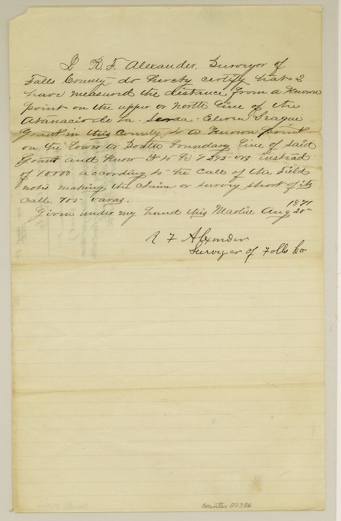
[Surveyor's statement regarding meanders along the riverfront of the de la Serda grant]
-
Map/Doc
22386
-
Collection
General Map Collection
-
Object Dates
1871/8/20 (Creation Date)
-
People and Organizations
R.F. Alexander (Surveyor/Engineer)
-
Counties
Falls
-
Subjects
Surveying Sketch File
-
Height x Width
12.8 x 8.4 inches
32.5 x 21.3 cm
-
Medium
paper, manuscript
Part of: General Map Collection
Edwards County Working Sketch 45

Print $40.00
- Digital $50.00
Edwards County Working Sketch 45
1950
Size 65.4 x 43.4 inches
Map/Doc 68921
Map of Cherokee County

Print $20.00
- Digital $50.00
Map of Cherokee County
1863
Size 25.5 x 17.7 inches
Map/Doc 3387
Hall County Sketch File 6

Print $20.00
- Digital $50.00
Hall County Sketch File 6
1885
Size 28.2 x 37.9 inches
Map/Doc 10473
Cooke County Working Sketch Graphic Index

Print $20.00
- Digital $50.00
Cooke County Working Sketch Graphic Index
1935
Size 44.7 x 38.2 inches
Map/Doc 76504
Coast Chart No. 210 Aransas Pass and Corpus Christi Bay with the coast to latitude 27° 12' Texas

Print $20.00
- Digital $50.00
Coast Chart No. 210 Aransas Pass and Corpus Christi Bay with the coast to latitude 27° 12' Texas
1887
Size 27.2 x 18.2 inches
Map/Doc 72801
San Patricio County Sketch File 35

Print $16.00
- Digital $50.00
San Patricio County Sketch File 35
1917
Size 14.5 x 8.8 inches
Map/Doc 36121
A Traveler's Map of Spain and Portugal

A Traveler's Map of Spain and Portugal
Size 36.1 x 22.9 inches
Map/Doc 95937
Collin County Sketch File 12

Print $40.00
- Digital $50.00
Collin County Sketch File 12
1851
Size 24.3 x 31.3 inches
Map/Doc 11127
Harlem State Farm, East Tract

Print $3.00
- Digital $50.00
Harlem State Farm, East Tract
Size 15.6 x 11.9 inches
Map/Doc 62983
Reeves County Working Sketch 32

Print $40.00
- Digital $50.00
Reeves County Working Sketch 32
1969
Size 58.3 x 37.9 inches
Map/Doc 63475
Flight Mission No. BRE-3P, Frame 80, Nueces County

Print $20.00
- Digital $50.00
Flight Mission No. BRE-3P, Frame 80, Nueces County
1956
Size 18.7 x 22.6 inches
Map/Doc 86821
Live Oak County Working Sketch 17

Print $20.00
- Digital $50.00
Live Oak County Working Sketch 17
1960
Size 29.5 x 26.9 inches
Map/Doc 70602
You may also like
Kerr County Working Sketch 11

Print $20.00
- Digital $50.00
Kerr County Working Sketch 11
1951
Size 30.3 x 29.9 inches
Map/Doc 70042
Kenedy County Aerial Photograph Index Sheet 9

Print $20.00
- Digital $50.00
Kenedy County Aerial Photograph Index Sheet 9
1943
Size 23.6 x 18.5 inches
Map/Doc 83717
Duval County Sketch File 61

Print $6.00
- Digital $50.00
Duval County Sketch File 61
1940
Size 11.4 x 8.9 inches
Map/Doc 21431
Newton County Rolled Sketch JFB

Print $20.00
- Digital $50.00
Newton County Rolled Sketch JFB
1936
Size 16.0 x 38.3 inches
Map/Doc 6858
Pecos County Sketch File 63

Print $94.00
- Digital $50.00
Pecos County Sketch File 63
1919
Size 8.1 x 13.9 inches
Map/Doc 33792
Marion County Sketch File 1a

Print $3.00
- Digital $50.00
Marion County Sketch File 1a
1867
Size 17.4 x 7.7 inches
Map/Doc 30559
[CTRR Co. Block T, Cottle County, Texas]
![10777, [CTRR Co. Block T, Cottle County, Texas], Maddox Collection](https://historictexasmaps.com/wmedia_w700/maps/10777.tif.jpg)
Print $20.00
- Digital $50.00
[CTRR Co. Block T, Cottle County, Texas]
Size 21.5 x 14.0 inches
Map/Doc 10777
Aransas County Rolled Sketch 9

Print $40.00
- Digital $50.00
Aransas County Rolled Sketch 9
1955
Size 85.3 x 41.9 inches
Map/Doc 8409
Map of Denton County

Print $20.00
- Digital $50.00
Map of Denton County
1896
Size 25.6 x 22.0 inches
Map/Doc 11311
Flight Mission No. CLL-1N, Frame 110, Willacy County

Print $20.00
- Digital $50.00
Flight Mission No. CLL-1N, Frame 110, Willacy County
1954
Size 18.5 x 22.1 inches
Map/Doc 87044

Navigation Maps of Gulf Intracoastal Waterway, Port Arthur to Brownsville, Texas

Print $4.00
- Digital $50.00
Navigation Maps of Gulf Intracoastal Waterway, Port Arthur to Brownsville, Texas
1951
Size 16.7 x 21.5 inches
Map/Doc 65418