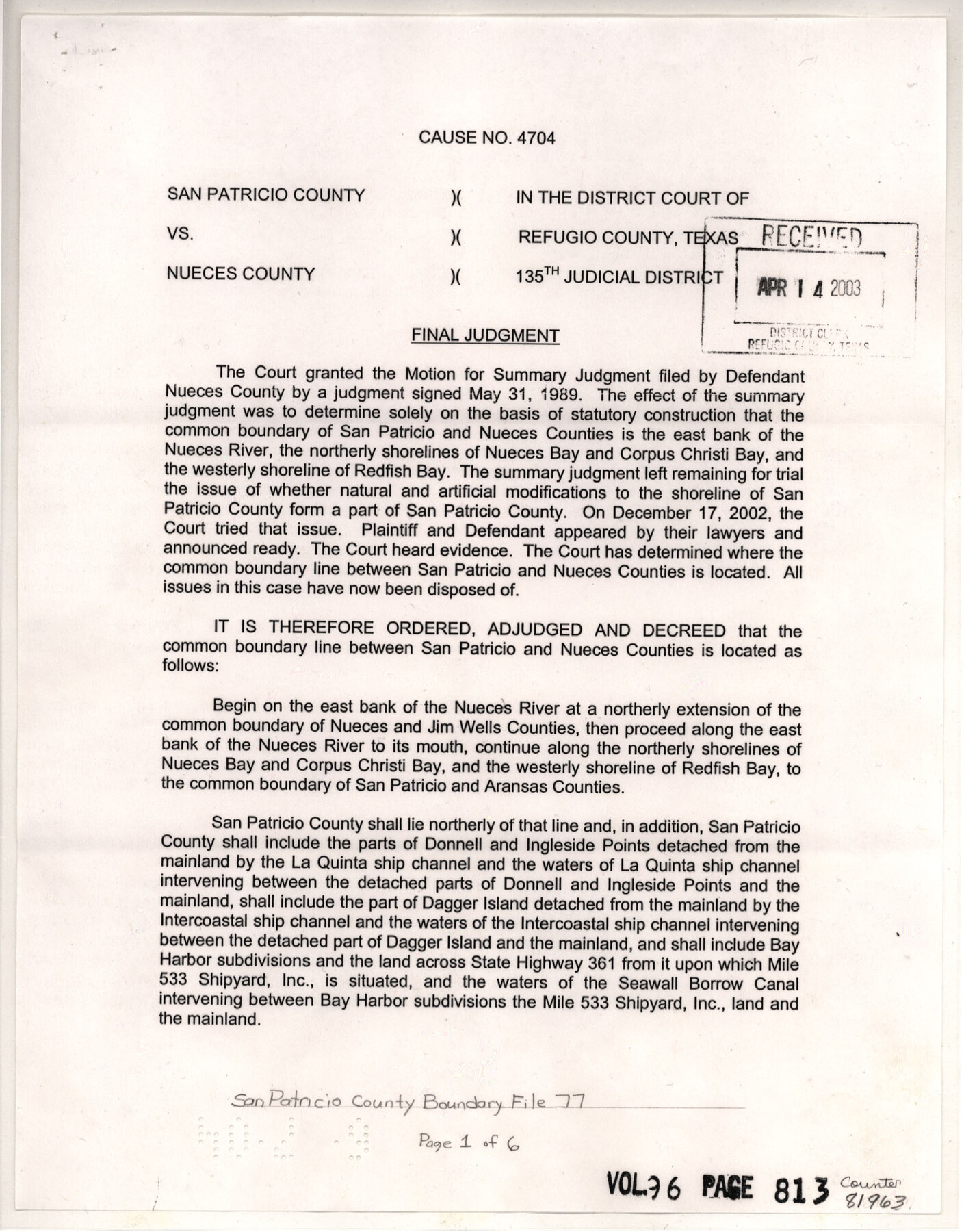
San Patricio County Boundary File 77
[San Patricio vs. Nueces, beginning at the common corner of Nueces and Jim Wells Cos, going clockwise to the common boundary of San Patricio and Aransas Cos., Dist. Court of Refugio County, 135th Judicial District, Cause No. 4704]
-
Map/Doc
81963
-
Collection
General Map Collection
-
Subjects
County Boundaries
Part of: General Map Collection
Controlled Mosaic by Jack Amman Photogrammetric Engineers, Inc - Sheet 51

Print $20.00
- Digital $50.00
Controlled Mosaic by Jack Amman Photogrammetric Engineers, Inc - Sheet 51
1954
Size 20.0 x 24.0 inches
Map/Doc 83510
Burnet County Sketch File 6

Print $8.00
- Digital $50.00
Burnet County Sketch File 6
1854
Size 10.1 x 8.1 inches
Map/Doc 16682
Clay County Sketch File 9

Print $6.00
- Digital $50.00
Clay County Sketch File 9
1860
Size 8.4 x 7.6 inches
Map/Doc 18400
Pecos County Sketch File 1A

Print $20.00
- Digital $50.00
Pecos County Sketch File 1A
1919
Size 34.3 x 23.7 inches
Map/Doc 12155
Foard County Sketch File 31

Print $6.00
- Digital $50.00
Foard County Sketch File 31
1945
Size 14.5 x 9.1 inches
Map/Doc 22861
Val Verde County Working Sketch Graphic Index, Sheet 1 (Sketches 1 to 25)

Print $20.00
- Digital $50.00
Val Verde County Working Sketch Graphic Index, Sheet 1 (Sketches 1 to 25)
1944
Size 40.4 x 36.5 inches
Map/Doc 76724
Schleicher County Sketch File 22

Print $9.00
- Digital $50.00
Schleicher County Sketch File 22
1927
Size 12.8 x 11.7 inches
Map/Doc 36512
Travis County

Print $40.00
- Digital $50.00
Travis County
1936
Size 45.6 x 52.3 inches
Map/Doc 77438

McMullen County Working Sketch 34

Print $20.00
- Digital $50.00
McMullen County Working Sketch 34
1959
Size 25.9 x 26.0 inches
Map/Doc 70735
Starr County Sketch File 30B

Print $12.00
- Digital $50.00
Starr County Sketch File 30B
1935
Size 9.3 x 9.1 inches
Map/Doc 36954
Flight Mission No. DQO-3K, Frame 24, Galveston County

Print $20.00
- Digital $50.00
Flight Mission No. DQO-3K, Frame 24, Galveston County
1952
Size 18.7 x 22.4 inches
Map/Doc 85065
You may also like
Flight Mission No. DQO-8K, Frame 68, Galveston County

Print $20.00
- Digital $50.00
Flight Mission No. DQO-8K, Frame 68, Galveston County
1952
Size 17.3 x 19.5 inches
Map/Doc 85172
Burnet County Working Sketch 25

Print $20.00
- Digital $50.00
Burnet County Working Sketch 25
2000
Size 24.2 x 30.3 inches
Map/Doc 67868
Culberson County Rolled Sketch 40

Print $20.00
- Digital $50.00
Culberson County Rolled Sketch 40
Size 32.1 x 25.0 inches
Map/Doc 8751
Nueces County Rolled Sketch 85

Print $72.00
Nueces County Rolled Sketch 85
1982
Size 18.5 x 24.9 inches
Map/Doc 6971
Hood County Working Sketch 14

Print $20.00
- Digital $50.00
Hood County Working Sketch 14
1980
Size 24.1 x 24.6 inches
Map/Doc 66208
Cameron County Rolled Sketch 20B

Print $20.00
- Digital $50.00
Cameron County Rolled Sketch 20B
Size 24.3 x 12.7 inches
Map/Doc 5473
Donley County Rolled Sketch 5

Print $40.00
- Digital $50.00
Donley County Rolled Sketch 5
1982
Size 56.6 x 32.9 inches
Map/Doc 8801
Flight Mission No. DIX-6P, Frame 198, Aransas County

Print $20.00
- Digital $50.00
Flight Mission No. DIX-6P, Frame 198, Aransas County
1956
Size 19.1 x 22.9 inches
Map/Doc 83860
Duval County Sketch File 53

Print $4.00
- Digital $50.00
Duval County Sketch File 53
1937
Size 11.6 x 7.3 inches
Map/Doc 21416
[Surveys along Trinity River]
![7, [Surveys along Trinity River], General Map Collection](https://historictexasmaps.com/wmedia_w700/maps/7.tif.jpg)
Print $20.00
- Digital $50.00
[Surveys along Trinity River]
1844
Size 21.4 x 12.6 inches
Map/Doc 7
Cochran County, Texas

Print $40.00
- Digital $50.00
Cochran County, Texas
Size 38.1 x 48.3 inches
Map/Doc 89870
Gulf of Mexico

Print $20.00
- Digital $50.00
Gulf of Mexico
1908
Size 18.3 x 27.1 inches
Map/Doc 72656