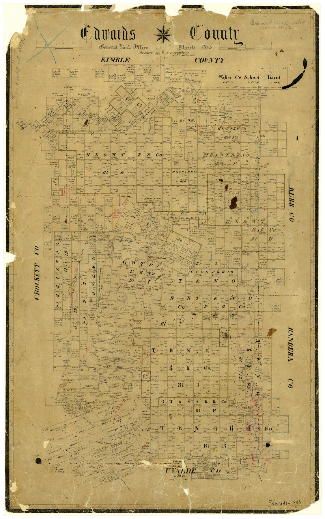
Edwards County
-
Map/Doc
3505
-
Collection
General Map Collection
-
Object Dates
1883 (Creation Date)
-
People and Organizations
Texas General Land Office (Publisher)
Sam. P. Matthews (Draftsman)
-
Counties
Edwards
-
Subjects
County
-
Height x Width
28.2 x 17.9 inches
71.6 x 45.5 cm
-
Features
South Fork of Llano River
Paint Creek
Green Lake
McKinzie [sic] Lake
Head Springs of East Nueces River
Rio Frio
Bull Head Creek
Cedar Prong of Middle Nueces River
Cedar Creek
Leakey
Middle Fork of Nueces River
East Fork of Nueces River
Camp Wood
Nueces River
Barksdale Post Office
Vance
Part of: General Map Collection
Map of Travis County

Print $20.00
- Digital $50.00
Map of Travis County
1861
Size 24.0 x 28.6 inches
Map/Doc 4088
Current Miscellaneous File 35

Print $10.00
- Digital $50.00
Current Miscellaneous File 35
Size 14.2 x 8.7 inches
Map/Doc 73947
Flight Mission No. CGI-1N, Frame 220, Cameron County

Print $20.00
- Digital $50.00
Flight Mission No. CGI-1N, Frame 220, Cameron County
1955
Size 18.5 x 22.1 inches
Map/Doc 84529
Flight Mission No. DCL-5C, Frame 72, Kenedy County

Print $20.00
- Digital $50.00
Flight Mission No. DCL-5C, Frame 72, Kenedy County
1943
Size 18.7 x 22.5 inches
Map/Doc 85855
Houston County Working Sketch 33

Print $40.00
- Digital $50.00
Houston County Working Sketch 33
1987
Size 37.6 x 58.7 inches
Map/Doc 66263
Newton County Working Sketch 19

Print $20.00
- Digital $50.00
Newton County Working Sketch 19
1951
Size 28.7 x 23.4 inches
Map/Doc 71265
Flight Mission No. BRA-16M, Frame 53, Jefferson County

Print $20.00
- Digital $50.00
Flight Mission No. BRA-16M, Frame 53, Jefferson County
1953
Size 18.4 x 22.6 inches
Map/Doc 85670
Map of Portion of the Gulf of Mexico Adjoining Jefferson County Showing Subdivision Thereof for Mineral Development

Print $20.00
- Digital $50.00
Map of Portion of the Gulf of Mexico Adjoining Jefferson County Showing Subdivision Thereof for Mineral Development
1937
Size 20.5 x 39.0 inches
Map/Doc 3020
Hays County Boundary File 42

Print $6.00
- Digital $50.00
Hays County Boundary File 42
Size 9.1 x 3.7 inches
Map/Doc 54609
Dawson County Working Sketch 19

Print $20.00
- Digital $50.00
Dawson County Working Sketch 19
1963
Size 24.8 x 32.4 inches
Map/Doc 68563
Northeast Part Pecos County

Print $20.00
- Digital $50.00
Northeast Part Pecos County
1975
Size 35.8 x 42.3 inches
Map/Doc 73260
Comanche County

Print $20.00
- Digital $50.00
Comanche County
1896
Size 41.7 x 44.8 inches
Map/Doc 4736
You may also like
[Sections 61-63, I. & G. N. Block 1 and sections 33 and 34, Block 194]
![91643, [Sections 61-63, I. & G. N. Block 1 and sections 33 and 34, Block 194], Twichell Survey Records](https://historictexasmaps.com/wmedia_w700/maps/91643-1.tif.jpg)
Print $20.00
- Digital $50.00
[Sections 61-63, I. & G. N. Block 1 and sections 33 and 34, Block 194]
Size 17.3 x 25.4 inches
Map/Doc 91643
Nueces River, Clarkwood Sheet

Print $6.00
- Digital $50.00
Nueces River, Clarkwood Sheet
1942
Size 26.9 x 36.5 inches
Map/Doc 65099
Sutton County Rolled Sketch 41

Print $20.00
- Digital $50.00
Sutton County Rolled Sketch 41
1938
Size 34.5 x 23.3 inches
Map/Doc 7883
No. 2 Chart of Corpus Christi Pass, Texas

Print $20.00
- Digital $50.00
No. 2 Chart of Corpus Christi Pass, Texas
1878
Size 18.3 x 27.3 inches
Map/Doc 73021
Collingsworth County

Print $20.00
- Digital $50.00
Collingsworth County
1880
Size 24.9 x 20.0 inches
Map/Doc 3420
Working Sketch in Hale County

Print $3.00
- Digital $50.00
Working Sketch in Hale County
Size 16.4 x 11.8 inches
Map/Doc 90746
Kaufman County Sketch File 10

Print $4.00
- Digital $50.00
Kaufman County Sketch File 10
1873
Size 10.2 x 8.2 inches
Map/Doc 28643
La Louisiane, Suivant les Nouvelles Observations de Messrs de l'Academie Royale des Sciences

Print $20.00
La Louisiane, Suivant les Nouvelles Observations de Messrs de l'Academie Royale des Sciences
1735
Size 9.1 x 11.9 inches
Map/Doc 95279
Gillespie County Working Sketch 11

Print $20.00
- Digital $50.00
Gillespie County Working Sketch 11
2007
Size 27.8 x 38.0 inches
Map/Doc 87212
Atascosa County Sketch File 3b

Print $8.00
- Digital $50.00
Atascosa County Sketch File 3b
1857
Size 11.4 x 5.8 inches
Map/Doc 13739
Armstrong County Sketch File 9

Print $12.00
- Digital $50.00
Armstrong County Sketch File 9
1904
Size 11.6 x 9.1 inches
Map/Doc 41460
Upshur County Sketch File 5

Print $4.00
- Digital $50.00
Upshur County Sketch File 5
1855
Size 8.3 x 12.9 inches
Map/Doc 38740