Dawson County Sketch File 18
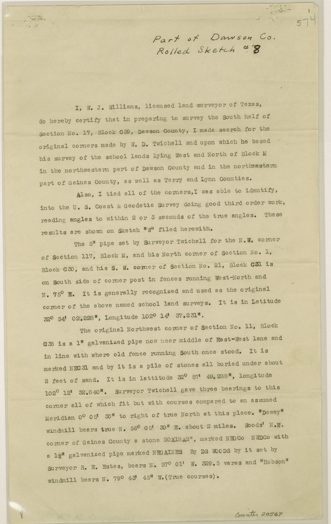
[Report on Blocks C38, C39, C41 and H in northern Dawson and adjacent counties north and west]
-
Map/Doc
20567
-
Collection
General Map Collection
-
Object Dates
1940/10/26 (Creation Date)
1940/11/8 (File Date)
-
People and Organizations
W.J. Williams (Surveyor/Engineer)
W.D. Twichell (Surveyor/Engineer)
-
Counties
Dawson Terry Lynn Gaines
-
Subjects
Surveying Sketch File
-
Height x Width
14.2 x 9.0 inches
36.1 x 22.9 cm
-
Medium
paper, print
-
Comments
See Dawson County Rolled Sketch 8 (8772) for sketch.
-
Features
Dewey Mill
Hobson Mill
Related maps
Dawson County Rolled Sketch 8

Print $40.00
- Digital $50.00
Dawson County Rolled Sketch 8
1940
Size 33.5 x 54.3 inches
Map/Doc 8772
Part of: General Map Collection
Topographical Map of the Rio Grande, Sheet No. 7

Print $20.00
- Digital $50.00
Topographical Map of the Rio Grande, Sheet No. 7
1912
Map/Doc 89531
Haskell County

Print $20.00
- Digital $50.00
Haskell County
1933
Size 44.9 x 37.9 inches
Map/Doc 73175
Flight Mission No. DIX-6P, Frame 116, Aransas County

Print $20.00
- Digital $50.00
Flight Mission No. DIX-6P, Frame 116, Aransas County
1956
Size 19.2 x 23.1 inches
Map/Doc 83822
Travis County Working Sketch 65

Print $20.00
- Digital $50.00
Travis County Working Sketch 65
2003
Size 28.1 x 38.3 inches
Map/Doc 78494
[Map showing the location of the Pecos Valley Railway through H. &. G. N. R.R. Co. Land in Reeves Co., Texas]
![64707, [Map showing the location of the Pecos Valley Railway through H. &. G. N. R.R. Co. Land in Reeves Co., Texas], General Map Collection](https://historictexasmaps.com/wmedia_w700/maps/64707.tif.jpg)
Print $40.00
- Digital $50.00
[Map showing the location of the Pecos Valley Railway through H. &. G. N. R.R. Co. Land in Reeves Co., Texas]
1891
Size 39.1 x 123.6 inches
Map/Doc 64707
Ward County Rolled Sketch 24B

Print $40.00
- Digital $50.00
Ward County Rolled Sketch 24B
1967
Size 24.7 x 56.4 inches
Map/Doc 10115
Flight Mission No. CRK-3P, Frame 126, Refugio County

Print $20.00
- Digital $50.00
Flight Mission No. CRK-3P, Frame 126, Refugio County
1956
Size 18.6 x 22.4 inches
Map/Doc 86914
Harrison County Working Sketch 23

Print $20.00
- Digital $50.00
Harrison County Working Sketch 23
1983
Size 43.2 x 32.2 inches
Map/Doc 66043
Grayson County Working Sketch 13

Print $20.00
- Digital $50.00
Grayson County Working Sketch 13
1952
Size 31.1 x 38.0 inches
Map/Doc 63252
Kimble County Working Sketch 34

Print $20.00
- Digital $50.00
Kimble County Working Sketch 34
1945
Size 34.4 x 26.7 inches
Map/Doc 70102
Coast of Texas and its defences

Print $20.00
- Digital $50.00
Coast of Texas and its defences
1864
Size 27.3 x 18.1 inches
Map/Doc 72683
Martin County Rolled Sketch 10

Print $20.00
- Digital $50.00
Martin County Rolled Sketch 10
1994
Size 18.4 x 24.2 inches
Map/Doc 6670
You may also like
Motley County Sketch File 2 (S)

Print $20.00
- Digital $50.00
Motley County Sketch File 2 (S)
Size 31.1 x 25.1 inches
Map/Doc 42133
Stephens County Sketch File 28

Print $14.00
- Digital $50.00
Stephens County Sketch File 28
1996
Size 14.2 x 8.6 inches
Map/Doc 37104
Uvalde County Working Sketch 30

Print $20.00
- Digital $50.00
Uvalde County Working Sketch 30
1962
Size 27.9 x 40.9 inches
Map/Doc 72100
General Highway Map, Reeves County, Texas

Print $20.00
General Highway Map, Reeves County, Texas
1940
Size 24.8 x 18.2 inches
Map/Doc 79227
Right of Way and Track Map, the Missouri, Kansas and Texas Ry. of Texas - Henrietta Division

Print $20.00
- Digital $50.00
Right of Way and Track Map, the Missouri, Kansas and Texas Ry. of Texas - Henrietta Division
1918
Size 11.8 x 26.8 inches
Map/Doc 64755
Galveston County Sketch File 73I

Print $20.00
- Digital $50.00
Galveston County Sketch File 73I
Size 31.5 x 26.0 inches
Map/Doc 11543
Wichita County Sketch File 26

Print $20.00
- Digital $50.00
Wichita County Sketch File 26
1919
Size 24.9 x 36.6 inches
Map/Doc 12686
Bastrop County Boundary File 1

Print $4.00
- Digital $50.00
Bastrop County Boundary File 1
Size 12.6 x 8.3 inches
Map/Doc 50313
Hansford County Working Sketch 1

Print $40.00
- Digital $50.00
Hansford County Working Sketch 1
1934
Size 43.0 x 54.1 inches
Map/Doc 63373
Anderson County Working Sketch 44

Print $20.00
- Digital $50.00
Anderson County Working Sketch 44
1991
Size 27.7 x 32.3 inches
Map/Doc 67044
The Republic County of Goliad. Boundaries Defined, December 2, 1841

Print $20.00
The Republic County of Goliad. Boundaries Defined, December 2, 1841
2020
Size 17.5 x 21.7 inches
Map/Doc 96151
Angelina County Sketch File 11a

Print $4.00
- Digital $50.00
Angelina County Sketch File 11a
1860
Size 14.4 x 8.3 inches
Map/Doc 12942