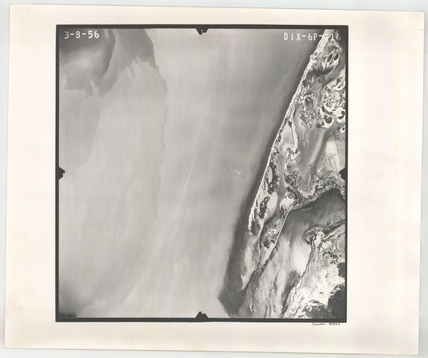
Flight Mission No. DIX-6P, Frame 116, Aransas County
DIX-6P-116
-
Map/Doc
83822
-
Collection
General Map Collection
-
Object Dates
1956/3/8 (Creation Date)
-
People and Organizations
U. S. Department of Agriculture (Publisher)
-
Counties
Aransas
-
Subjects
Aerial Photograph
-
Height x Width
19.2 x 23.1 inches
48.8 x 58.7 cm
-
Comments
Flown by V. L. Beavers and Associates of San Antonio, Texas.
Part of: General Map Collection
Fannin County Sketch File 13

Print $4.00
- Digital $50.00
Fannin County Sketch File 13
Size 8.1 x 7.9 inches
Map/Doc 22462
Galveston Harbor and Channel, Texas Rehabilitation of South Jetty, Comparison of Shorelines and Offshore Contours 1890 to 1960

Print $20.00
- Digital $50.00
Galveston Harbor and Channel, Texas Rehabilitation of South Jetty, Comparison of Shorelines and Offshore Contours 1890 to 1960
1961
Size 31.6 x 41.8 inches
Map/Doc 61827
Map and Profile No. 1 from the Red River to the Rio Grande; from Explorations and surveys made under the direction of the Hon. Jeffeson Davis, Secretary of War

Print $40.00
- Digital $50.00
Map and Profile No. 1 from the Red River to the Rio Grande; from Explorations and surveys made under the direction of the Hon. Jeffeson Davis, Secretary of War
1856
Size 30.5 x 57.0 inches
Map/Doc 4330
Mason County Working Sketch 2

Print $20.00
- Digital $50.00
Mason County Working Sketch 2
1900
Size 31.6 x 36.3 inches
Map/Doc 70838
Controlled Mosaic by Jack Amman Photogrammetric Engineers, Inc - Sheet 28

Print $20.00
- Digital $50.00
Controlled Mosaic by Jack Amman Photogrammetric Engineers, Inc - Sheet 28
1954
Size 21.1 x 24.1 inches
Map/Doc 83480
Armstrong County

Print $20.00
- Digital $50.00
Armstrong County
1904
Size 40.4 x 33.8 inches
Map/Doc 3247
Crockett County Working Sketch 52

Print $20.00
- Digital $50.00
Crockett County Working Sketch 52
1941
Size 26.0 x 33.5 inches
Map/Doc 68385
Aransas County Sketch File 33

Print $34.00
- Digital $50.00
Aransas County Sketch File 33
1919
Size 14.4 x 8.8 inches
Map/Doc 13303
Reeves County

Print $40.00
- Digital $50.00
Reeves County
1903
Size 48.7 x 36.5 inches
Map/Doc 16798
Map of Zavalla County

Print $20.00
- Digital $50.00
Map of Zavalla County
1876
Size 22.5 x 33.2 inches
Map/Doc 4181
Comal County Sketch File 16

Print $4.00
- Digital $50.00
Comal County Sketch File 16
1878
Size 8.4 x 10.7 inches
Map/Doc 19034
Southern Part of Laguna Madre

Print $20.00
- Digital $50.00
Southern Part of Laguna Madre
1949
Size 33.8 x 26.7 inches
Map/Doc 73536
You may also like
Kimble County Working Sketch 41

Print $20.00
- Digital $50.00
Kimble County Working Sketch 41
1948
Size 36.1 x 33.2 inches
Map/Doc 70109
Coryell County Boundary File 3a

Print $50.00
- Digital $50.00
Coryell County Boundary File 3a
Size 13.2 x 8.1 inches
Map/Doc 51914
Kinney County Rolled Sketch 4

Print $20.00
- Digital $50.00
Kinney County Rolled Sketch 4
Size 20.8 x 25.0 inches
Map/Doc 7723
Brazos River Conservation and Reclamation District Official Boundary Line Survey, Parmer County

Print $20.00
- Digital $50.00
Brazos River Conservation and Reclamation District Official Boundary Line Survey, Parmer County
Size 24.5 x 16.9 inches
Map/Doc 91658
Nueces County

Print $20.00
- Digital $50.00
Nueces County
1913
Size 26.9 x 35.9 inches
Map/Doc 95602
Zavala County Rolled Sketch 18

Print $20.00
- Digital $50.00
Zavala County Rolled Sketch 18
Size 39.4 x 27.3 inches
Map/Doc 8322
Travis County Working Sketch 20

Print $20.00
- Digital $50.00
Travis County Working Sketch 20
1945
Size 28.5 x 31.9 inches
Map/Doc 69404
Bell County Sketch File 21

Print $4.00
- Digital $50.00
Bell County Sketch File 21
1871
Size 8.0 x 9.7 inches
Map/Doc 14410
Crosby County Boundary File 3

Print $2.00
- Digital $50.00
Crosby County Boundary File 3
Size 11.2 x 8.7 inches
Map/Doc 52002
Ward County Rolled Sketch 12A

Print $20.00
- Digital $50.00
Ward County Rolled Sketch 12A
Size 34.7 x 46.5 inches
Map/Doc 10108
Ward County Working Sketch 51

Print $40.00
- Digital $50.00
Ward County Working Sketch 51
1980
Size 34.4 x 52.1 inches
Map/Doc 72357
Kenedy County Aerial Photograph Index Sheet 6

Print $20.00
- Digital $50.00
Kenedy County Aerial Photograph Index Sheet 6
1943
Size 23.4 x 18.4 inches
Map/Doc 83716