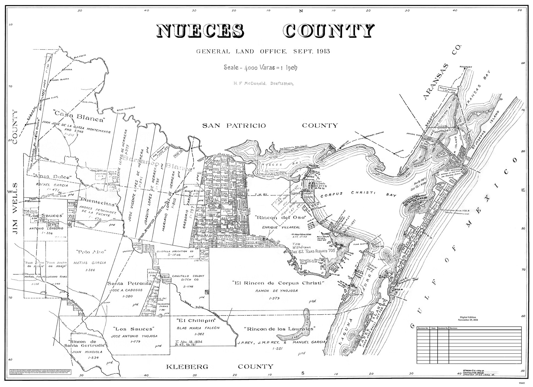
Nueces County
General Land Office Official County Map
-
Map/Doc
95602
-
Collection
General Map Collection
-
Object Dates
9/1913 (Creation Date)
8/31/2019 (Revision Date)
11/29/2024 (Revision Date)
-
People and Organizations
Kat Bird (Draftsman)
Cheyenne Betancourt (Draftsman)
H.F. McDonald (Draftsman)
-
Counties
Nueces
-
Subjects
County OCM
-
Height x Width
26.9 x 35.9 inches
68.3 x 91.2 cm
-
Medium
digital image
-
Scale
1" = 4000 varas
Part of: General Map Collection
Aransas County Working Sketch 4

Print $20.00
- Digital $50.00
Aransas County Working Sketch 4
1928
Size 37.4 x 31.8 inches
Map/Doc 67171
Map of the Surveyed Part of Young District

Print $40.00
- Digital $50.00
Map of the Surveyed Part of Young District
1860
Size 56.3 x 27.3 inches
Map/Doc 87374
Henderson County Working Sketch 2

Print $20.00
- Digital $50.00
Henderson County Working Sketch 2
Size 29.1 x 30.0 inches
Map/Doc 66135
Menard County Sketch File 12

Print $12.00
- Digital $50.00
Menard County Sketch File 12
1892
Size 11.1 x 8.2 inches
Map/Doc 31500
[Capitol Lands in Dallam, Hartley, Oldham, Deaf Smith, Parmer, Bailey, Lamb, Cochran, Castro, and Hockley Counties]
![60295, [Capitol Lands in Dallam, Hartley, Oldham, Deaf Smith, Parmer, Bailey, Lamb, Cochran, Castro, and Hockley Counties], General Map Collection](https://historictexasmaps.com/wmedia_w700/maps/60295.tif.jpg)
Print $40.00
- Digital $50.00
[Capitol Lands in Dallam, Hartley, Oldham, Deaf Smith, Parmer, Bailey, Lamb, Cochran, Castro, and Hockley Counties]
Size 55.4 x 22.0 inches
Map/Doc 60295
El Paso County Sketch File 36

Print $2.00
- Digital $50.00
El Paso County Sketch File 36
1984
Size 11.6 x 9.0 inches
Map/Doc 24123
Erath County Sketch File 28

Print $40.00
- Digital $50.00
Erath County Sketch File 28
1895
Size 16.5 x 12.0 inches
Map/Doc 22309
Wise County Sketch File 13

Print $4.00
- Digital $50.00
Wise County Sketch File 13
Size 9.0 x 15.2 inches
Map/Doc 40546
Oldham County Rolled Sketch 8

Print $20.00
- Digital $50.00
Oldham County Rolled Sketch 8
1931
Size 39.2 x 29.0 inches
Map/Doc 7174
Val Verde County Rolled Sketch 49

Print $20.00
- Digital $50.00
Val Verde County Rolled Sketch 49
Size 26.9 x 34.3 inches
Map/Doc 8120
Liberty County Working Sketch 18

Print $20.00
- Digital $50.00
Liberty County Working Sketch 18
1939
Size 20.5 x 20.4 inches
Map/Doc 70477
Gonzales County Sketch File 4a

Print $4.00
- Digital $50.00
Gonzales County Sketch File 4a
1861
Size 8.0 x 6.7 inches
Map/Doc 24375
You may also like
Block 36, Township 3 North

Print $20.00
- Digital $50.00
Block 36, Township 3 North
Size 12.0 x 15.9 inches
Map/Doc 91289
Flight Mission No. BRA-7M, Frame 15, Jefferson County

Print $20.00
- Digital $50.00
Flight Mission No. BRA-7M, Frame 15, Jefferson County
1953
Size 18.6 x 22.3 inches
Map/Doc 85466
Liberty County Working Sketch 83

Print $40.00
- Digital $50.00
Liberty County Working Sketch 83
1981
Size 68.4 x 37.8 inches
Map/Doc 70543
Tarrant County Boundary File 2

Print $6.00
- Digital $50.00
Tarrant County Boundary File 2
Size 14.4 x 9.0 inches
Map/Doc 59111
General Highway Map, Presidio County, Texas

Print $20.00
General Highway Map, Presidio County, Texas
1940
Size 24.6 x 18.3 inches
Map/Doc 79222
[Part of Block K11, Leagues 346, 357 1/2, 367]
![90530, [Part of Block K11, Leagues 346, 357 1/2, 367], Twichell Survey Records](https://historictexasmaps.com/wmedia_w700/maps/90530-1.tif.jpg)
Print $2.00
- Digital $50.00
[Part of Block K11, Leagues 346, 357 1/2, 367]
Size 7.3 x 11.6 inches
Map/Doc 90530
Brewster County Sketch File S-27

Print $10.00
- Digital $50.00
Brewster County Sketch File S-27
1966
Size 11.4 x 8.7 inches
Map/Doc 15841
Orange County Working Sketch 16

Print $20.00
- Digital $50.00
Orange County Working Sketch 16
1929
Size 25.0 x 24.2 inches
Map/Doc 71348
Parker County Rolled Sketch 1

Print $20.00
- Digital $50.00
Parker County Rolled Sketch 1
1878
Size 19.8 x 24.6 inches
Map/Doc 7202
Flight Mission No. BRE-2P, Frame 54, Nueces County

Print $20.00
- Digital $50.00
Flight Mission No. BRE-2P, Frame 54, Nueces County
1956
Size 18.5 x 22.4 inches
Map/Doc 86756
Polk County Sketch File 6

Print $4.00
- Digital $50.00
Polk County Sketch File 6
Size 7.1 x 9.4 inches
Map/Doc 34129
Coleman County Working Sketch 12

Print $20.00
- Digital $50.00
Coleman County Working Sketch 12
1951
Size 25.7 x 26.2 inches
Map/Doc 68078