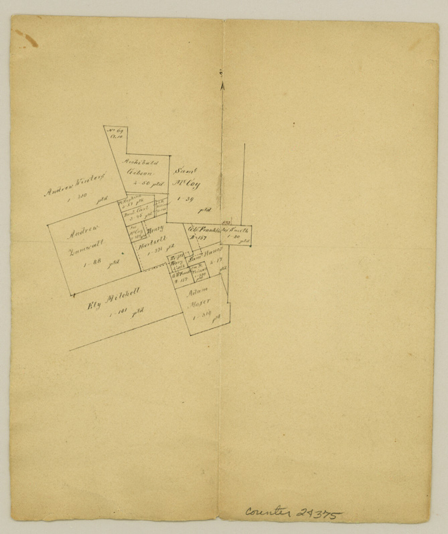
Gonzales County Sketch File 4a
Surveys 3 miles northeast of Gonzales
-
Map/Doc
24375
-
Collection
General Map Collection
-
Object Dates
1861/10/31 (Creation Date)
-
Counties
Gonzales
-
Subjects
Surveying Sketch File
-
Height x Width
8.0 x 6.7 inches
20.3 x 17.0 cm
-
Medium
paper, manuscript
Part of: General Map Collection
Stonewall County Sketch File 4

Print $20.00
- Digital $50.00
Stonewall County Sketch File 4
Size 18.2 x 25.7 inches
Map/Doc 12363
Chambers County Rolled Sketch 29

Print $20.00
- Digital $50.00
Chambers County Rolled Sketch 29
1951
Size 24.2 x 44.4 inches
Map/Doc 5429
Surveys made on the San Miguel. March 1847

Print $2.00
- Digital $50.00
Surveys made on the San Miguel. March 1847
1847
Size 10.4 x 8.4 inches
Map/Doc 223
Brooks County Working Sketch Graphic Index

Print $20.00
- Digital $50.00
Brooks County Working Sketch Graphic Index
1955
Size 41.3 x 33.6 inches
Map/Doc 76479
Brewster County Working Sketch 71a

Print $40.00
- Digital $50.00
Brewster County Working Sketch 71a
1962
Size 43.5 x 56.0 inches
Map/Doc 67869
Nueces County Sketch File 67

Print $4.00
- Digital $50.00
Nueces County Sketch File 67
Size 11.1 x 8.7 inches
Map/Doc 32998
Collin County Sketch File 4

Print $4.00
- Digital $50.00
Collin County Sketch File 4
1856
Size 10.0 x 8.0 inches
Map/Doc 18862
Duval County Sketch File 84

Print $6.00
- Digital $50.00
Duval County Sketch File 84
1945
Size 14.4 x 8.9 inches
Map/Doc 21531
Foard County Sketch File 35

Print $20.00
- Digital $50.00
Foard County Sketch File 35
Size 26.4 x 25.7 inches
Map/Doc 11496

Harris County Sketch File 59a

Print $20.00
- Digital $50.00
Harris County Sketch File 59a
Size 25.1 x 40.1 inches
Map/Doc 10479
Jackson County

Print $20.00
- Digital $50.00
Jackson County
1920
Size 46.9 x 40.1 inches
Map/Doc 95541
You may also like
Blanco County Sketch File 11

Print $4.00
- Digital $50.00
Blanco County Sketch File 11
Size 4.0 x 7.6 inches
Map/Doc 14590
Runnels County Sketch File 6

Print $5.00
Runnels County Sketch File 6
1872
Size 9.9 x 15.9 inches
Map/Doc 35440
Gaines County Working Sketch 29

Print $20.00
- Digital $50.00
Gaines County Working Sketch 29
1984
Size 32.3 x 42.9 inches
Map/Doc 69329

Kinney County Rolled Sketch 18

Print $20.00
- Digital $50.00
Kinney County Rolled Sketch 18
1975
Size 22.4 x 28.6 inches
Map/Doc 6545
Ector County Sketch File 1

Print $20.00
- Digital $50.00
Ector County Sketch File 1
1931
Size 17.1 x 18.0 inches
Map/Doc 11415
[I. & G. N. Block 1, sections 57-70]
![91668, [I. & G. N. Block 1, sections 57-70], Twichell Survey Records](https://historictexasmaps.com/wmedia_w700/maps/91668-1.tif.jpg)
Print $20.00
- Digital $50.00
[I. & G. N. Block 1, sections 57-70]
Size 28.8 x 22.1 inches
Map/Doc 91668
Flight Mission No. DQN-2K, Frame 140, Calhoun County

Print $20.00
- Digital $50.00
Flight Mission No. DQN-2K, Frame 140, Calhoun County
1953
Size 17.2 x 15.9 inches
Map/Doc 84309
[Map Showing Parmer, Castro, Bailey, Lamb, Cochran & Hockley Counties, Texas]
![1762, [Map Showing Parmer, Castro, Bailey, Lamb, Cochran & Hockley Counties, Texas], General Map Collection](https://historictexasmaps.com/wmedia_w700/maps/1762.tif.jpg)
Print $40.00
- Digital $50.00
[Map Showing Parmer, Castro, Bailey, Lamb, Cochran & Hockley Counties, Texas]
1910
Size 55.3 x 40.1 inches
Map/Doc 1762
Flight Mission No. BRE-2P, Frame 94, Nueces County

Print $20.00
- Digital $50.00
Flight Mission No. BRE-2P, Frame 94, Nueces County
1956
Size 18.6 x 22.3 inches
Map/Doc 86779
Jasper County Sketch File 35

Print $6.00
- Digital $50.00
Jasper County Sketch File 35
Size 17.0 x 10.7 inches
Map/Doc 27870
Aransas County Working Sketch 15

Print $20.00
- Digital $50.00
Aransas County Working Sketch 15
1956
Size 22.2 x 19.0 inches
Map/Doc 67182