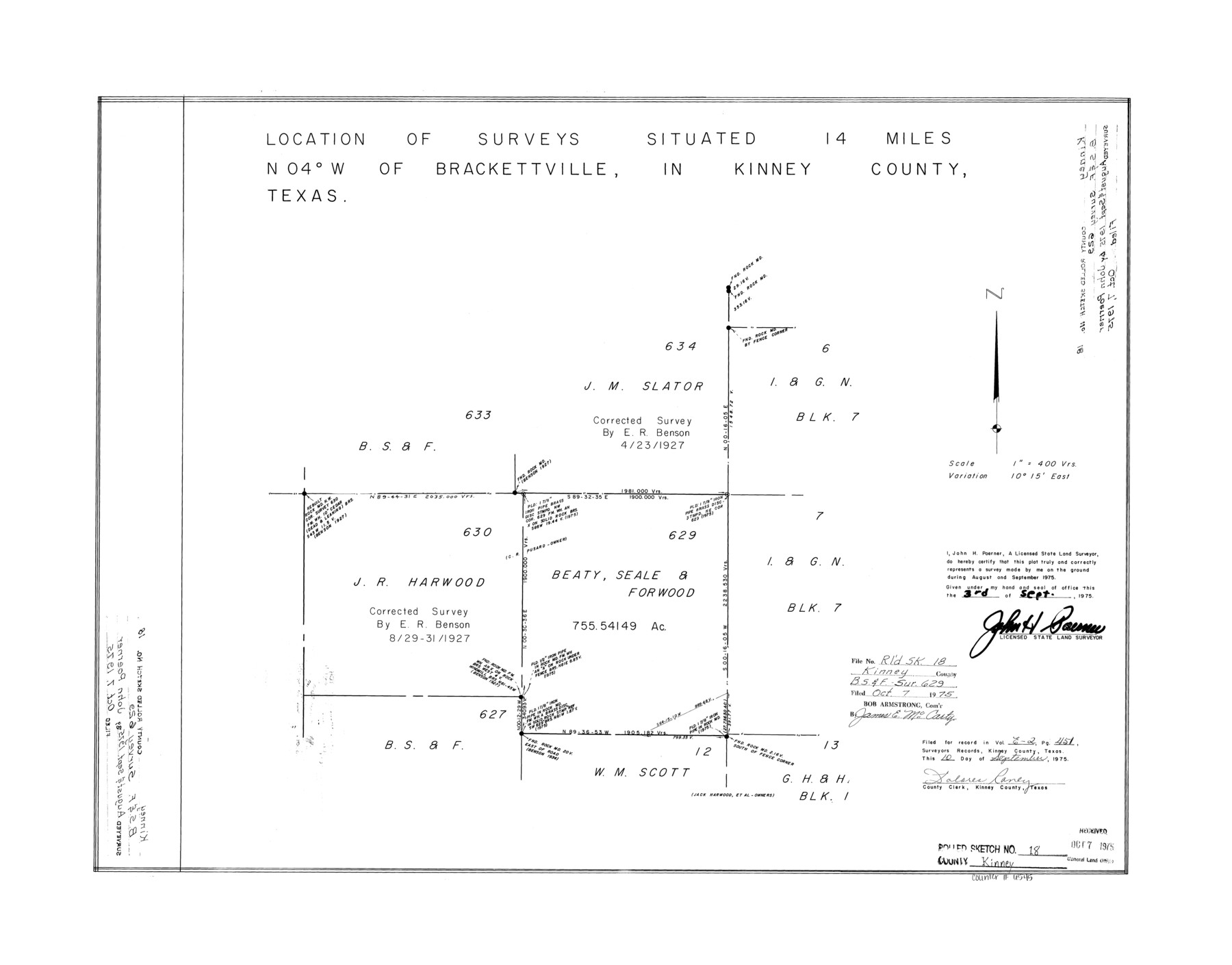
Kinney County Rolled Sketch 18
Location of surveys 629 and 630 north of Brackettville
-
Map/Doc
6545
-
Collection
General Map Collection
-
Object Dates
1975/9/3 (Creation Date)
1975/10/7 (File Date)
-
People and Organizations
John H. Poerner (Surveyor/Engineer)
-
Counties
Kinney
-
Subjects
Surveying Rolled Sketch
-
Height x Width
22.4 x 28.6 inches
56.9 x 72.6 cm
-
Scale
1" = 400 varas
Part of: General Map Collection
Kinney County Rolled Sketch 10

Print $20.00
- Digital $50.00
Kinney County Rolled Sketch 10
1942
Size 22.9 x 20.4 inches
Map/Doc 6539
Robertson Co.

Print $40.00
- Digital $50.00
Robertson Co.
1945
Size 49.5 x 40.3 inches
Map/Doc 95627
Wichita County Rolled Sketch 9

Print $20.00
- Digital $50.00
Wichita County Rolled Sketch 9
1917
Size 28.0 x 27.7 inches
Map/Doc 8246
Atascosa County Working Sketch 33

Print $20.00
- Digital $50.00
Atascosa County Working Sketch 33
1982
Size 16.7 x 13.6 inches
Map/Doc 67229
Denton County Boundary File 4 and 4a and 4b and 4c

Print $14.00
- Digital $50.00
Denton County Boundary File 4 and 4a and 4b and 4c
Size 11.2 x 8.5 inches
Map/Doc 52441
Midland County Working Sketch 3

Print $20.00
- Digital $50.00
Midland County Working Sketch 3
Size 19.5 x 35.2 inches
Map/Doc 70983
Brewster County Rolled Sketch 114

Print $20.00
- Digital $50.00
Brewster County Rolled Sketch 114
1964
Size 11.7 x 18.3 inches
Map/Doc 5276
Morris County Rolled Sketch 2A

Print $20.00
- Digital $50.00
Morris County Rolled Sketch 2A
Size 24.5 x 19.4 inches
Map/Doc 10248
Gaines County Working Sketch 33

Print $40.00
- Digital $50.00
Gaines County Working Sketch 33
1990
Size 50.3 x 36.0 inches
Map/Doc 69333
Cameron County Rolled Sketch 26

Print $20.00
- Digital $50.00
Cameron County Rolled Sketch 26
1960
Size 18.0 x 24.4 inches
Map/Doc 5391

Pecos County Sketch File 106a

Print $4.00
- Digital $50.00
Pecos County Sketch File 106a
1968
Size 11.3 x 8.5 inches
Map/Doc 34033
You may also like
Right-of-way & Track Map Dawson Railway Operated by the El Paso & Southwestern Company Station 360+75.4 to Station 149+55.4

Print $40.00
- Digital $50.00
Right-of-way & Track Map Dawson Railway Operated by the El Paso & Southwestern Company Station 360+75.4 to Station 149+55.4
1910
Size 56.8 x 24.7 inches
Map/Doc 89660
Pecos County Rolled Sketch 165

Print $20.00
- Digital $50.00
Pecos County Rolled Sketch 165
1966
Size 23.4 x 19.6 inches
Map/Doc 7290
Runnels County Rolled Sketch 55

Print $20.00
- Digital $50.00
Runnels County Rolled Sketch 55
2012
Size 20.9 x 18.7 inches
Map/Doc 93386
[SE/4 of NW/4 of King Co.]
![89925, [SE/4 of NW/4 of King Co.], Twichell Survey Records](https://historictexasmaps.com/wmedia_w700/maps/89925-1.tif.jpg)
Print $40.00
- Digital $50.00
[SE/4 of NW/4 of King Co.]
Size 43.7 x 55.5 inches
Map/Doc 89925
Colorado River, Glen Flora Sheet

Print $6.00
- Digital $50.00
Colorado River, Glen Flora Sheet
1941
Size 24.5 x 32.6 inches
Map/Doc 65310
The Republic County of Red River. January 28, 1841

Print $20.00
The Republic County of Red River. January 28, 1841
2020
Size 21.0 x 21.7 inches
Map/Doc 96253

[Sketch for Mineral Application 1112 - Colorado River, H. E. Chambers]
![65637, [Sketch for Mineral Application 1112 - Colorado River, H. E. Chambers], General Map Collection](https://historictexasmaps.com/wmedia_w700/maps/65637.tif.jpg)
Print $20.00
- Digital $50.00
[Sketch for Mineral Application 1112 - Colorado River, H. E. Chambers]
1918
Size 5.5 x 8.5 inches
Map/Doc 65637
Crockett County Rolled Sketch 88H

Print $40.00
- Digital $50.00
Crockett County Rolled Sketch 88H
1973
Size 42.6 x 57.3 inches
Map/Doc 8733
General Highway Map, Brazos County, Texas

Print $20.00
General Highway Map, Brazos County, Texas
1961
Size 24.9 x 18.3 inches
Map/Doc 79384
Foard County Rolled Sketch 15A

Print $20.00
- Digital $50.00
Foard County Rolled Sketch 15A
1889
Size 37.5 x 36.1 inches
Map/Doc 8339
Flight Mission No. CUG-2P, Frame 82, Kleberg County

Print $20.00
- Digital $50.00
Flight Mission No. CUG-2P, Frame 82, Kleberg County
1956
Size 18.5 x 22.3 inches
Map/Doc 86214