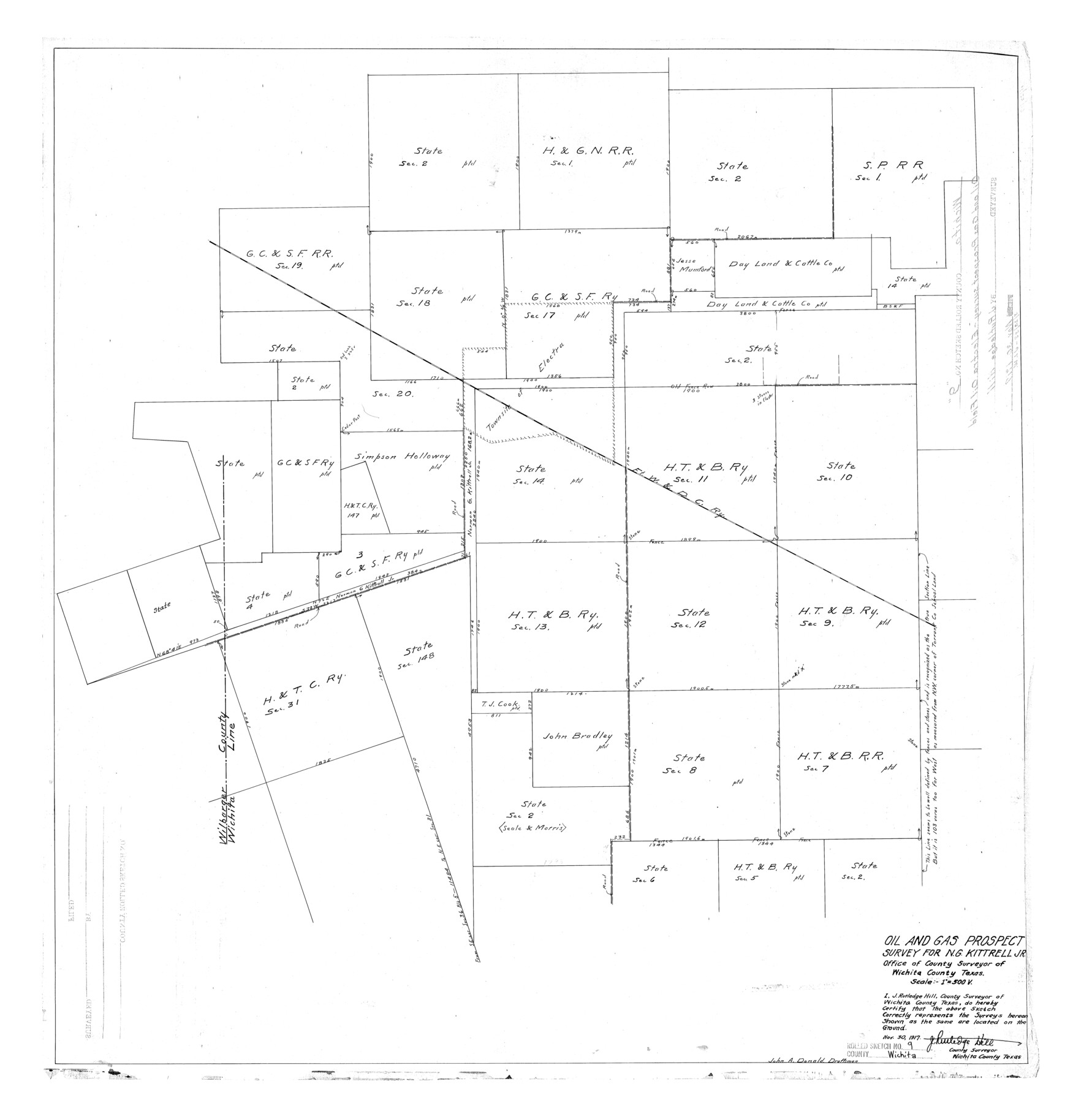
Wichita County Rolled Sketch 9
Oil and gas prospect survey for N.G. Kittrell, Jr.
-
Map/Doc
8246
-
Collection
General Map Collection
-
Object Dates
1917/11/30 (Creation Date)
-
People and Organizations
J. Rutledge Hill (Surveyor/Engineer)
John A. Donald (Draftsman)
-
Counties
Wichita Wilbarger
-
Subjects
Surveying Rolled Sketch
-
Height x Width
28.0 x 27.7 inches
71.1 x 70.4 cm
-
Scale
1" = 500 varas
Part of: General Map Collection
[T. & G. Ry. Main Line, Texas, Right of Way Map, Center to Gary]
![64571, [T. & G. Ry. Main Line, Texas, Right of Way Map, Center to Gary], General Map Collection](https://historictexasmaps.com/wmedia_w700/maps/64571-1.tif.jpg)
Print $40.00
- Digital $50.00
[T. & G. Ry. Main Line, Texas, Right of Way Map, Center to Gary]
1917
Size 31.9 x 121.1 inches
Map/Doc 64571
Fractional Township No. 9 South Range No. 1 East of the Indian Meridian, Indian Territory

Print $20.00
- Digital $50.00
Fractional Township No. 9 South Range No. 1 East of the Indian Meridian, Indian Territory
1898
Size 19.2 x 24.4 inches
Map/Doc 75201
Real County Working Sketch 84

Print $20.00
- Digital $50.00
Real County Working Sketch 84
1986
Size 25.0 x 40.7 inches
Map/Doc 71976
San Augustine Co.

Print $20.00
- Digital $50.00
San Augustine Co.
1949
Size 47.9 x 31.2 inches
Map/Doc 73281
El Paso County Working Sketch 23

Print $20.00
- Digital $50.00
El Paso County Working Sketch 23
1961
Size 22.3 x 28.8 inches
Map/Doc 69045
Matagorda County NRC Article 33.136 Sketch 9

Print $28.00
- Digital $50.00
Matagorda County NRC Article 33.136 Sketch 9
2011
Size 24.0 x 36.0 inches
Map/Doc 94811
[Surveys near Lake Soda made under G.W. Smyth, Commissioner]
![73, [Surveys near Lake Soda made under G.W. Smyth, Commissioner], General Map Collection](https://historictexasmaps.com/wmedia_w700/maps/73.tif.jpg)
Print $20.00
- Digital $50.00
[Surveys near Lake Soda made under G.W. Smyth, Commissioner]
1835
Size 16.0 x 19.3 inches
Map/Doc 73
Coleman County Sketch File 30

Print $8.00
- Digital $50.00
Coleman County Sketch File 30
1875
Size 10.0 x 8.0 inches
Map/Doc 18720
Lee County Working Sketch 16

Print $20.00
- Digital $50.00
Lee County Working Sketch 16
1982
Size 20.5 x 13.5 inches
Map/Doc 70395
Kendall County Boundary File 3a

Print $8.00
- Digital $50.00
Kendall County Boundary File 3a
Size 11.2 x 8.9 inches
Map/Doc 55765
Map of La Salle County

Print $20.00
- Digital $50.00
Map of La Salle County
1879
Size 26.2 x 25.3 inches
Map/Doc 3799
Limestone County Sketch File 10

Print $4.00
- Digital $50.00
Limestone County Sketch File 10
Size 8.4 x 9.4 inches
Map/Doc 30171
You may also like
Flight Mission No. BRE-1P, Frame 79, Nueces County

Print $20.00
- Digital $50.00
Flight Mission No. BRE-1P, Frame 79, Nueces County
1956
Size 18.4 x 22.2 inches
Map/Doc 86661
[Topographical Map]
![92543, [Topographical Map], Twichell Survey Records](https://historictexasmaps.com/wmedia_w700/maps/92543-1.tif.jpg)
Print $20.00
- Digital $50.00
[Topographical Map]
Size 31.2 x 37.5 inches
Map/Doc 92543
Brewster County Sketch File N-15

Print $40.00
- Digital $50.00
Brewster County Sketch File N-15
Size 16.7 x 12.8 inches
Map/Doc 15641
Strip Map of Texas-Oklahoma Boundary from Denison East to the Oklahoma-Arkansas State Line

Print $40.00
- Digital $50.00
Strip Map of Texas-Oklahoma Boundary from Denison East to the Oklahoma-Arkansas State Line
1933
Size 38.7 x 116.3 inches
Map/Doc 75926
Map of the European Settlements in Mexico or New Spain and the West Indies

Print $20.00
- Digital $50.00
Map of the European Settlements in Mexico or New Spain and the West Indies
1783
Size 14.1 x 21.1 inches
Map/Doc 93643
Uvalde County Working Sketch 67

Print $20.00
- Digital $50.00
Uvalde County Working Sketch 67
2016
Size 24.4 x 36.6 inches
Map/Doc 94082
Henderson County Sketch File 22

Print $14.00
- Digital $50.00
Henderson County Sketch File 22
1942
Size 14.2 x 8.9 inches
Map/Doc 26365
Brewster County Rolled Sketch 50

Print $20.00
- Digital $50.00
Brewster County Rolled Sketch 50
1932
Size 21.0 x 26.6 inches
Map/Doc 5226
Map of the H.J. Dorrah survey 16 enlarged from the General Land Office map of the west part of Travis County, Texas

Print $2.00
- Digital $50.00
Map of the H.J. Dorrah survey 16 enlarged from the General Land Office map of the west part of Travis County, Texas
1920
Size 11.1 x 8.6 inches
Map/Doc 612
Limestone County Sketch File 15

Print $8.00
- Digital $50.00
Limestone County Sketch File 15
1883
Size 12.7 x 8.0 inches
Map/Doc 30181
Winkler County Rolled Sketch 15

Print $20.00
- Digital $50.00
Winkler County Rolled Sketch 15
1968
Size 25.1 x 37.8 inches
Map/Doc 10305
[Surveys in Austin's Colony along the San Bernardo River from the mouth of Peach Creek]
![209, [Surveys in Austin's Colony along the San Bernardo River from the mouth of Peach Creek], General Map Collection](https://historictexasmaps.com/wmedia_w700/maps/209.tif.jpg)
Print $20.00
- Digital $50.00
[Surveys in Austin's Colony along the San Bernardo River from the mouth of Peach Creek]
1821
Size 23.4 x 10.6 inches
Map/Doc 209