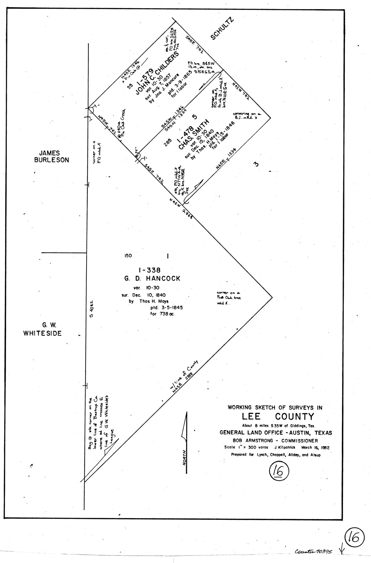
Lee County Working Sketch 16
-
Map/Doc
70395
-
Collection
General Map Collection
-
Object Dates
3/16/1982 (Creation Date)
-
People and Organizations
Joan Kilpatrick (Draftsman)
-
Counties
Lee
-
Subjects
Surveying Working Sketch
-
Height x Width
20.5 x 13.5 inches
52.1 x 34.3 cm
-
Scale
1" = 300 varas
Part of: General Map Collection
Lynn County Sketch File 17

Print $20.00
- Digital $50.00
Lynn County Sketch File 17
Size 13.2 x 20.9 inches
Map/Doc 12020

Terrell County Working Sketch 6

Print $20.00
- Digital $50.00
Terrell County Working Sketch 6
1914
Size 15.7 x 21.9 inches
Map/Doc 62155
Hamilton County Working Sketch 27

Print $20.00
- Digital $50.00
Hamilton County Working Sketch 27
1975
Size 43.4 x 34.3 inches
Map/Doc 63365
Grayson County Working Sketch 5

Print $20.00
- Digital $50.00
Grayson County Working Sketch 5
1939
Size 28.4 x 40.6 inches
Map/Doc 63244
Map of Freestone County

Print $20.00
- Digital $50.00
Map of Freestone County
1858
Size 22.3 x 24.1 inches
Map/Doc 3564
Pecos County Working Sketch 89

Print $20.00
- Digital $50.00
Pecos County Working Sketch 89
1964
Size 46.5 x 34.2 inches
Map/Doc 78216
Flight Mission No. CGI-3N, Frame 131, Cameron County

Print $20.00
- Digital $50.00
Flight Mission No. CGI-3N, Frame 131, Cameron County
1954
Size 18.7 x 22.3 inches
Map/Doc 84604
Lynn County Boundary File 11

Print $44.00
- Digital $50.00
Lynn County Boundary File 11
Size 14.1 x 8.7 inches
Map/Doc 56745
Map of Asia engraved to illustrate Mitchell's school and family geography (Inset: Map of Palestine or the Holy Land)

Print $20.00
- Digital $50.00
Map of Asia engraved to illustrate Mitchell's school and family geography (Inset: Map of Palestine or the Holy Land)
1839
Size 9.5 x 11.8 inches
Map/Doc 93506
San Augustine County Sketch File 8

Print $4.00
San Augustine County Sketch File 8
1858
Size 6.2 x 7.8 inches
Map/Doc 35648
Brewster County Rolled Sketch 114

Print $20.00
- Digital $50.00
Brewster County Rolled Sketch 114
1964
Size 11.4 x 17.7 inches
Map/Doc 5284
You may also like
Flight Mission No. DCL-7C, Frame 122, Kenedy County

Print $20.00
- Digital $50.00
Flight Mission No. DCL-7C, Frame 122, Kenedy County
1943
Size 18.6 x 22.4 inches
Map/Doc 86087
Reagan County Rolled Sketch 21A

Print $20.00
- Digital $50.00
Reagan County Rolled Sketch 21A
1950
Size 34.8 x 43.4 inches
Map/Doc 9816
General Highway Map, Terry County, Texas

Print $20.00
General Highway Map, Terry County, Texas
1940
Size 18.5 x 24.9 inches
Map/Doc 79257
Bandera County Sketch File 22

Print $4.00
- Digital $50.00
Bandera County Sketch File 22
Size 12.6 x 7.9 inches
Map/Doc 14012
Presidio County Sketch File 68

Print $4.00
- Digital $50.00
Presidio County Sketch File 68
1941
Size 11.2 x 8.8 inches
Map/Doc 34662
J. De Cordova's Map of the State of Texas Compiled from the records of the General Land Office of the State

Print $20.00
- Digital $50.00
J. De Cordova's Map of the State of Texas Compiled from the records of the General Land Office of the State
1849
Size 36.0 x 34.0 inches
Map/Doc 93930
The Chief Justice County of Jasper. Lands in Conflict with Sabine County

Print $20.00
The Chief Justice County of Jasper. Lands in Conflict with Sabine County
2020
Size 18.3 x 21.7 inches
Map/Doc 96053
Intracoastal Waterway - Galveston Bay to West Bay including Galveston Bay Entrance

Print $20.00
- Digital $50.00
Intracoastal Waterway - Galveston Bay to West Bay including Galveston Bay Entrance
1957
Size 27.2 x 38.6 inches
Map/Doc 69933
[Map of Denton County]
![4529, [Map of Denton County], General Map Collection](https://historictexasmaps.com/wmedia_w700/maps/4529-1.tif.jpg)
Print $20.00
- Digital $50.00
[Map of Denton County]
1853
Size 24.5 x 29.1 inches
Map/Doc 4529
Marion County Working Sketch 26

Print $20.00
- Digital $50.00
Marion County Working Sketch 26
1970
Size 32.3 x 43.1 inches
Map/Doc 70802
Ward County Working Sketch 8

Print $20.00
- Digital $50.00
Ward County Working Sketch 8
1946
Size 22.7 x 33.7 inches
Map/Doc 72314
Rio Grande Rectification Project, El Paso and Juarez Valley

Print $20.00
- Digital $50.00
Rio Grande Rectification Project, El Paso and Juarez Valley
1935
Size 10.8 x 29.6 inches
Map/Doc 60872