Intracoastal Waterway - Galveston Bay to West Bay including Galveston Bay Entrance
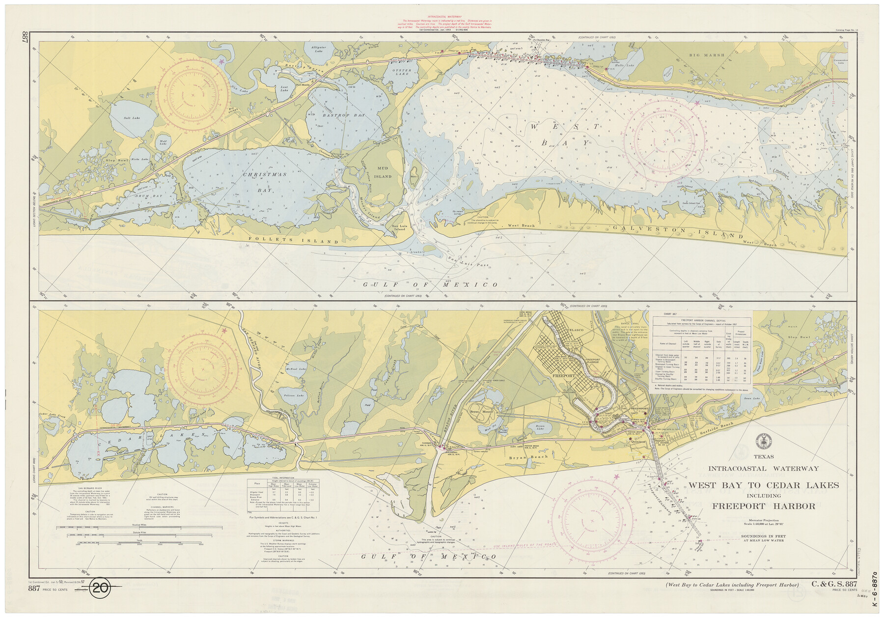
Intracoastal Waterway - West Bay to Cedar Lakes including Freeport Harbor
K-6-886a; K-6-887a
-
Map/Doc
69933
-
Collection
General Map Collection
-
Object Dates
6/24/1957 (Creation Date)
-
Counties
Galveston Brazoria
-
Subjects
Nautical Charts
-
Height x Width
27.2 x 38.6 inches
69.1 x 98.0 cm
-
Comments
dual-sided map
Part of: General Map Collection
Polk County Working Sketch 35

Print $20.00
- Digital $50.00
Polk County Working Sketch 35
1961
Size 16.7 x 12.1 inches
Map/Doc 71652
Erath County Working Sketch 33

Print $20.00
- Digital $50.00
Erath County Working Sketch 33
1972
Size 25.1 x 21.0 inches
Map/Doc 69114
South Part Brewster Co.

Print $40.00
- Digital $50.00
South Part Brewster Co.
1915
Size 39.2 x 51.8 inches
Map/Doc 4760
Panola County Sketch File 18

Print $20.00
- Digital $50.00
Panola County Sketch File 18
1909
Size 24.2 x 18.7 inches
Map/Doc 12138
Sutton County Rolled Sketch 70

Print $40.00
- Digital $50.00
Sutton County Rolled Sketch 70
Size 48.7 x 37.0 inches
Map/Doc 9982
Maverick County Sketch File 11

Print $40.00
- Digital $50.00
Maverick County Sketch File 11
1879
Size 8.3 x 8.8 inches
Map/Doc 31092
Leon County Rolled Sketch 3

Print $20.00
- Digital $50.00
Leon County Rolled Sketch 3
Size 16.8 x 22.5 inches
Map/Doc 6595
Flight Mission No. DIX-7P, Frame 14, Aransas County

Print $20.00
- Digital $50.00
Flight Mission No. DIX-7P, Frame 14, Aransas County
1956
Size 18.8 x 22.6 inches
Map/Doc 83866
Flight Mission No. DAH-9M, Frame 86, Orange County

Print $20.00
- Digital $50.00
Flight Mission No. DAH-9M, Frame 86, Orange County
1953
Size 18.4 x 22.2 inches
Map/Doc 86850
Irion County Working Sketch 6

Print $20.00
- Digital $50.00
Irion County Working Sketch 6
1935
Size 16.6 x 30.8 inches
Map/Doc 66415
Guadalupe County Sketch File 15b

Print $4.00
- Digital $50.00
Guadalupe County Sketch File 15b
1873
Size 10.3 x 8.4 inches
Map/Doc 24691

You may also like
Archer County Working Sketch 25

Print $20.00
- Digital $50.00
Archer County Working Sketch 25
Size 24.9 x 33.1 inches
Map/Doc 78188
El Paso County Working Sketch 21

Print $20.00
- Digital $50.00
El Paso County Working Sketch 21
1960
Size 37.8 x 30.9 inches
Map/Doc 69043
Sketch Showing Original Corners Affecting Block I and Adjacent Surveys from Actual Connections by W. D. Twichell

Print $20.00
- Digital $50.00
Sketch Showing Original Corners Affecting Block I and Adjacent Surveys from Actual Connections by W. D. Twichell
Size 23.6 x 24.5 inches
Map/Doc 90156
Greer County Sketch File 7

Print $40.00
- Digital $50.00
Greer County Sketch File 7
Size 12.8 x 17.5 inches
Map/Doc 24526
Sutton County Working Sketch 60

Print $20.00
- Digital $50.00
Sutton County Working Sketch 60
1959
Size 29.1 x 34.6 inches
Map/Doc 62403
Harbor of Brazos Santiago, Texas

Print $20.00
- Digital $50.00
Harbor of Brazos Santiago, Texas
1887
Size 27.1 x 18.3 inches
Map/Doc 72997
Harris County Sketch File 19

Print $4.00
- Digital $50.00
Harris County Sketch File 19
1862
Size 8.7 x 13.9 inches
Map/Doc 25366
Medina County Working Sketch 13

Print $20.00
- Digital $50.00
Medina County Working Sketch 13
1972
Size 31.5 x 39.0 inches
Map/Doc 70928
Terrell County Working Sketch 58

Print $40.00
- Digital $50.00
Terrell County Working Sketch 58
1960
Size 36.3 x 48.9 inches
Map/Doc 69579
Chambers County Rolled Sketch 24

Print $40.00
- Digital $50.00
Chambers County Rolled Sketch 24
1940
Size 38.2 x 49.9 inches
Map/Doc 8594
Comal County Working Sketch 9

Print $20.00
- Digital $50.00
Comal County Working Sketch 9
1972
Size 29.0 x 30.4 inches
Map/Doc 68175
Clay County Sketch File 8

Print $4.00
- Digital $50.00
Clay County Sketch File 8
1860
Size 5.5 x 8.3 inches
Map/Doc 18398