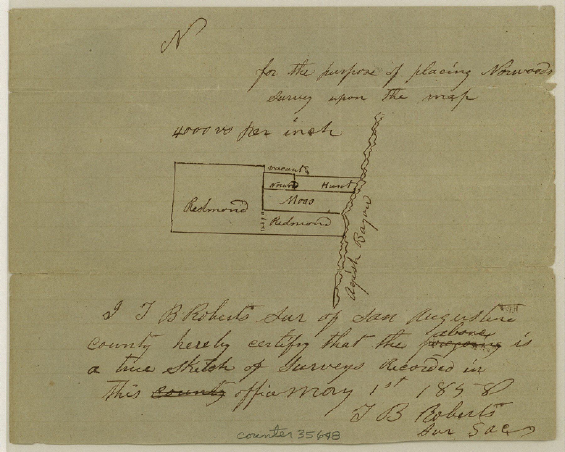
San Augustine County Sketch File 8
[Sketch of surveys on the west side of Ayish Bayou southwest from San Augustine]
-
Map/Doc
35648
-
Collection
General Map Collection
-
Object Dates
5/1/1858 (Creation Date)
6/28/1858 (File Date)
-
People and Organizations
T.B. Roberts (Surveyor/Engineer)
-
Counties
San Augustine
-
Subjects
Surveying Sketch File
-
Height x Width
6.2 x 7.8 inches
15.8 x 19.8 cm
-
Medium
paper, manuscript
-
Scale
1" = 4000 varas
-
Features
Ayish Bayou
Part of: General Map Collection
Jasper County Sketch File 1a

Print $8.00
- Digital $50.00
Jasper County Sketch File 1a
1859
Size 12.1 x 7.7 inches
Map/Doc 27765
Tarrant County Working Sketch 8

Print $20.00
- Digital $50.00
Tarrant County Working Sketch 8
1982
Size 33.2 x 19.7 inches
Map/Doc 62425
Pecos County Sketch File 64

Print $12.00
- Digital $50.00
Pecos County Sketch File 64
1919
Size 11.1 x 8.8 inches
Map/Doc 33818
Map of Wood County

Print $20.00
- Digital $50.00
Map of Wood County
1872
Size 15.6 x 16.8 inches
Map/Doc 4167
Flight Mission No. DCL-7C, Frame 58, Kenedy County

Print $20.00
- Digital $50.00
Flight Mission No. DCL-7C, Frame 58, Kenedy County
1943
Size 15.3 x 15.1 inches
Map/Doc 86046

Reagan County Rolled Sketch 21A

Print $20.00
- Digital $50.00
Reagan County Rolled Sketch 21A
1950
Size 34.8 x 43.4 inches
Map/Doc 9816
Burnet County Sketch File 42

Print $28.00
- Digital $50.00
Burnet County Sketch File 42
1950
Size 9.9 x 8.8 inches
Map/Doc 16760
Flight Mission No. CGN-3P, Frame 141, San Patricio County

Print $20.00
- Digital $50.00
Flight Mission No. CGN-3P, Frame 141, San Patricio County
1956
Size 18.6 x 22.4 inches
Map/Doc 86985
Falls County Sketch File 5

Print $9.00
- Digital $50.00
Falls County Sketch File 5
1857
Size 12.5 x 8.7 inches
Map/Doc 22337
Starr County Boundary File 1a

Print $20.00
- Digital $50.00
Starr County Boundary File 1a
Size 22.4 x 41.0 inches
Map/Doc 58813
Flight Mission No. DQN-2K, Frame 10, Calhoun County

Print $20.00
- Digital $50.00
Flight Mission No. DQN-2K, Frame 10, Calhoun County
1953
Size 18.5 x 22.0 inches
Map/Doc 84227
You may also like
Map of east portion of Matagorda Bay in Matagorda County showing subdivision for mineral development

Print $40.00
- Digital $50.00
Map of east portion of Matagorda Bay in Matagorda County showing subdivision for mineral development
Size 33.0 x 52.8 inches
Map/Doc 65809
Anderson County Working Sketch 3

Print $20.00
- Digital $50.00
Anderson County Working Sketch 3
Size 15.4 x 14.1 inches
Map/Doc 67002
Comal County Working Sketch 1

Print $20.00
- Digital $50.00
Comal County Working Sketch 1
1919
Size 22.1 x 18.2 inches
Map/Doc 68167
Uvalde County Sketch File 24

Print $42.00
- Digital $50.00
Uvalde County Sketch File 24
1926
Size 19.4 x 29.9 inches
Map/Doc 12536
Kimble County Sketch File 31

Print $20.00
- Digital $50.00
Kimble County Sketch File 31
1890
Size 26.0 x 24.3 inches
Map/Doc 11929
Young County Sketch File 22

Print $20.00
- Digital $50.00
Young County Sketch File 22
1957
Size 22.9 x 19.8 inches
Map/Doc 12716
Plat Compiled by W. J. Williams, Plainview, Texas, and Sylvan Sanders, Lubbock, Texas Showing Position of Original and Re-Survey Corners in Lynn, Terry, Yoakum, Gaines and Dawson Counties, Texas

Print $40.00
- Digital $50.00
Plat Compiled by W. J. Williams, Plainview, Texas, and Sylvan Sanders, Lubbock, Texas Showing Position of Original and Re-Survey Corners in Lynn, Terry, Yoakum, Gaines and Dawson Counties, Texas
1946
Size 57.6 x 22.9 inches
Map/Doc 89689
Nueces County Sketch File 26 1/2

Print $20.00
- Digital $50.00
Nueces County Sketch File 26 1/2
1902
Size 18.4 x 23.0 inches
Map/Doc 42186
Bee County Working Sketch 8

Print $20.00
- Digital $50.00
Bee County Working Sketch 8
1939
Size 18.0 x 20.5 inches
Map/Doc 67258
Coleman County Sketch File 32

Print $4.00
- Digital $50.00
Coleman County Sketch File 32
Size 12.8 x 8.4 inches
Map/Doc 18723
[Leagues 27, 28, 69, 70, 71, 72, and 73]
![91097, [Leagues 27, 28, 69, 70, 71, 72, and 73], Twichell Survey Records](https://historictexasmaps.com/wmedia_w700/maps/91097-1.tif.jpg)
Print $20.00
- Digital $50.00
[Leagues 27, 28, 69, 70, 71, 72, and 73]
Size 23.8 x 16.3 inches
Map/Doc 91097
Hutchinson County Rolled Sketch 44-1

Print $20.00
- Digital $50.00
Hutchinson County Rolled Sketch 44-1
2002
Size 24.0 x 36.0 inches
Map/Doc 77537