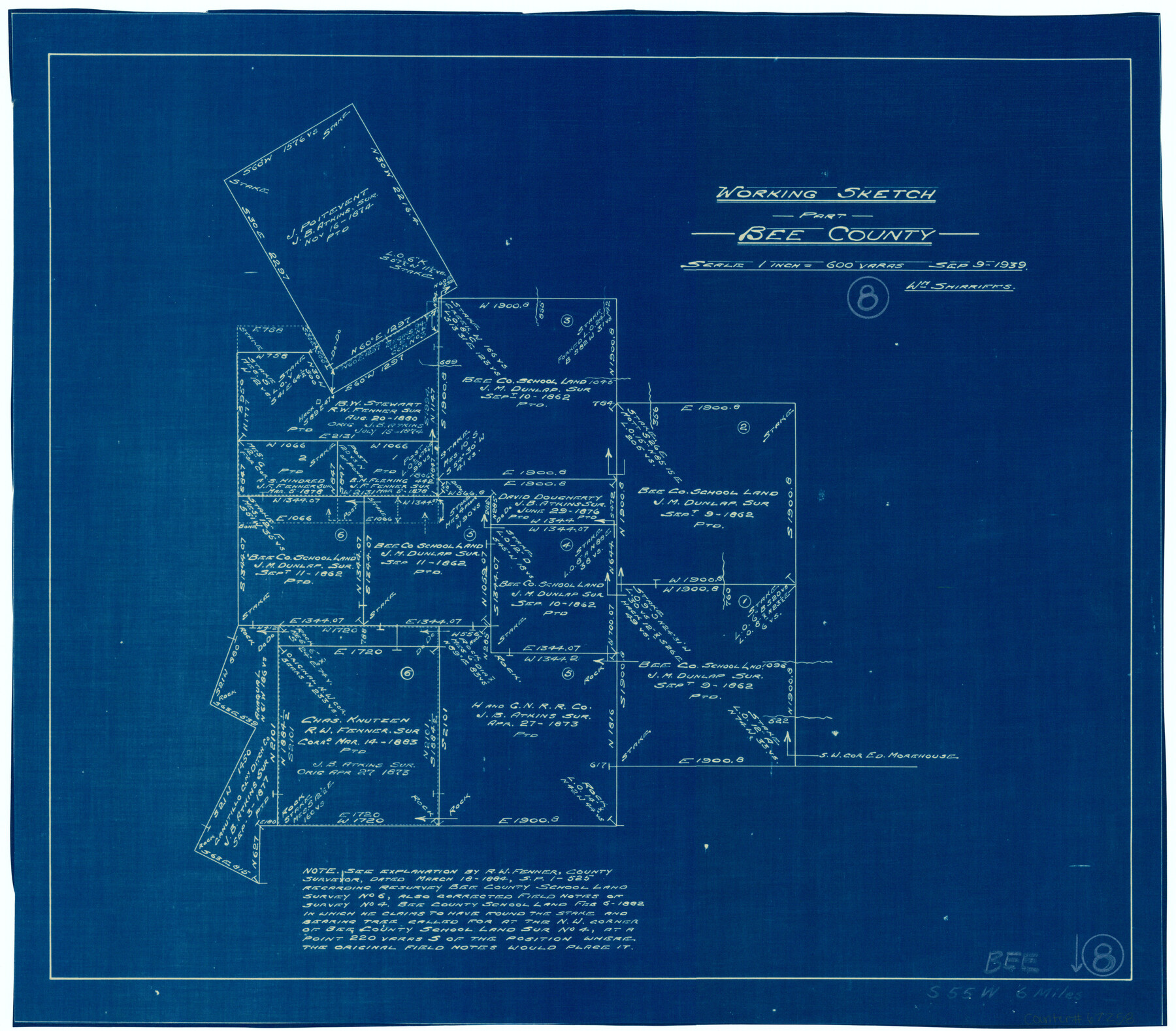
Bee County Working Sketch 8
-
Map/Doc
67258
-
Collection
General Map Collection
-
Object Dates
9/9/1939 (Creation Date)
-
People and Organizations
William Shirriffs (Draftsman)
-
Counties
Bee
-
Subjects
Surveying Working Sketch
-
Height x Width
18.0 x 20.5 inches
45.7 x 52.1 cm
-
Scale
1" = 600 varas
-
Comments
Surveys located about six miles South 55 degrees West of Beeville, Texas.
Part of: General Map Collection
Upton County Rolled Sketch 19

Print $40.00
- Digital $50.00
Upton County Rolled Sketch 19
1933
Size 55.2 x 40.0 inches
Map/Doc 10040
Wilbarger County Boundary File 1b

Print $40.00
- Digital $50.00
Wilbarger County Boundary File 1b
Size 14.3 x 8.8 inches
Map/Doc 59943
Starr County Sketch File 52

Print $4.00
- Digital $50.00
Starr County Sketch File 52
Size 13.9 x 9.0 inches
Map/Doc 37011
Blanco County Sketch File 21

Print $6.00
- Digital $50.00
Blanco County Sketch File 21
1881
Size 15.6 x 11.2 inches
Map/Doc 14600
Aransas County Sketch File 34

Print $54.00
- Digital $50.00
Aransas County Sketch File 34
1919
Size 14.3 x 8.5 inches
Map/Doc 13320
Collin County Boundary File 1

Print $8.00
- Digital $50.00
Collin County Boundary File 1
Size 12.7 x 8.1 inches
Map/Doc 51678
[Surveys in Mills, Hamilton, Coryell and Bell Counties]
![78362, [Surveys in Mills, Hamilton, Coryell and Bell Counties], General Map Collection](https://historictexasmaps.com/wmedia_w700/maps/78362.tif.jpg)
Print $20.00
- Digital $50.00
[Surveys in Mills, Hamilton, Coryell and Bell Counties]
Size 33.9 x 19.5 inches
Map/Doc 78362
Coke County Rolled Sketch 11

Print $20.00
- Digital $50.00
Coke County Rolled Sketch 11
1949
Size 32.6 x 26.3 inches
Map/Doc 5512
Reeves County Working Sketch 16

Print $40.00
- Digital $50.00
Reeves County Working Sketch 16
1961
Size 30.8 x 48.8 inches
Map/Doc 63459
Brewster County Working Sketch 112

Print $20.00
- Digital $50.00
Brewster County Working Sketch 112
1982
Size 28.1 x 26.8 inches
Map/Doc 67712
Loving County Working Sketch 16a

Print $20.00
- Digital $50.00
Loving County Working Sketch 16a
1976
Size 45.4 x 29.3 inches
Map/Doc 70650
Hudspeth County Working Sketch 12

Print $20.00
- Digital $50.00
Hudspeth County Working Sketch 12
1948
Size 18.2 x 38.6 inches
Map/Doc 66294
You may also like
[Sketch for Mineral Application 13439 - Bed Lost Lake, Walle Merritt]
![65578, [Sketch for Mineral Application 13439 - Bed Lost Lake, Walle Merritt], General Map Collection](https://historictexasmaps.com/wmedia_w700/maps/65578.tif.jpg)
Print $20.00
- Digital $50.00
[Sketch for Mineral Application 13439 - Bed Lost Lake, Walle Merritt]
1925
Size 31.0 x 29.6 inches
Map/Doc 65578
Sutton County Boundary File 5a

Print $20.00
- Digital $50.00
Sutton County Boundary File 5a
Size 14.5 x 8.9 inches
Map/Doc 59060
[Sketch showing area sued for near Block 194, Yates survey 34 1/2 and Runnels County School Land]
![91685, [Sketch showing area sued for near Block 194, Yates survey 34 1/2 and Runnels County School Land], Twichell Survey Records](https://historictexasmaps.com/wmedia_w700/maps/91685-1.tif.jpg)
Print $20.00
- Digital $50.00
[Sketch showing area sued for near Block 194, Yates survey 34 1/2 and Runnels County School Land]
Size 17.4 x 12.5 inches
Map/Doc 91685
General Highway Map, Galveston County, Texas

Print $20.00
General Highway Map, Galveston County, Texas
1939
Size 18.5 x 25.0 inches
Map/Doc 79096
Zavalla County

Print $20.00
- Digital $50.00
Zavalla County
1879
Size 21.3 x 25.0 inches
Map/Doc 4645
Ward County Boundary File 3a

Print $22.00
- Digital $50.00
Ward County Boundary File 3a
Size 13.1 x 8.6 inches
Map/Doc 59684
A new & correct map of Texas compiled from the most recent surveys & authorities to the year 1845

Print $20.00
- Digital $50.00
A new & correct map of Texas compiled from the most recent surveys & authorities to the year 1845
1845
Size 22.4 x 28.5 inches
Map/Doc 96973
Dawson County Working Sketch 2

Print $20.00
- Digital $50.00
Dawson County Working Sketch 2
1937
Size 8.8 x 20.3 inches
Map/Doc 68546
Bee County Sketch File Y

Print $4.00
- Digital $50.00
Bee County Sketch File Y
Size 8.8 x 5.4 inches
Map/Doc 14255
San Patricio County Aerial Photograph Index Sheet 5

Print $20.00
- Digital $50.00
San Patricio County Aerial Photograph Index Sheet 5
1957
Size 23.9 x 19.2 inches
Map/Doc 83747
Williamson County Working Sketch 18

Print $20.00
- Digital $50.00
Williamson County Working Sketch 18
1985
Size 26.1 x 26.6 inches
Map/Doc 72578
Pecos County Rolled Sketch 168

Print $40.00
- Digital $50.00
Pecos County Rolled Sketch 168
Size 73.5 x 44.7 inches
Map/Doc 9748