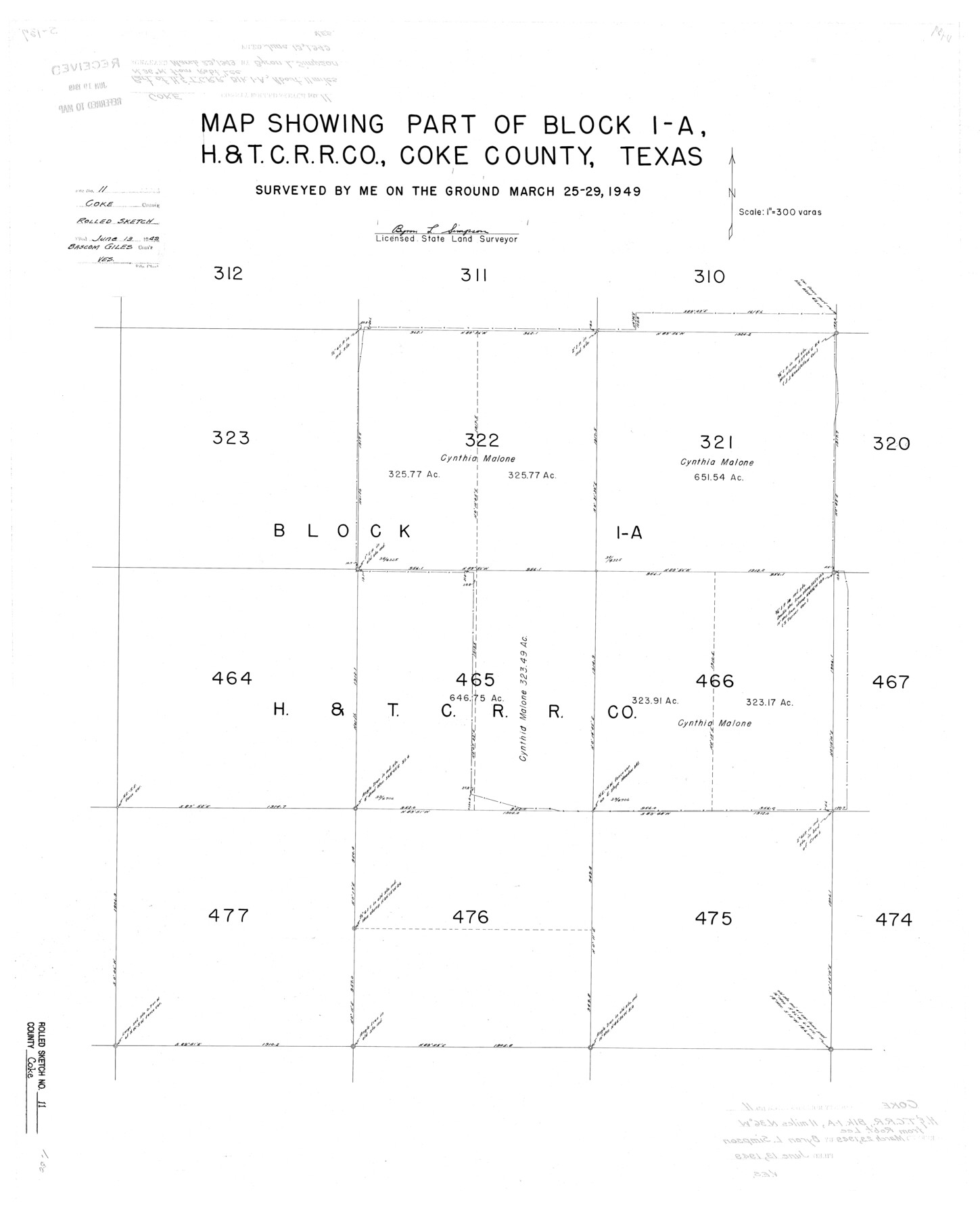
Coke County Rolled Sketch 11
Map showing part of Block 1-A, H. & T. C. R.R. Co., Coke County, Texas
-
Map/Doc
5512
-
Collection
General Map Collection
-
Object Dates
1949/3/29 (Creation Date)
1949/6/13 (File Date)
-
People and Organizations
Byron L. Simpson (Surveyor/Engineer)
-
Counties
Coke
-
Subjects
Surveying Rolled Sketch
-
Height x Width
32.6 x 26.3 inches
82.8 x 66.8 cm
-
Scale
1" = 300 varas
Part of: General Map Collection

Map of Denton County

Print $20.00
- Digital $50.00
Map of Denton County
1896
Size 25.6 x 22.0 inches
Map/Doc 11311
Trinity County Sketch File 38

Print $8.00
- Digital $50.00
Trinity County Sketch File 38
1948
Size 14.5 x 8.9 inches
Map/Doc 38593
Travis County Appraisal District Plat Map 2_1002

Print $20.00
- Digital $50.00
Travis County Appraisal District Plat Map 2_1002
Size 21.4 x 26.5 inches
Map/Doc 94230
Bandera County Working Sketch 14

Print $20.00
- Digital $50.00
Bandera County Working Sketch 14
1934
Size 28.0 x 30.9 inches
Map/Doc 67607
Aransas County Boundary File 7

Print $2.00
- Digital $50.00
Aransas County Boundary File 7
Size 8.8 x 14.2 inches
Map/Doc 50042
Matagorda County Sketch File 4

Print $4.00
- Digital $50.00
Matagorda County Sketch File 4
1876
Size 7.9 x 12.8 inches
Map/Doc 30734
Terrell County Working Sketch 70

Print $20.00
- Digital $50.00
Terrell County Working Sketch 70
1979
Size 39.0 x 36.5 inches
Map/Doc 69591
Gulf Oil Corp. Fishgide - Port Isabel

Gulf Oil Corp. Fishgide - Port Isabel
1960
Size 22.0 x 11.9 inches
Map/Doc 75980
Flight Mission No. CRC-4R, Frame 75, Chambers County

Print $20.00
- Digital $50.00
Flight Mission No. CRC-4R, Frame 75, Chambers County
1956
Size 18.6 x 22.3 inches
Map/Doc 84879
Jeff Davis County Sketch File 28

Print $30.00
- Digital $50.00
Jeff Davis County Sketch File 28
1916
Size 7.2 x 8.7 inches
Map/Doc 28003
Flight Mission No. BRE-2P, Frame 70, Nueces County

Print $20.00
- Digital $50.00
Flight Mission No. BRE-2P, Frame 70, Nueces County
1956
Size 18.5 x 22.6 inches
Map/Doc 86765
You may also like
Young County Working Sketch 25

Print $20.00
- Digital $50.00
Young County Working Sketch 25
1982
Size 12.6 x 14.4 inches
Map/Doc 62048
Cameron County Sketch File 10

Print $8.00
- Digital $50.00
Cameron County Sketch File 10
1989
Size 11.1 x 8.6 inches
Map/Doc 17205
Jasper County Working Sketch 28

Print $20.00
- Digital $50.00
Jasper County Working Sketch 28
1955
Size 22.6 x 15.6 inches
Map/Doc 66490
[Sketch of part of G. & M. Block 5, G. & M. Block 4, Block M19 and Block 21W]
![93092, [Sketch of part of G. & M. Block 5, G. & M. Block 4, Block M19 and Block 21W], Twichell Survey Records](https://historictexasmaps.com/wmedia_w700/maps/93092-1.tif.jpg)
Print $20.00
- Digital $50.00
[Sketch of part of G. & M. Block 5, G. & M. Block 4, Block M19 and Block 21W]
Size 22.6 x 17.7 inches
Map/Doc 93092
Coke County Working Sketch 4

Print $20.00
- Digital $50.00
Coke County Working Sketch 4
1897
Size 15.6 x 16.4 inches
Map/Doc 68041
Hardeman County Sketch File 12

Print $4.00
- Digital $50.00
Hardeman County Sketch File 12
Size 12.8 x 8.3 inches
Map/Doc 25020
Sulphur River, Terry Lake Sheet

Print $20.00
- Digital $50.00
Sulphur River, Terry Lake Sheet
1919
Size 15.7 x 18.3 inches
Map/Doc 78337
Frio County Rolled Sketch 15

Print $20.00
- Digital $50.00
Frio County Rolled Sketch 15
1949
Size 26.1 x 39.0 inches
Map/Doc 5922
Trinity County Working Sketch 4

Print $20.00
- Digital $50.00
Trinity County Working Sketch 4
1908
Size 21.3 x 18.5 inches
Map/Doc 69452
Morris County Rolled Sketch 2A

Print $20.00
- Digital $50.00
Morris County Rolled Sketch 2A
Size 24.0 x 18.8 inches
Map/Doc 10273
Flight Mission No. DQO-8K, Frame 143, Galveston County

Print $20.00
- Digital $50.00
Flight Mission No. DQO-8K, Frame 143, Galveston County
1952
Size 18.6 x 22.5 inches
Map/Doc 85205
Clay County Boundary File 14

Print $80.00
- Digital $50.00
Clay County Boundary File 14
Size 63.1 x 15.4 inches
Map/Doc 51416