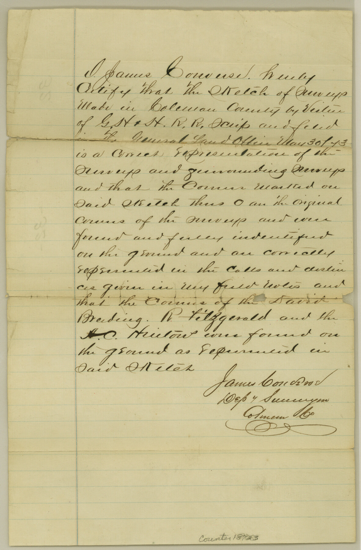
Coleman County Sketch File 32
[Surveyor's statement regarding sketch of G. H. & H. R.R. Co. surveys in north part of the county]
-
Map/Doc
18723
-
Collection
General Map Collection
-
Object Dates
1874/10/26 (File Date)
-
People and Organizations
James Converse (Surveyor/Engineer)
-
Counties
Coleman
-
Subjects
Surveying Sketch File
-
Height x Width
12.8 x 8.4 inches
32.5 x 21.3 cm
-
Medium
paper, manuscript
Part of: General Map Collection
Map of Shackelford County, North of the Clearfork of the Brazos River Young - South of il Milam - Land District

Print $20.00
- Digital $50.00
Map of Shackelford County, North of the Clearfork of the Brazos River Young - South of il Milam - Land District
1859
Size 24.8 x 19.9 inches
Map/Doc 4027
Presidio County Working Sketch 45

Print $20.00
- Digital $50.00
Presidio County Working Sketch 45
Size 25.2 x 20.0 inches
Map/Doc 71722
Kendall County Sketch File 9

Print $6.00
- Digital $50.00
Kendall County Sketch File 9
1879
Size 4.6 x 9.3 inches
Map/Doc 28692
Flight Mission No. DAG-21K, Frame 31, Matagorda County

Print $20.00
- Digital $50.00
Flight Mission No. DAG-21K, Frame 31, Matagorda County
1952
Size 18.7 x 22.4 inches
Map/Doc 86398
Red River County Sketch File 9

Print $10.00
- Digital $50.00
Red River County Sketch File 9
1862
Size 12.6 x 8.2 inches
Map/Doc 35117
Burnet County Working Sketch 10

Print $20.00
- Digital $50.00
Burnet County Working Sketch 10
1975
Size 18.6 x 20.3 inches
Map/Doc 67853
Leon County Rolled Sketch 7

Print $40.00
- Digital $50.00
Leon County Rolled Sketch 7
1954
Size 55.9 x 35.0 inches
Map/Doc 9428
Erath County Sketch File 35

Print $8.00
- Digital $50.00
Erath County Sketch File 35
1992
Size 14.5 x 8.8 inches
Map/Doc 22326

Port Facilities at Texas City, Tex.

Print $20.00
- Digital $50.00
Port Facilities at Texas City, Tex.
1924
Size 13.9 x 15.9 inches
Map/Doc 97161
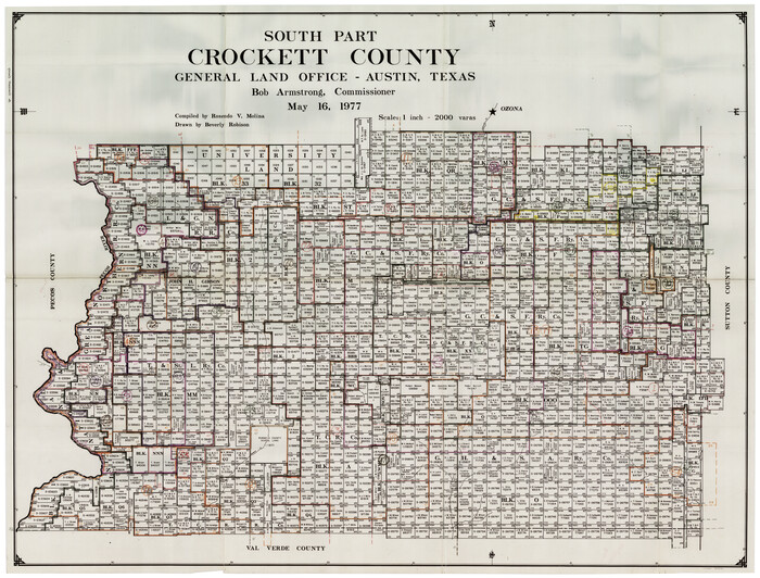
Crockett County Working Sketch Graphic Index - south part
Print $40.00
- Digital $50.00
Crockett County Working Sketch Graphic Index - south part
1977
Size 38.2 x 50.0 inches
Map/Doc 76512
Wise County Sketch File 32

Print $5.00
- Digital $50.00
Wise County Sketch File 32
1880
Size 16.4 x 11.0 inches
Map/Doc 40588
You may also like
[Blocks T2, T3, and K13]
![90989, [Blocks T2, T3, and K13], Twichell Survey Records](https://historictexasmaps.com/wmedia_w700/maps/90989-1.tif.jpg)
Print $20.00
- Digital $50.00
[Blocks T2, T3, and K13]
Size 20.6 x 19.8 inches
Map/Doc 90989
Sectional Map of the Eastern Half of Texas traversed by the Missouri, Kansas & Texas Railway, showing the crops adapted to each section, with the elevation and average annual rainfall

Print $20.00
- Digital $50.00
Sectional Map of the Eastern Half of Texas traversed by the Missouri, Kansas & Texas Railway, showing the crops adapted to each section, with the elevation and average annual rainfall
Size 18.3 x 14.7 inches
Map/Doc 96602
Supplemental Plat, T. 4S., R. 14W., Indian Meridian, Oklahoma

Print $4.00
- Digital $50.00
Supplemental Plat, T. 4S., R. 14W., Indian Meridian, Oklahoma
1924
Size 17.4 x 23.1 inches
Map/Doc 75148
Dickens County Rolled Sketch N

Print $20.00
- Digital $50.00
Dickens County Rolled Sketch N
1909
Size 21.2 x 30.6 inches
Map/Doc 5714
Liberty County Sketch File 20

Print $6.00
- Digital $50.00
Liberty County Sketch File 20
Size 7.8 x 9.9 inches
Map/Doc 29925
Crockett County Sketch File 81

Print $4.00
- Digital $50.00
Crockett County Sketch File 81
1939
Size 11.3 x 8.5 inches
Map/Doc 19893
The Republic County of San Patricio. Proposed, Late Fall 1837

Print $20.00
The Republic County of San Patricio. Proposed, Late Fall 1837
2020
Size 17.8 x 21.7 inches
Map/Doc 96273
Morton Independent School District, Cochran County, Texas

Print $20.00
- Digital $50.00
Morton Independent School District, Cochran County, Texas
Size 26.3 x 23.9 inches
Map/Doc 92519
Flight Mission No. CRK-7P, Frame 133, Refugio County

Print $20.00
- Digital $50.00
Flight Mission No. CRK-7P, Frame 133, Refugio County
1956
Size 18.3 x 22.1 inches
Map/Doc 86956
Flight Mission No. DQN-1K, Frame 139, Calhoun County

Print $20.00
- Digital $50.00
Flight Mission No. DQN-1K, Frame 139, Calhoun County
1953
Size 18.4 x 22.3 inches
Map/Doc 84202
Nueces County Rolled Sketch 39

Print $20.00
- Digital $50.00
Nueces County Rolled Sketch 39
1957
Size 32.9 x 45.3 inches
Map/Doc 6879
Flight Mission No. BRA-16M, Frame 173, Jefferson County

Print $20.00
- Digital $50.00
Flight Mission No. BRA-16M, Frame 173, Jefferson County
1953
Size 18.5 x 22.2 inches
Map/Doc 85771