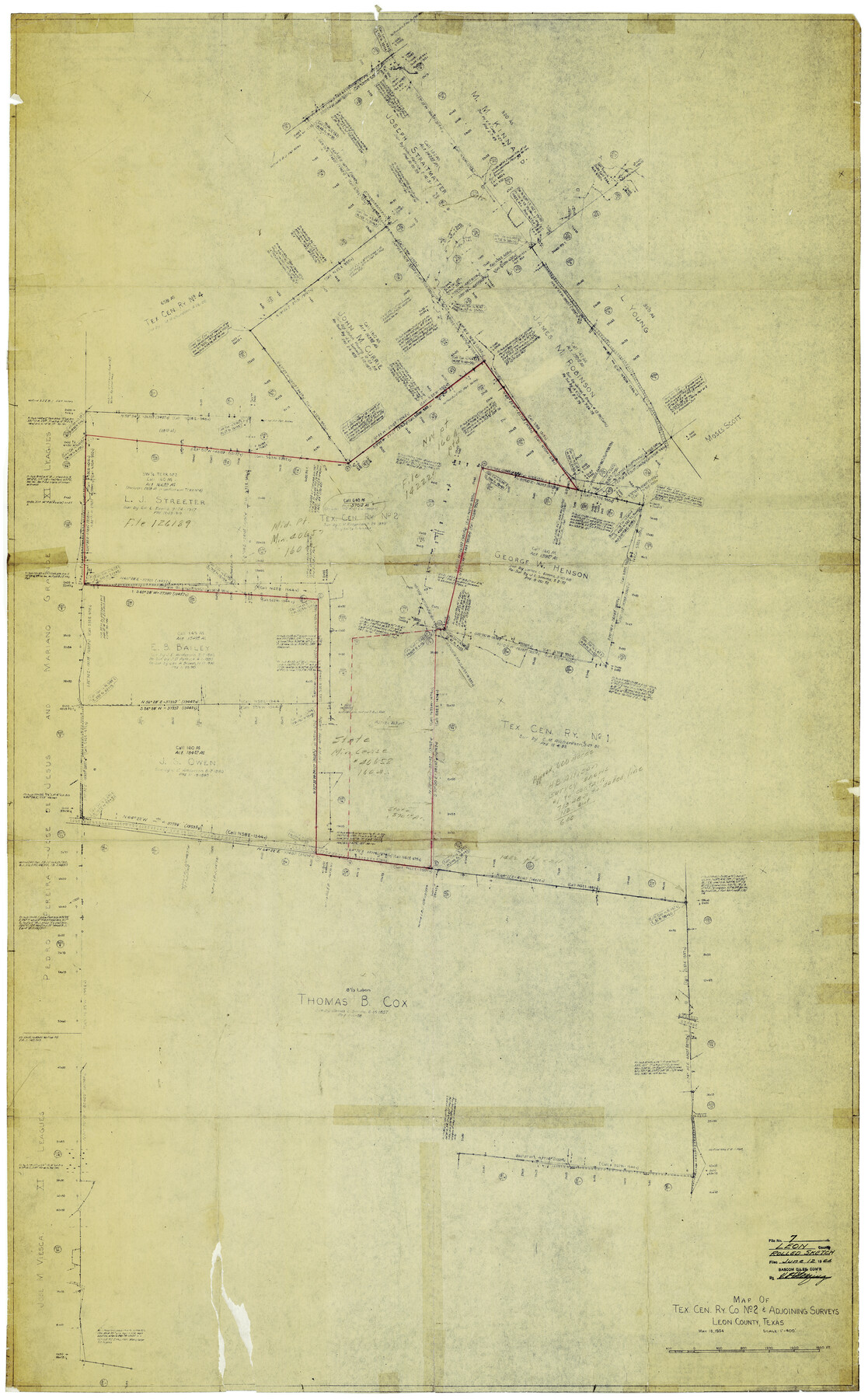
Leon County Rolled Sketch 7
Map of Tex. Cen. Ry. Co. no. 2 & adjoining surveys
-
Map/Doc
9428
-
Collection
General Map Collection
-
Object Dates
5/18/1954 (Creation Date)
6/12/1954 (File Date)
-
Counties
Leon
-
Subjects
Surveying Rolled Sketch
-
Height x Width
55.9 x 35.0 inches
142.0 x 88.9 cm
-
Medium
blueprint/diazo
-
Scale
1" = 400 feet
Part of: General Map Collection
Nueces County Rolled Sketch 4

Print $20.00
- Digital $50.00
Nueces County Rolled Sketch 4
1910
Size 39.8 x 38.5 inches
Map/Doc 9583
Hardeman County Sketch File 2

Print $6.00
- Digital $50.00
Hardeman County Sketch File 2
1879
Size 9.0 x 7.7 inches
Map/Doc 24984
Wharton County Sketch File 4

Print $20.00
- Digital $50.00
Wharton County Sketch File 4
Size 26.9 x 16.2 inches
Map/Doc 12659

Hood County Rolled Sketch 3

Print $20.00
- Digital $50.00
Hood County Rolled Sketch 3
1967
Size 33.2 x 36.2 inches
Map/Doc 9179
Brewster County Rolled Sketch 156

Print $156.00
- Digital $50.00
Brewster County Rolled Sketch 156
2005
Map/Doc 85390
Kimble County Working Sketch 67

Print $20.00
- Digital $50.00
Kimble County Working Sketch 67
1965
Size 20.7 x 34.5 inches
Map/Doc 70135
Starr County Working Sketch 11

Print $20.00
- Digital $50.00
Starr County Working Sketch 11
1944
Size 18.1 x 17.7 inches
Map/Doc 63927
Hudspeth County Working Sketch 47

Print $20.00
- Digital $50.00
Hudspeth County Working Sketch 47
1984
Size 27.3 x 38.6 inches
Map/Doc 78211
Jefferson County Rolled Sketch 45

Print $20.00
- Digital $50.00
Jefferson County Rolled Sketch 45
1959
Size 31.2 x 27.3 inches
Map/Doc 6402
Erath County Sketch File 2

Print $20.00
- Digital $50.00
Erath County Sketch File 2
Size 13.2 x 15.5 inches
Map/Doc 11463

You may also like
![90608, [Block K11], Twichell Survey Records](https://historictexasmaps.com/wmedia_w700/maps/90608-1.tif.jpg)
Fayette County Boundary File 3

Print $29.00
- Digital $50.00
Fayette County Boundary File 3
Size 14.4 x 9.0 inches
Map/Doc 53348

Louisiana and Texas Intracoastal Waterway

Print $20.00
- Digital $50.00
Louisiana and Texas Intracoastal Waterway
1929
Size 13.6 x 19.6 inches
Map/Doc 83342
Upshur County Working Sketch 15, revised

Print $20.00
- Digital $50.00
Upshur County Working Sketch 15, revised
1996
Size 43.3 x 37.4 inches
Map/Doc 78217
Jackson County Boundary File 2

Print $22.00
- Digital $50.00
Jackson County Boundary File 2
Size 8.6 x 4.1 inches
Map/Doc 55437
Freestone County Working Sketch 7

Print $20.00
- Digital $50.00
Freestone County Working Sketch 7
1951
Size 32.8 x 24.4 inches
Map/Doc 69249
Map of Harris County

Print $20.00
- Digital $50.00
Map of Harris County
1893
Size 26.9 x 36.5 inches
Map/Doc 66855
Brewster County Rolled Sketch 59AA

Print $20.00
- Digital $50.00
Brewster County Rolled Sketch 59AA
1931
Size 19.2 x 24.0 inches
Map/Doc 5228
Moore County Working Sketch 10

Print $20.00
- Digital $50.00
Moore County Working Sketch 10
1951
Size 34.9 x 31.5 inches
Map/Doc 71192
[Sketch showing the area around the state line in Roberts and Clay Counties, along the north bank of the Canadian River]
![91762, [Sketch showing the area around the state line in Roberts and Clay Counties, along the north bank of the Canadian River], Twichell Survey Records](https://historictexasmaps.com/wmedia_w700/maps/91762-1.tif.jpg)
Print $20.00
- Digital $50.00
[Sketch showing the area around the state line in Roberts and Clay Counties, along the north bank of the Canadian River]
1901
Size 14.3 x 12.7 inches
Map/Doc 91762
Uvalde County Rolled Sketch 23

Print $20.00
- Digital $50.00
Uvalde County Rolled Sketch 23
2008
Size 24.6 x 32.6 inches
Map/Doc 89024