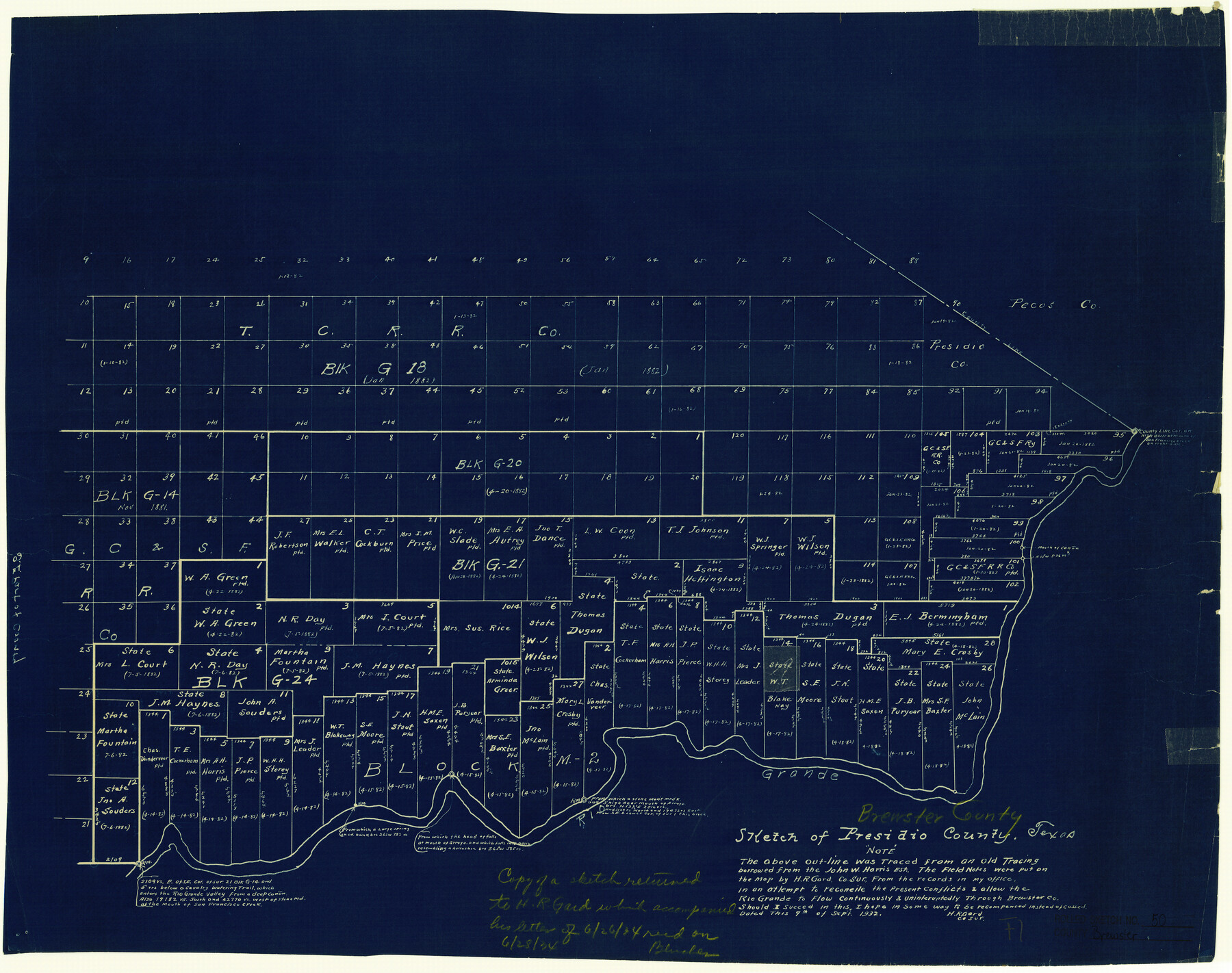
Brewster County Rolled Sketch 50
Sketch of Brewster County, Texas [Block G18, T. C. R.R. Co. and south to the Rio Grande]
-
Map/Doc
5226
-
Collection
General Map Collection
-
Object Dates
1932/9/9 (Creation Date)
1934/6/28 (File Date)
-
People and Organizations
H.R. Gard (Surveyor/Engineer)
-
Counties
Brewster
-
Subjects
Surveying Rolled Sketch
-
Height x Width
21.0 x 26.6 inches
53.3 x 67.6 cm
-
Medium
blueprint/diazo
-
Comments
See Brewster County Rolled Sketch 126 (43230) for surveyor’s report.
Related maps
Brewster County Rolled Sketch 126

Print $225.00
- Digital $50.00
Brewster County Rolled Sketch 126
1908
Map/Doc 43230
Part of: General Map Collection
Donley County Sketch File 4

Print $28.00
- Digital $50.00
Donley County Sketch File 4
1881
Size 12.8 x 8.3 inches
Map/Doc 21219
Galveston County NRC Article 33.136 Sketch 87

Print $24.00
- Digital $50.00
Galveston County NRC Article 33.136 Sketch 87
2006
Size 24.0 x 36.0 inches
Map/Doc 95391
Winkler County Working Sketch 10

Print $40.00
- Digital $50.00
Winkler County Working Sketch 10
1960
Size 30.3 x 61.0 inches
Map/Doc 72604
McMullen County Working Sketch 13

Print $20.00
- Digital $50.00
McMullen County Working Sketch 13
1938
Size 27.2 x 21.6 inches
Map/Doc 70714
Rio Grande, Hargill Sheet

Print $20.00
- Digital $50.00
Rio Grande, Hargill Sheet
1935
Size 37.1 x 38.1 inches
Map/Doc 65121
Brown County Working Sketch 1

Print $20.00
- Digital $50.00
Brown County Working Sketch 1
1918
Size 20.3 x 29.0 inches
Map/Doc 67766
Lynn County Boundary File 9a

Print $80.00
- Digital $50.00
Lynn County Boundary File 9a
Size 9.3 x 6.4 inches
Map/Doc 56669
Shelby County Sketch File 31

Print $20.00
- Digital $50.00
Shelby County Sketch File 31
1949
Size 12.0 x 36.0 inches
Map/Doc 12320
University Lands Blocks 29-33, Crockett County, Texas

Print $20.00
- Digital $50.00
University Lands Blocks 29-33, Crockett County, Texas
1936
Size 29.8 x 42.7 inches
Map/Doc 2443
Reagan County Working Sketch 39

Print $20.00
- Digital $50.00
Reagan County Working Sketch 39
1971
Size 22.5 x 36.1 inches
Map/Doc 71881
Starr County Sketch File 44

Print $8.00
- Digital $50.00
Starr County Sketch File 44
1944
Size 14.1 x 8.8 inches
Map/Doc 36995
Hardin County Sketch File 9a

Print $4.00
- Digital $50.00
Hardin County Sketch File 9a
1860
Size 9.9 x 8.4 inches
Map/Doc 25108
You may also like
General Highway Map. Detail of Cities and Towns in Orange County, Texas [Orange and vicinity]
![79622, General Highway Map. Detail of Cities and Towns in Orange County, Texas [Orange and vicinity], Texas State Library and Archives](https://historictexasmaps.com/wmedia_w700/maps/79622.tif.jpg)
Print $20.00
General Highway Map. Detail of Cities and Towns in Orange County, Texas [Orange and vicinity]
1961
Size 18.1 x 24.4 inches
Map/Doc 79622
Williamson County Sketch File 14

Print $6.00
- Digital $50.00
Williamson County Sketch File 14
1871
Size 9.4 x 15.4 inches
Map/Doc 40332
Right of Way and Track Map Texas & New Orleans R.R. Co. operated by the T. & N. O. R.R. Co. Dallas-Sabine Branch

Print $40.00
- Digital $50.00
Right of Way and Track Map Texas & New Orleans R.R. Co. operated by the T. & N. O. R.R. Co. Dallas-Sabine Branch
1918
Size 26.4 x 56.7 inches
Map/Doc 64154
Gonzales County

Print $40.00
- Digital $50.00
Gonzales County
1986
Size 39.9 x 52.0 inches
Map/Doc 77292
Anderson County Working Sketch 44

Print $20.00
- Digital $50.00
Anderson County Working Sketch 44
1991
Size 27.7 x 32.3 inches
Map/Doc 67044
Official Copy of the Map of Milam County made for the International and G. N. R. R. Co.

Print $20.00
- Digital $50.00
Official Copy of the Map of Milam County made for the International and G. N. R. R. Co.
1877
Size 23.9 x 22.5 inches
Map/Doc 581
Plat Compiled by W.J. Williams, Plainview, Texas, and Sylvan Sanders, Lubbock, Texas Showing Position of Original and Re-Survey Corners in Lynn, Terry, Yoakum, Gaines, and Dawson Counties, Texas

Print $40.00
- Digital $50.00
Plat Compiled by W.J. Williams, Plainview, Texas, and Sylvan Sanders, Lubbock, Texas Showing Position of Original and Re-Survey Corners in Lynn, Terry, Yoakum, Gaines, and Dawson Counties, Texas
1946
Size 56.6 x 22.6 inches
Map/Doc 89628
Copy of sketch in Nacogdoches Donation 724 on file in GLO

Print $20.00
- Digital $50.00
Copy of sketch in Nacogdoches Donation 724 on file in GLO
1890
Size 18.0 x 10.9 inches
Map/Doc 75803
Young County Working Sketch 16

Print $20.00
- Digital $50.00
Young County Working Sketch 16
1955
Size 23.8 x 21.7 inches
Map/Doc 62039
Bowie County Working Sketch 12

Print $20.00
- Digital $50.00
Bowie County Working Sketch 12
1959
Size 31.3 x 23.3 inches
Map/Doc 67416
Map of Jackson County Texas

Print $20.00
- Digital $50.00
Map of Jackson County Texas
1840
Size 29.6 x 23.2 inches
Map/Doc 3708
[Sketch showing Block M-3]
![91708, [Sketch showing Block M-3], Twichell Survey Records](https://historictexasmaps.com/wmedia_w700/maps/91708-1.tif.jpg)
Print $20.00
- Digital $50.00
[Sketch showing Block M-3]
Size 7.0 x 21.2 inches
Map/Doc 91708