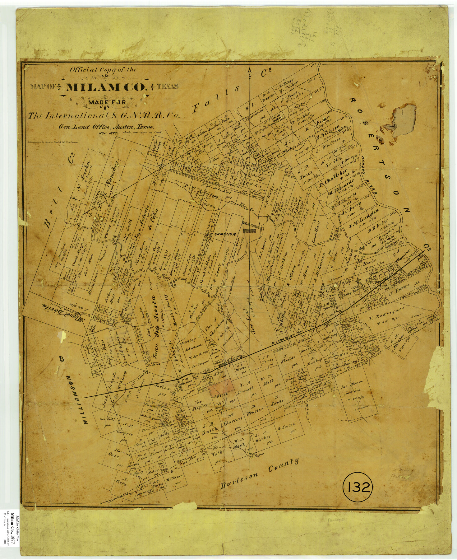
Official Copy of the Map of Milam County made for the International and G. N. R. R. Co.
-
Map/Doc
581
-
Collection
Maddox Collection
-
Object Dates
1877 (Creation Date)
-
People and Organizations
General Land Office (Publisher)
August Gast & Co. (Lithographer)
-
Counties
Milam
-
Subjects
County
-
Height x Width
23.9 x 22.5 inches
60.7 x 57.2 cm
-
Medium
paper, etching/engraving/lithograph
-
Scale
1:4000
-
Comments
Conservation funded in 2004 with donation from Mr. and Mrs. Casey McManemin in memory of John Harlan
-
Features
Sandy Creek
1st Yegua [Creek]
Davidson's Creek
Brushy Creek
Spring Creek
Milano St[atio]n
Rockdale St[atio]n
Alligator Creek
San Gabriel River
Pond Creek
Gause St[atio]n
Clay's Creek
Donahoe's Creek
Cameron
Elm Creek
Jones Creek
Brazos River
Part of: Maddox Collection
Marion County, Texas

Print $20.00
- Digital $50.00
Marion County, Texas
1879
Size 15.0 x 20.7 inches
Map/Doc 651
Map of Lands Belonging to the Austin & Northern Land & Cattle Co., Coke Co., Texas

Print $20.00
- Digital $50.00
Map of Lands Belonging to the Austin & Northern Land & Cattle Co., Coke Co., Texas
Size 23.5 x 19.0 inches
Map/Doc 379
Official Copy of the Map of Milam County made for the International and G. N. R. R. Co.

Print $20.00
- Digital $50.00
Official Copy of the Map of Milam County made for the International and G. N. R. R. Co.
1877
Size 23.9 x 22.5 inches
Map/Doc 581
Sketch of Garza Co.

Print $3.00
- Digital $50.00
Sketch of Garza Co.
1884
Size 12.3 x 10.2 inches
Map/Doc 468
Map of Wood County, Texas

Print $20.00
- Digital $50.00
Map of Wood County, Texas
1879
Size 17.5 x 17.1 inches
Map/Doc 659
Rough sketch showing survey made for L.T. Eck Block 14 and part of Block 13, Fairview Park, South Austin, Texas

Print $2.00
- Digital $50.00
Rough sketch showing survey made for L.T. Eck Block 14 and part of Block 13, Fairview Park, South Austin, Texas
1914
Size 9.0 x 14.4 inches
Map/Doc 467
Midland County, Texas

Print $20.00
- Digital $50.00
Midland County, Texas
1888
Size 22.4 x 17.5 inches
Map/Doc 653
Lubbock County, Texas

Print $20.00
- Digital $50.00
Lubbock County, Texas
1892
Size 27.8 x 22.6 inches
Map/Doc 565
[Sketch of Surveys in Cottle, Dickens, King & Motley Counties, Texas]
![75830, [Sketch of Surveys in Cottle, Dickens, King & Motley Counties, Texas], Maddox Collection](https://historictexasmaps.com/wmedia_w700/maps/75830.tif.jpg)
Print $20.00
- Digital $50.00
[Sketch of Surveys in Cottle, Dickens, King & Motley Counties, Texas]
1913
Size 29.6 x 23.2 inches
Map/Doc 75830
Nolan County, Texas

Print $20.00
- Digital $50.00
Nolan County, Texas
1880
Size 29.5 x 22.7 inches
Map/Doc 588
[Sketch of surveys in Knox County]
![555, [Sketch of surveys in Knox County], Maddox Collection](https://historictexasmaps.com/wmedia_w700/maps/555.tif.jpg)
Print $20.00
- Digital $50.00
[Sketch of surveys in Knox County]
Size 27.1 x 31.1 inches
Map/Doc 555
[Sketch Showing Loma Blanca and San Antonio de Encinal Leagues, Brooks County, Texas]
![4448, [Sketch Showing Loma Blanca and San Antonio de Encinal Leagues, Brooks County, Texas], Maddox Collection](https://historictexasmaps.com/wmedia_w700/maps/4448-1.tif.jpg)
Print $3.00
- Digital $50.00
[Sketch Showing Loma Blanca and San Antonio de Encinal Leagues, Brooks County, Texas]
1912
Size 15.1 x 11.4 inches
Map/Doc 4448
You may also like
General Highway Map, Jim Wells County, Texas

Print $20.00
General Highway Map, Jim Wells County, Texas
1940
Size 18.4 x 24.8 inches
Map/Doc 79148
Amistad International Reservoir on Rio Grande 97

Print $20.00
- Digital $50.00
Amistad International Reservoir on Rio Grande 97
1950
Size 28.5 x 41.1 inches
Map/Doc 75528
Harris County Sketch File 24

Print $8.00
- Digital $50.00
Harris County Sketch File 24
Size 8.8 x 8.0 inches
Map/Doc 25385
Schleicher County Sketch File 34

Print $20.00
- Digital $50.00
Schleicher County Sketch File 34
1949
Size 18.7 x 31.7 inches
Map/Doc 12307
Hudspeth County Working Sketch 40

Print $20.00
- Digital $50.00
Hudspeth County Working Sketch 40
1981
Size 35.6 x 43.8 inches
Map/Doc 66325
McMullen County Rolled Sketch JR

Print $20.00
- Digital $50.00
McMullen County Rolled Sketch JR
Size 29.6 x 29.6 inches
Map/Doc 6737
Dawson County Sketch File 3

Print $20.00
- Digital $50.00
Dawson County Sketch File 3
Size 13.5 x 37.8 inches
Map/Doc 11290
Gillespie County Sketch File 2

Print $40.00
- Digital $50.00
Gillespie County Sketch File 2
1847
Size 12.8 x 15.5 inches
Map/Doc 24127
Mills County Sketch File 9

Print $20.00
- Digital $50.00
Mills County Sketch File 9
Size 36.0 x 29.5 inches
Map/Doc 10544
Goliad County Working Sketch 11

Print $20.00
- Digital $50.00
Goliad County Working Sketch 11
1941
Size 38.8 x 40.8 inches
Map/Doc 63201
Harris County Sketch File 31

Print $6.00
- Digital $50.00
Harris County Sketch File 31
Size 14.0 x 8.9 inches
Map/Doc 25426
Flight Mission No. CRE-2R, Frame 84, Jackson County

Print $20.00
- Digital $50.00
Flight Mission No. CRE-2R, Frame 84, Jackson County
1956
Size 16.1 x 15.9 inches
Map/Doc 85356