Schleicher County Sketch File 34
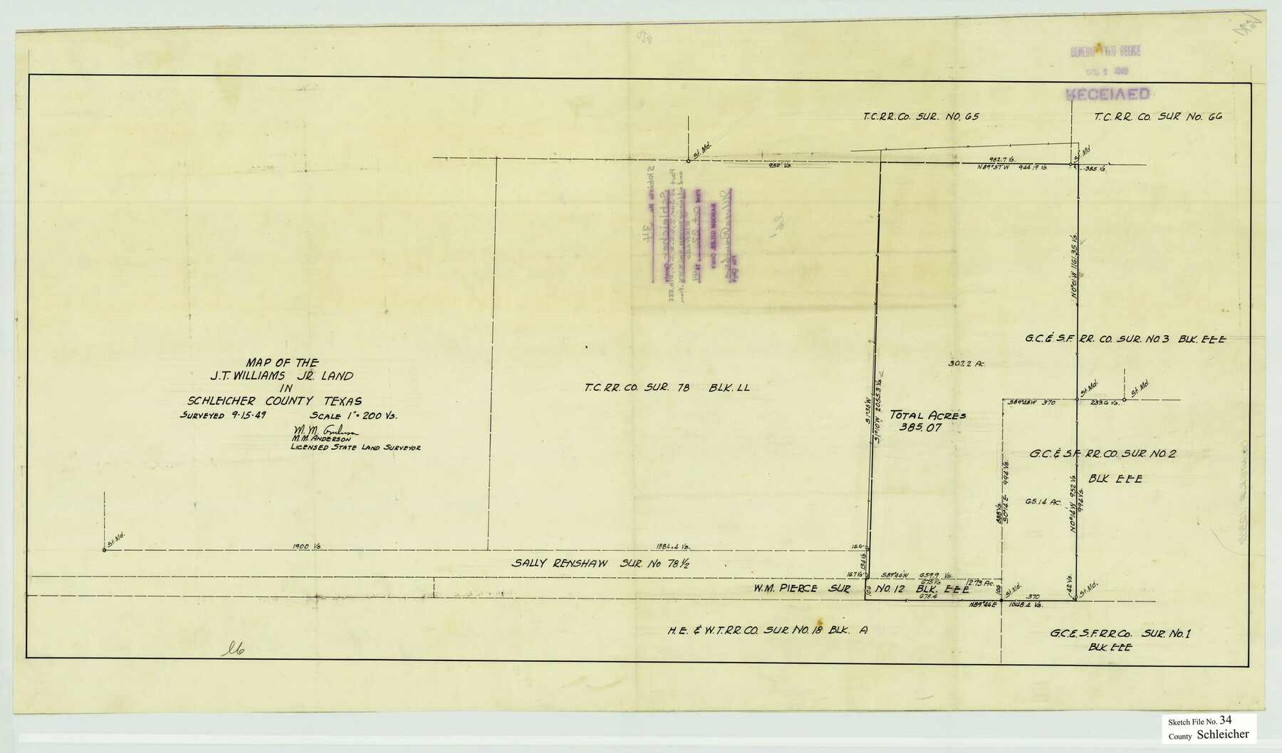
Map of the J.T. Williams, Jr. land in Schleicher County, Texas [consisting of land out of surveys 2 and 3, G. C. & S. F. R.R. Co. Block EEE]
-
Map/Doc
12307
-
Collection
General Map Collection
-
Object Dates
9/15/1949 (Creation Date)
10/22/1949 (File Date)
-
People and Organizations
M.M. Anderson (Surveyor/Engineer)
-
Counties
Schleicher
-
Subjects
Surveying Sketch File
-
Height x Width
18.7 x 31.7 inches
47.5 x 80.5 cm
-
Medium
paper, manuscript
-
Scale
1" = 200 varas
Part of: General Map Collection
McMullen County Rolled Sketch 5

Print $20.00
- Digital $50.00
McMullen County Rolled Sketch 5
Size 46.4 x 26.8 inches
Map/Doc 6723
[Plat of All Surveys on Lavaca Not Heretofor Returned]
![283, [Plat of All Surveys on Lavaca Not Heretofor Returned], General Map Collection](https://historictexasmaps.com/wmedia_w700/maps/283.tif.jpg)
Print $20.00
- Digital $50.00
[Plat of All Surveys on Lavaca Not Heretofor Returned]
1841
Size 31.3 x 22.0 inches
Map/Doc 283
El Paso County Sketch File 7a

Print $4.00
- Digital $50.00
El Paso County Sketch File 7a
Size 8.5 x 4.1 inches
Map/Doc 22002
Aransas Pass to Baffin Bay

Print $40.00
- Digital $50.00
Aransas Pass to Baffin Bay
1988
Size 48.7 x 36.0 inches
Map/Doc 73422
Lavaca County Working Sketch 9

Print $20.00
- Digital $50.00
Lavaca County Working Sketch 9
1949
Size 24.7 x 33.9 inches
Map/Doc 70362
Flight Mission No. DQO-8K, Frame 48, Galveston County

Print $20.00
- Digital $50.00
Flight Mission No. DQO-8K, Frame 48, Galveston County
1952
Size 18.7 x 22.2 inches
Map/Doc 85155
Lavaca County Working Sketch 12

Print $20.00
- Digital $50.00
Lavaca County Working Sketch 12
1954
Size 17.3 x 32.4 inches
Map/Doc 70365
Erath County Sketch File A1

Print $6.00
- Digital $50.00
Erath County Sketch File A1
Size 10.6 x 11.8 inches
Map/Doc 22251
Nueces County Rolled Sketch 105

Print $96.00
Nueces County Rolled Sketch 105
1986
Size 18.1 x 25.4 inches
Map/Doc 7086
Pecos County Sketch File 65

Print $6.00
- Digital $50.00
Pecos County Sketch File 65
1919
Size 16.7 x 11.9 inches
Map/Doc 33824
Pecos County Working Sketch 131

Print $20.00
- Digital $50.00
Pecos County Working Sketch 131
1977
Size 27.8 x 21.1 inches
Map/Doc 71605
Political Essay on the Kingdom of New Spain Vol. 1, Third Edition

Political Essay on the Kingdom of New Spain Vol. 1, Third Edition
1822
Map/Doc 97386
You may also like
Midland County Working Sketch 10

Print $20.00
- Digital $50.00
Midland County Working Sketch 10
1951
Size 30.2 x 21.2 inches
Map/Doc 70990
Robertson County Working Sketch 17

Print $20.00
- Digital $50.00
Robertson County Working Sketch 17
1991
Size 16.8 x 22.9 inches
Map/Doc 63590
Uvalde County Working Sketch 61

Print $20.00
- Digital $50.00
Uvalde County Working Sketch 61
1978
Size 40.4 x 37.4 inches
Map/Doc 72131
Intracoastal Waterway - Laguna Madre - Rincon de San Jose to Chubby Island, Texas

Print $20.00
- Digital $50.00
Intracoastal Waterway - Laguna Madre - Rincon de San Jose to Chubby Island, Texas
1975
Size 16.0 x 37.1 inches
Map/Doc 73516
Flight Mission No. BRA-16M, Frame 87, Jefferson County

Print $20.00
- Digital $50.00
Flight Mission No. BRA-16M, Frame 87, Jefferson County
1953
Size 18.6 x 22.3 inches
Map/Doc 85699
General Highway Map. Detail of Cities and Towns in Harris County, Texas

Print $20.00
General Highway Map. Detail of Cities and Towns in Harris County, Texas
1939
Size 18.2 x 24.9 inches
Map/Doc 79119
Flight Mission No. CUG-1P, Frame 70, Kleberg County

Print $20.00
- Digital $50.00
Flight Mission No. CUG-1P, Frame 70, Kleberg County
1956
Size 18.5 x 22.3 inches
Map/Doc 86135

Presidio County Working Sketch 60

Print $20.00
- Digital $50.00
Presidio County Working Sketch 60
1957
Size 21.9 x 18.4 inches
Map/Doc 71737
Crosby County Sketch File 1b

Print $20.00
- Digital $50.00
Crosby County Sketch File 1b
Size 18.0 x 14.5 inches
Map/Doc 11244
Wise County Sketch File 26

Print $22.00
- Digital $50.00
Wise County Sketch File 26
1855
Size 8.1 x 14.3 inches
Map/Doc 40574
Ward County Rolled Sketch 24D

Print $40.00
- Digital $50.00
Ward County Rolled Sketch 24D
Size 45.6 x 69.0 inches
Map/Doc 10113