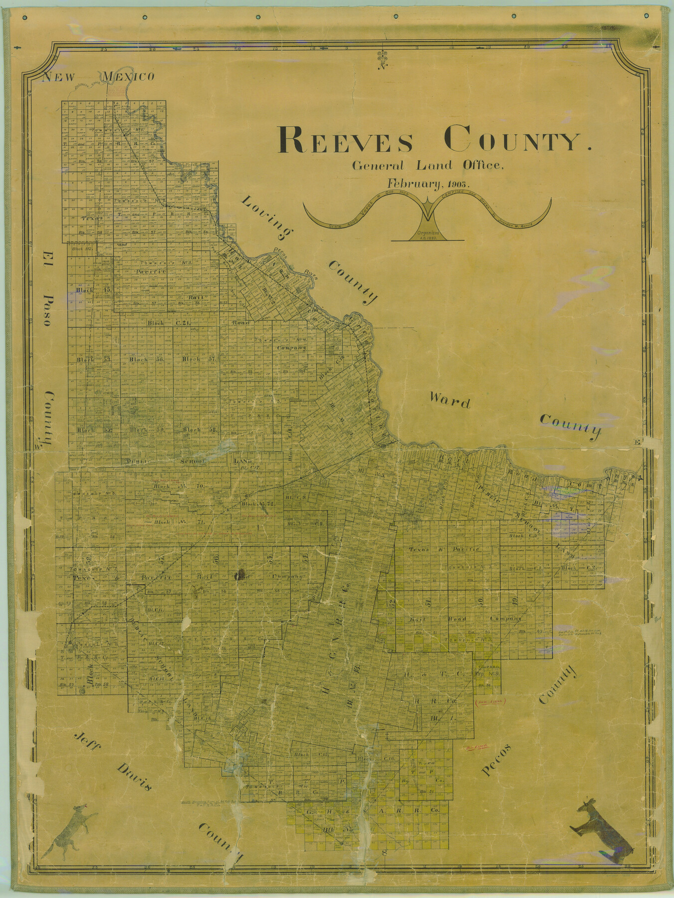
Reeves County
-
Map/Doc
16798
-
Collection
General Map Collection
-
Object Dates
1903 (Creation Date)
-
People and Organizations
Texas General Land Office (Publisher)
Jourdan W. Morris (Compiler)
Jourdan W. Morris (Draftsman)
-
Counties
Reeves
-
Subjects
County
-
Height x Width
48.7 x 36.5 inches
123.7 x 92.7 cm
-
Comments
Help Save Texas History - Adopt Me!
-
Features
Toyah
Hermoso
Gomez
Barillo Spring
Carrizo Spring
Barillo Cañon
Phantom Lake
Gomez Peak
San Martine Mountain
San Martine Spring
San Martine
T&P
Delaware Creek
Toyah Lake
Great Falls
Brant
Lucerne
Pecos City
Lomena
Pecos River
Hagertown
PVRR
Murray
Part of: General Map Collection
Limestone County Working Sketch 20

Print $20.00
- Digital $50.00
Limestone County Working Sketch 20
1976
Size 41.5 x 42.3 inches
Map/Doc 70570
[Surveys on the San Marcos River]
![149, [Surveys on the San Marcos River], General Map Collection](https://historictexasmaps.com/wmedia_w700/maps/149.tif.jpg)
Print $20.00
- Digital $50.00
[Surveys on the San Marcos River]
Size 14.1 x 12.4 inches
Map/Doc 149
Greer County Sketch File 5

Print $8.00
- Digital $50.00
Greer County Sketch File 5
1883
Size 10.0 x 15.6 inches
Map/Doc 24521
Pecos County Working Sketch 81

Print $40.00
- Digital $50.00
Pecos County Working Sketch 81
1961
Size 35.4 x 49.7 inches
Map/Doc 71553
Jackson County Working Sketch 14

Print $20.00
- Digital $50.00
Jackson County Working Sketch 14
1990
Size 31.7 x 32.2 inches
Map/Doc 66462

Flight Mission No. DIX-8P, Frame 67, Aransas County

Print $20.00
- Digital $50.00
Flight Mission No. DIX-8P, Frame 67, Aransas County
1956
Size 18.7 x 22.4 inches
Map/Doc 83898
Yoakum County Working Sketch Graphic Index

Print $20.00
- Digital $50.00
Yoakum County Working Sketch Graphic Index
1932
Size 44.7 x 33.1 inches
Map/Doc 76747
South Part of Brewster Co.

Print $40.00
- Digital $50.00
South Part of Brewster Co.
1955
Size 49.3 x 41.3 inches
Map/Doc 66735
Red River County Sketch File 24

Print $6.00
- Digital $50.00
Red River County Sketch File 24
1920
Size 11.4 x 8.8 inches
Map/Doc 35158
Wheeler County Sketch File 3

Print $24.00
- Digital $50.00
Wheeler County Sketch File 3
1881
Size 12.9 x 8.4 inches
Map/Doc 39998
Connected Map of Austin's Colony

Print $40.00
- Digital $50.00
Connected Map of Austin's Colony
1837
Size 93.2 x 43.7 inches
Map/Doc 93377
You may also like
Lines of Equal Magnetic Declination and of Equal Annual Change in the United States for 1930

Print $20.00
- Digital $50.00
Lines of Equal Magnetic Declination and of Equal Annual Change in the United States for 1930
1930
Size 23.5 x 29.7 inches
Map/Doc 69652
El Paso County Rolled Sketch 42

Print $20.00
- Digital $50.00
El Paso County Rolled Sketch 42
Size 34.5 x 24.5 inches
Map/Doc 5828
El Paso County Rolled Sketch EC

Print $20.00
- Digital $50.00
El Paso County Rolled Sketch EC
1912
Size 30.1 x 18.2 inches
Map/Doc 5857
Palo Pinto County Boundary File 1

Print $4.00
- Digital $50.00
Palo Pinto County Boundary File 1
Size 12.8 x 8.4 inches
Map/Doc 57789
Northern Mexico Campaign of the U.S. - Mexico War

Northern Mexico Campaign of the U.S. - Mexico War
2023
Size 8.5 x 11.0 inches
Map/Doc 97152
Events of the Texas Revolution

Events of the Texas Revolution
2023
Size 11.0 x 8.5 inches
Map/Doc 97189
Pecos County Sketch File 39

Print $20.00
- Digital $50.00
Pecos County Sketch File 39
1898
Size 17.5 x 16.5 inches
Map/Doc 12177
Pecos County Working Sketch 114

Print $40.00
- Digital $50.00
Pecos County Working Sketch 114
1972
Size 75.7 x 38.0 inches
Map/Doc 71587
Webb County Sketch File 1-2

Print $20.00
- Digital $50.00
Webb County Sketch File 1-2
1912
Size 21.2 x 22.6 inches
Map/Doc 12611
Schleicher County Working Sketch 12

Print $20.00
- Digital $50.00
Schleicher County Working Sketch 12
1925
Size 23.7 x 22.2 inches
Map/Doc 63814
Die Vereinigten Staaten v. Nord-America

Print $20.00
- Digital $50.00
Die Vereinigten Staaten v. Nord-America
1846
Size 21.0 x 27.9 inches
Map/Doc 94513
Tom Green County Working Sketch 1

Print $3.00
- Digital $50.00
Tom Green County Working Sketch 1
1915
Size 11.0 x 13.8 inches
Map/Doc 69370