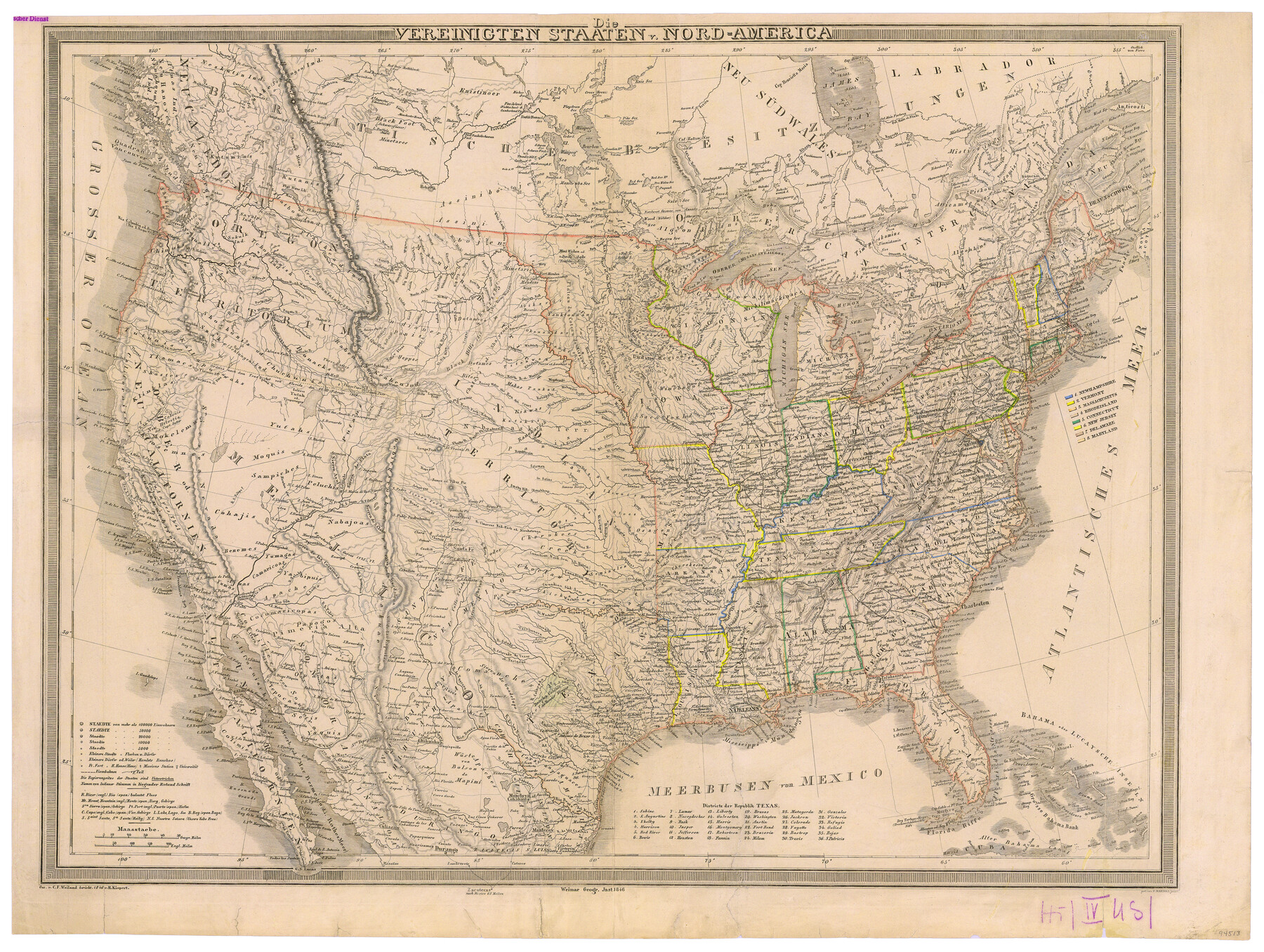
Die Vereinigten Staaten v. Nord-America
-
Map/Doc
94513
-
Collection
General Map Collection
-
Object Dates
1846 (Creation Date)
-
People and Organizations
Geographisches Institut (Publisher)
J. Maedel Jr. (Printer)
C.F. Weiland (Cartographer)
H. Kiepert (Cartographer)
-
Subjects
Republic of Texas United States
-
Height x Width
21.0 x 27.9 inches
53.3 x 70.9 cm
-
Medium
paper, etching/engraving/lithograph
Part of: General Map Collection
[Surveys between the Sabine and Red Rivers made for titles under Radford Berry, Commissioner]
![14, [Surveys between the Sabine and Red Rivers made for titles under Radford Berry, Commissioner], General Map Collection](https://historictexasmaps.com/wmedia_w700/maps/14.tif.jpg)
Print $20.00
- Digital $50.00
[Surveys between the Sabine and Red Rivers made for titles under Radford Berry, Commissioner]
1835
Size 22.3 x 15.9 inches
Map/Doc 14
Flight Mission No. CGI-3N, Frame 104, Cameron County

Print $20.00
- Digital $50.00
Flight Mission No. CGI-3N, Frame 104, Cameron County
1954
Size 18.6 x 22.3 inches
Map/Doc 84584
[Sketch for Mineral Application 26501 - Sabine River, T. A. Oldhausen]
![2842, [Sketch for Mineral Application 26501 - Sabine River, T. A. Oldhausen], General Map Collection](https://historictexasmaps.com/wmedia_w700/maps/2842.tif.jpg)
Print $20.00
- Digital $50.00
[Sketch for Mineral Application 26501 - Sabine River, T. A. Oldhausen]
1931
Size 24.0 x 36.9 inches
Map/Doc 2842
Flight Mission No. DQN-1K, Frame 28, Calhoun County

Print $20.00
- Digital $50.00
Flight Mission No. DQN-1K, Frame 28, Calhoun County
1953
Size 18.5 x 22.3 inches
Map/Doc 84133
Rio Grande - Rio Grande Sheet

Print $40.00
- Digital $50.00
Rio Grande - Rio Grande Sheet
1929
Size 53.9 x 27.3 inches
Map/Doc 65105
East Part of Jeff Davis Co.

Print $20.00
- Digital $50.00
East Part of Jeff Davis Co.
1977
Size 47.9 x 36.9 inches
Map/Doc 95544
Hardin County Sketch File 56

Print $10.00
- Digital $50.00
Hardin County Sketch File 56
Size 11.2 x 8.7 inches
Map/Doc 25221
Loving County Rolled Sketch 3

Print $40.00
- Digital $50.00
Loving County Rolled Sketch 3
1952
Size 13.7 x 145.1 inches
Map/Doc 78185
Childress County Working Sketch Graphic Index

Print $20.00
- Digital $50.00
Childress County Working Sketch Graphic Index
1978
Size 45.5 x 34.3 inches
Map/Doc 76493
Johnson County Rolled Sketch 4

Print $20.00
- Digital $50.00
Johnson County Rolled Sketch 4
Size 24.8 x 36.0 inches
Map/Doc 94047
Map of the Surveyed Part of Young District

Print $40.00
- Digital $50.00
Map of the Surveyed Part of Young District
1860
Size 56.3 x 32.6 inches
Map/Doc 87373
Blanco County Rolled Sketch 5

Print $20.00
- Digital $50.00
Blanco County Rolled Sketch 5
Size 15.6 x 17.0 inches
Map/Doc 5143
You may also like
Hardin County Rolled Sketch 16

Print $39.00
- Digital $50.00
Hardin County Rolled Sketch 16
1940
Size 9.9 x 15.9 inches
Map/Doc 45750
Briscoe County Sketch File N

Print $40.00
- Digital $50.00
Briscoe County Sketch File N
Size 26.0 x 21.9 inches
Map/Doc 11012
Block A; Melvin, Blum and Blum, Bailey County, Texas

Print $20.00
- Digital $50.00
Block A; Melvin, Blum and Blum, Bailey County, Texas
Size 23.8 x 19.5 inches
Map/Doc 92539

King County Survey made by A.C. Tackitt and W.D. Twichell

Print $20.00
- Digital $50.00
King County Survey made by A.C. Tackitt and W.D. Twichell
1916
Size 27.5 x 25.1 inches
Map/Doc 5069
Houston, Capital of Texas, 1837

Print $21.65
Houston, Capital of Texas, 1837
2007
Size 17.4 x 24.3 inches
Map/Doc 89272
Childress County Rolled Sketch 18

Print $20.00
- Digital $50.00
Childress County Rolled Sketch 18
1913
Size 17.6 x 39.0 inches
Map/Doc 5451
State of Texas

Print $40.00
- Digital $50.00
State of Texas
1985
Size 50.0 x 53.6 inches
Map/Doc 2486

Brazoria County Rolled Sketch 18B

Print $20.00
- Digital $50.00
Brazoria County Rolled Sketch 18B
1914
Size 10.0 x 17.3 inches
Map/Doc 5165
Pecos County Rolled Sketch 59

Print $20.00
- Digital $50.00
Pecos County Rolled Sketch 59
1922
Size 16.6 x 17.0 inches
Map/Doc 7231
Jeff Davis County Working Sketch Graphic Index - central part

Print $40.00
- Digital $50.00
Jeff Davis County Working Sketch Graphic Index - central part
1982
Size 55.7 x 42.6 inches
Map/Doc 76593