Webb County Sketch File 1-2
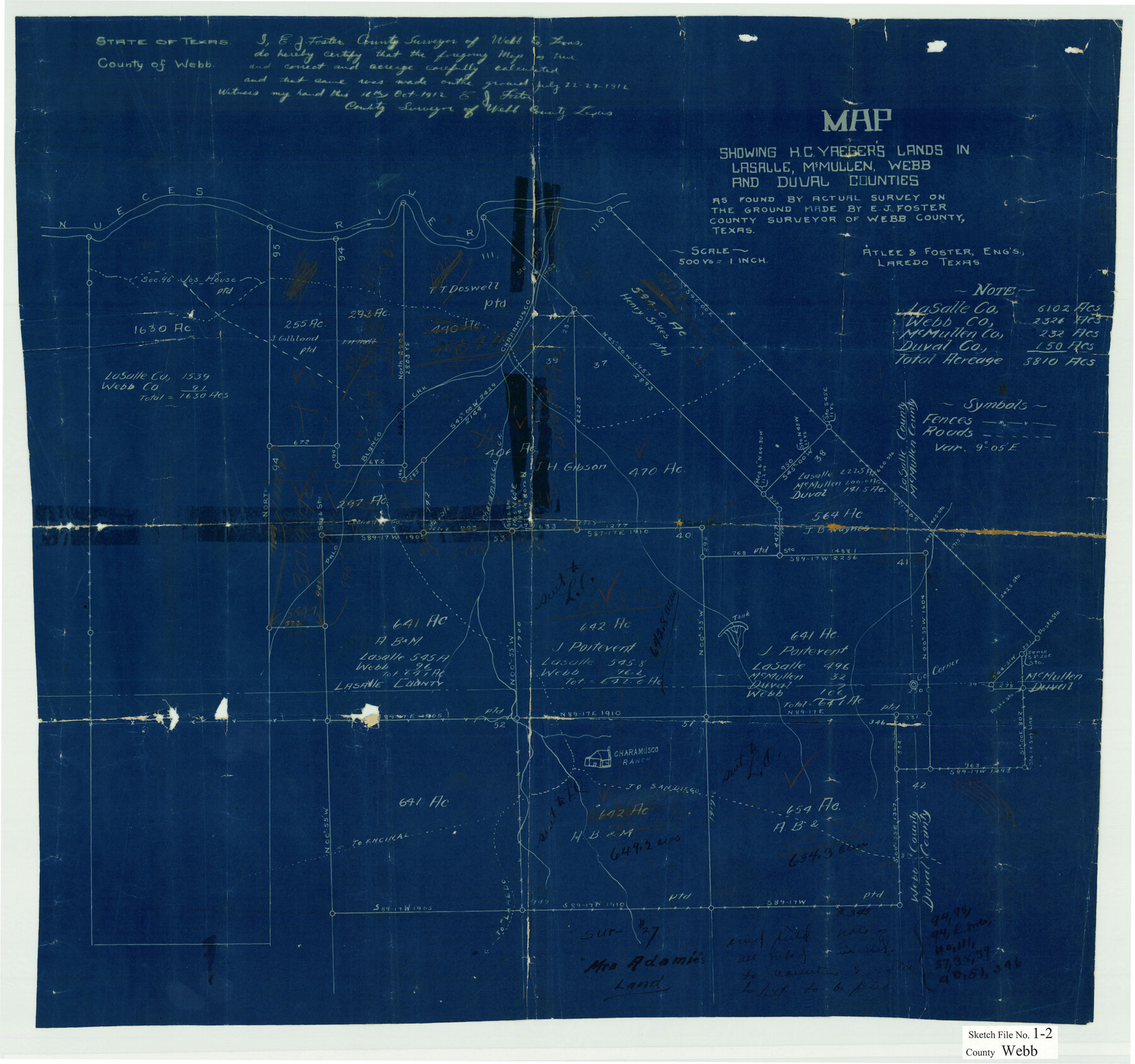
Map showing H.C. Yaeger's lands in La Salle, McMullen, Webb, and Duval Counties as found by actual survey on the ground made by E.J. Foster, County Surveyor of Webb County, Texas
-
Map/Doc
12611
-
Collection
General Map Collection
-
Object Dates
10/16/1912 (Creation Date)
7/22-27/1912 (Survey Date)
-
People and Organizations
E.J. Foster (Surveyor/Engineer)
-
Counties
Webb La Salle McMullen Duval
-
Subjects
Surveying Sketch File
-
Height x Width
21.2 x 22.6 inches
53.9 x 57.4 cm
-
Medium
blueprint/diazo
-
Scale
1" = 500 varas
-
Features
Nueces River
Charamusco Creek
Palo Blanco Creek
Road to San Diego
Charamusco Ranch
Road to Encinal
Road to Laredo
Part of: General Map Collection
Polk County Working Sketch 31

Print $20.00
- Digital $50.00
Polk County Working Sketch 31
1960
Size 18.2 x 24.4 inches
Map/Doc 71647
La Salle County Sketch File 4

Print $22.00
- Digital $50.00
La Salle County Sketch File 4
Size 12.7 x 16.2 inches
Map/Doc 29450
Martin County Working Sketch 9

Print $20.00
- Digital $50.00
Martin County Working Sketch 9
1971
Size 45.2 x 38.1 inches
Map/Doc 70827
Colorado County Working Sketch 30

Print $20.00
- Digital $50.00
Colorado County Working Sketch 30
1980
Size 22.2 x 19.8 inches
Map/Doc 68130
Live Oak County Working Sketch 29

Print $20.00
- Digital $50.00
Live Oak County Working Sketch 29
1983
Size 33.7 x 42.8 inches
Map/Doc 70614
Jasper County Working Sketch 2

Print $20.00
- Digital $50.00
Jasper County Working Sketch 2
Size 18.6 x 22.5 inches
Map/Doc 66464
Spanish land grants (other than porciones) in the trans-Nueces

Spanish land grants (other than porciones) in the trans-Nueces
2009
Size 11.0 x 8.5 inches
Map/Doc 94046
Flight Mission No. DQN-1K, Frame 103, Calhoun County

Print $20.00
- Digital $50.00
Flight Mission No. DQN-1K, Frame 103, Calhoun County
1953
Size 18.5 x 22.1 inches
Map/Doc 84170
Leon County Sketch File 25

Print $26.00
- Digital $50.00
Leon County Sketch File 25
Size 11.3 x 8.5 inches
Map/Doc 29788
Anderson County Working Sketch 41

Print $20.00
- Digital $50.00
Anderson County Working Sketch 41
1956
Size 19.2 x 20.5 inches
Map/Doc 67041
Travis County Boundary File 32

Print $5.00
- Digital $50.00
Travis County Boundary File 32
Size 11.8 x 9.4 inches
Map/Doc 59473
United States - Gulf Coast - Galveston to Rio Grande

Print $20.00
- Digital $50.00
United States - Gulf Coast - Galveston to Rio Grande
1940
Size 27.4 x 18.3 inches
Map/Doc 72757
You may also like
Map of Webb Co.

Print $20.00
- Digital $50.00
Map of Webb Co.
1901
Size 40.4 x 47.1 inches
Map/Doc 16919
Subdivision Map of Childress County School Land Situated in Bailey and Cochran Counties, Texas

Print $20.00
- Digital $50.00
Subdivision Map of Childress County School Land Situated in Bailey and Cochran Counties, Texas
Size 23.0 x 26.4 inches
Map/Doc 92526
Flight Mission No. CUG-2P, Frame 59, Kleberg County

Print $20.00
- Digital $50.00
Flight Mission No. CUG-2P, Frame 59, Kleberg County
1956
Size 18.4 x 22.1 inches
Map/Doc 86196
Atascosa County Working Sketch Graphic Index

Print $20.00
- Digital $50.00
Atascosa County Working Sketch Graphic Index
1948
Size 46.1 x 42.8 inches
Map/Doc 76458
Cherokee County Working Sketch 8

Print $20.00
- Digital $50.00
Cherokee County Working Sketch 8
1956
Size 22.0 x 45.2 inches
Map/Doc 67963
Galveston County NRC Article 33.136 Sketch 64

Print $26.00
- Digital $50.00
Galveston County NRC Article 33.136 Sketch 64
2010
Size 24.0 x 36.0 inches
Map/Doc 89990
Ochiltree County Working Sketch 6

Print $20.00
- Digital $50.00
Ochiltree County Working Sketch 6
1962
Size 31.1 x 22.9 inches
Map/Doc 71319
Big Inch and Little Big Inch Pipelines

Big Inch and Little Big Inch Pipelines
2022
Size 8.5 x 11.0 inches
Map/Doc 97089
Wood County Sketch File 13

Print $24.00
- Digital $50.00
Wood County Sketch File 13
1866
Size 12.5 x 7.6 inches
Map/Doc 40668
United States - Gulf Coast Texas - Southern part of Laguna Madre

Print $20.00
- Digital $50.00
United States - Gulf Coast Texas - Southern part of Laguna Madre
1933
Size 26.9 x 18.3 inches
Map/Doc 72952
Flight Mission No. CRE-3R, Frame 39, Jackson County

Print $20.00
- Digital $50.00
Flight Mission No. CRE-3R, Frame 39, Jackson County
1956
Size 18.6 x 22.2 inches
Map/Doc 85386
Red River County Sketch File 25

Print $20.00
- Digital $50.00
Red River County Sketch File 25
Size 26.0 x 38.9 inches
Map/Doc 10586