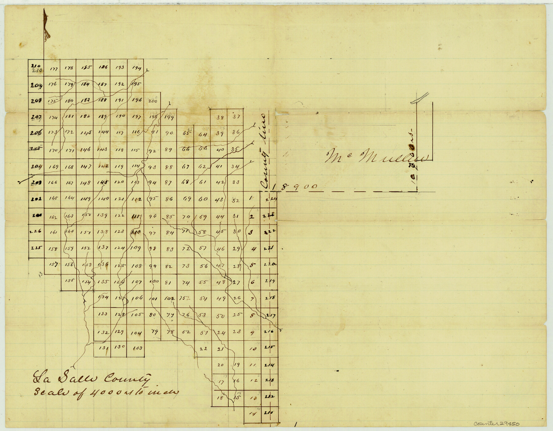
La Salle County Sketch File 4
[Sketch on La Salle-McMullen County line]
-
Map/Doc
29450
-
Collection
General Map Collection
-
Object Dates
1875/7/6 (File Date)
-
Counties
La Salle McMullen
-
Subjects
Surveying Sketch File
-
Height x Width
12.7 x 16.2 inches
32.3 x 41.2 cm
-
Medium
paper, manuscript
-
Scale
1:4000
Part of: General Map Collection
Aransas County Working Sketch 4

Print $20.00
- Digital $50.00
Aransas County Working Sketch 4
1928
Size 37.4 x 31.8 inches
Map/Doc 67171
McLennan County Sketch File 7b

Print $6.00
- Digital $50.00
McLennan County Sketch File 7b
1857
Size 8.0 x 10.1 inches
Map/Doc 31248
Flight Mission No. DQN-2K, Frame 9, Calhoun County

Print $20.00
- Digital $50.00
Flight Mission No. DQN-2K, Frame 9, Calhoun County
1953
Size 15.7 x 15.6 inches
Map/Doc 84226
Maps of Gulf Intracoastal Waterway, Texas - Sabine River to the Rio Grande and connecting waterways including ship channels

Print $20.00
- Digital $50.00
Maps of Gulf Intracoastal Waterway, Texas - Sabine River to the Rio Grande and connecting waterways including ship channels
1966
Size 14.6 x 22.3 inches
Map/Doc 61959
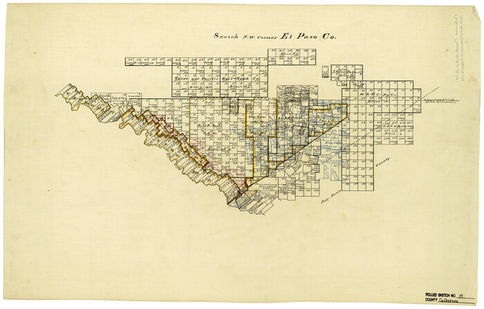
Culberson County Rolled Sketch 19
Print $20.00
- Digital $50.00
Culberson County Rolled Sketch 19
Size 18.8 x 29.4 inches
Map/Doc 5651
Brewster County Rolled Sketch 114

Print $20.00
- Digital $50.00
Brewster County Rolled Sketch 114
1964
Size 11.7 x 17.9 inches
Map/Doc 5288
Reeves County

Print $20.00
- Digital $50.00
Reeves County
1915
Size 46.5 x 35.7 inches
Map/Doc 16797
Flight Mission No. DIX-7P, Frame 22, Aransas County

Print $20.00
- Digital $50.00
Flight Mission No. DIX-7P, Frame 22, Aransas County
1956
Size 18.7 x 22.5 inches
Map/Doc 83874
Jefferson County Sketch File 56

Print $34.00
- Digital $50.00
Jefferson County Sketch File 56
2007
Map/Doc 93427
Hopkins County Boundary File 3a

Print $4.00
- Digital $50.00
Hopkins County Boundary File 3a
Size 10.7 x 8.7 inches
Map/Doc 55082
Duval County Working Sketch 24

Print $20.00
- Digital $50.00
Duval County Working Sketch 24
1944
Size 40.0 x 27.3 inches
Map/Doc 68748
Fannin County Boundary File 10a and 10b and 10c

Print $2.00
- Digital $50.00
Fannin County Boundary File 10a and 10b and 10c
Size 11.2 x 9.1 inches
Map/Doc 53327
You may also like
[Bastrop District]
![83518, [Bastrop District], General Map Collection](https://historictexasmaps.com/wmedia_w700/maps/83518-1.tif.jpg)
Print $20.00
- Digital $50.00
[Bastrop District]
1838
Size 19.5 x 44.2 inches
Map/Doc 83518
Fisher County Working Sketch 4

Print $20.00
- Digital $50.00
Fisher County Working Sketch 4
1926
Size 24.4 x 17.2 inches
Map/Doc 69138
Parker County Rolled Sketch 3

Print $20.00
- Digital $50.00
Parker County Rolled Sketch 3
1975
Size 22.7 x 18.3 inches
Map/Doc 7204
The Chief Justice County of Matagorda. Lands in Conflict with Brazoria County

Print $20.00
The Chief Justice County of Matagorda. Lands in Conflict with Brazoria County
2020
Size 19.7 x 21.7 inches
Map/Doc 96058
Coryell County Working Sketch 13

Print $20.00
- Digital $50.00
Coryell County Working Sketch 13
1950
Size 20.9 x 22.7 inches
Map/Doc 68220
Flight Mission No. CRE-1R, Frame 125, Jackson County

Print $20.00
- Digital $50.00
Flight Mission No. CRE-1R, Frame 125, Jackson County
1956
Size 17.5 x 22.3 inches
Map/Doc 85336
Brewster County Rolled Sketch 22A

Print $20.00
- Digital $50.00
Brewster County Rolled Sketch 22A
1910
Size 33.0 x 24.8 inches
Map/Doc 5202
Panola County Rolled Sketch 4A

Print $40.00
- Digital $50.00
Panola County Rolled Sketch 4A
1953
Size 50.7 x 26.1 inches
Map/Doc 10727
King County Sketch File 5

Print $6.00
- Digital $50.00
King County Sketch File 5
1895
Size 10.6 x 12.2 inches
Map/Doc 29024
Crosby County Sketch File 26

Print $28.00
- Digital $50.00
Crosby County Sketch File 26
1888
Size 14.1 x 8.6 inches
Map/Doc 20098
Jackson County Sketch File 29

Print $10.00
- Digital $50.00
Jackson County Sketch File 29
Size 13.4 x 8.7 inches
Map/Doc 27725
Stonewall County Sketch File 24

Print $6.00
- Digital $50.00
Stonewall County Sketch File 24
1951
Size 24.8 x 35.2 inches
Map/Doc 12369