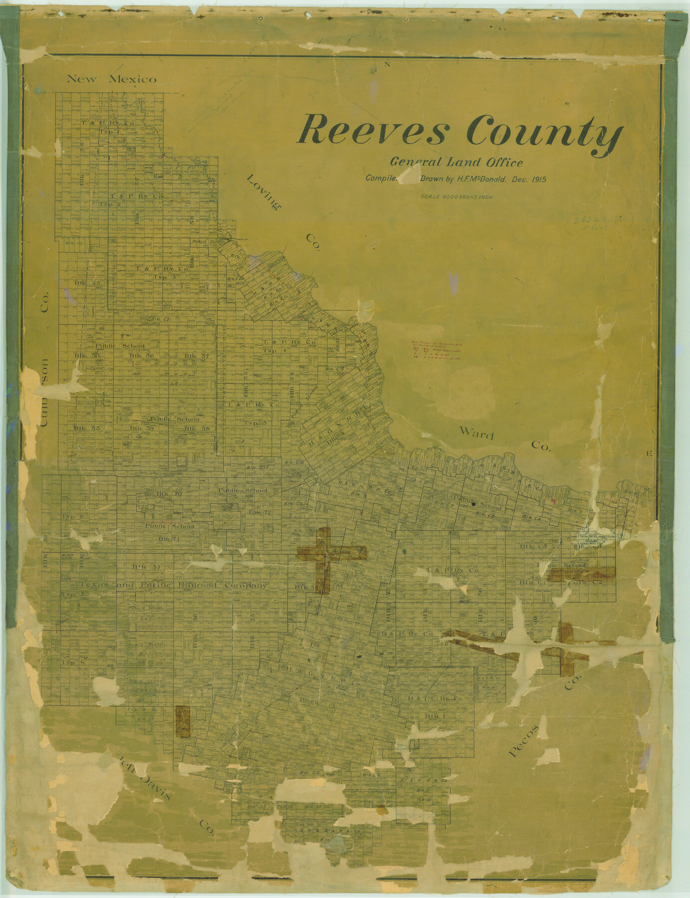
Reeves County
-
Map/Doc
16797
-
Collection
General Map Collection
-
Object Dates
1915/12/8 (Creation Date)
-
People and Organizations
Texas General Land Office (Publisher)
H.F. McDonald (Draftsman)
H.F. McDonald (Compiler)
-
Counties
Reeves
-
Subjects
County
-
Height x Width
46.5 x 35.7 inches
118.1 x 90.7 cm
-
Comments
Help Save Texas History - Adopt Me!
-
Features
Verhale
Sargent
PR
Riverton
Murray
Lucerne
Toyahville
Balmorhea
Toyah Creek
Saragosa
Hagertown
San Martine
Gomez
Toyah Lake
Sisk
Toyah
T&P
Hermosa
Pecos City
Pecos River
Part of: General Map Collection
Reeves County Rolled Sketch N

Print $40.00
- Digital $50.00
Reeves County Rolled Sketch N
Size 44.5 x 74.7 inches
Map/Doc 9846
Pecos County Sketch File 31

Print $20.00
- Digital $50.00
Pecos County Sketch File 31
1931
Size 14.3 x 32.4 inches
Map/Doc 12173
Washington County Working Sketch 3

Print $20.00
- Digital $50.00
Washington County Working Sketch 3
1992
Size 31.5 x 42.7 inches
Map/Doc 72364
Loving County Working Sketch 14

Print $40.00
- Digital $50.00
Loving County Working Sketch 14
1957
Size 86.7 x 35.0 inches
Map/Doc 70647
Caldwell County Sketch File 5

Print $8.00
- Digital $50.00
Caldwell County Sketch File 5
Size 14.1 x 8.6 inches
Map/Doc 35843
Nueces County Rolled Sketch 77

Print $55.00
Nueces County Rolled Sketch 77
1982
Size 24.6 x 36.3 inches
Map/Doc 6938
Hall County Sketch File C1

Print $24.00
- Digital $50.00
Hall County Sketch File C1
1912
Size 8.3 x 5.3 inches
Map/Doc 24787
Travis County Rolled Sketch 61

Print $20.00
- Digital $50.00
Travis County Rolled Sketch 61
2023
Size 36.0 x 24.0 inches
Map/Doc 97184
Flight Mission No. CRC-2R, Frame 3, Chambers County

Print $20.00
- Digital $50.00
Flight Mission No. CRC-2R, Frame 3, Chambers County
1956
Size 18.8 x 22.5 inches
Map/Doc 84722
Eastland County Rolled Sketch 3

Print $20.00
- Digital $50.00
Eastland County Rolled Sketch 3
1893
Size 24.4 x 41.3 inches
Map/Doc 5773
Culberson County Working Sketch 56

Print $20.00
- Digital $50.00
Culberson County Working Sketch 56
1974
Size 38.7 x 32.1 inches
Map/Doc 68510
Flight Mission No. BRE-2P, Frame 34, Nueces County

Print $20.00
- Digital $50.00
Flight Mission No. BRE-2P, Frame 34, Nueces County
1956
Size 18.7 x 22.6 inches
Map/Doc 86736
You may also like
Bray Subdivision and McElroy Subdivision

Print $20.00
- Digital $50.00
Bray Subdivision and McElroy Subdivision
Size 19.3 x 25.2 inches
Map/Doc 92746
Yoakum County Sketch File 8

Print $20.00
- Digital $50.00
Yoakum County Sketch File 8
Size 25.6 x 29.3 inches
Map/Doc 12705
Working Sketch Patents & Field Notes, Sabine Lake Area

Print $20.00
- Digital $50.00
Working Sketch Patents & Field Notes, Sabine Lake Area
1959
Size 30.2 x 27.0 inches
Map/Doc 2455
Erforschung von Nordwest-Texas

Print $20.00
- Digital $50.00
Erforschung von Nordwest-Texas
1873
Size 11.4 x 9.4 inches
Map/Doc 95144
Haskell County Working Sketch 3

Print $20.00
- Digital $50.00
Haskell County Working Sketch 3
1920
Size 41.4 x 21.9 inches
Map/Doc 66061
Hudspeth County Working Sketch 11

Print $20.00
- Digital $50.00
Hudspeth County Working Sketch 11
1946
Size 32.1 x 36.2 inches
Map/Doc 66292
Dallas County Sketch File 9

Print $4.00
- Digital $50.00
Dallas County Sketch File 9
1858
Size 12.2 x 8.1 inches
Map/Doc 20412
Kimble County Working Sketch 47

Print $20.00
- Digital $50.00
Kimble County Working Sketch 47
1951
Size 42.9 x 24.3 inches
Map/Doc 70115
Crockett County Rolled Sketch 92

Print $20.00
- Digital $50.00
Crockett County Rolled Sketch 92
1977
Size 43.0 x 25.2 inches
Map/Doc 5632
Red River County, Texas

Print $20.00
- Digital $50.00
Red River County, Texas
1879
Size 29.3 x 21.9 inches
Map/Doc 598
Young County Rolled Sketch 12

Print $20.00
- Digital $50.00
Young County Rolled Sketch 12
Size 24.2 x 17.9 inches
Map/Doc 8300
Arizona Chemical Co. O'Donnell Plant

Print $20.00
- Digital $50.00
Arizona Chemical Co. O'Donnell Plant
Size 30.2 x 33.2 inches
Map/Doc 92947