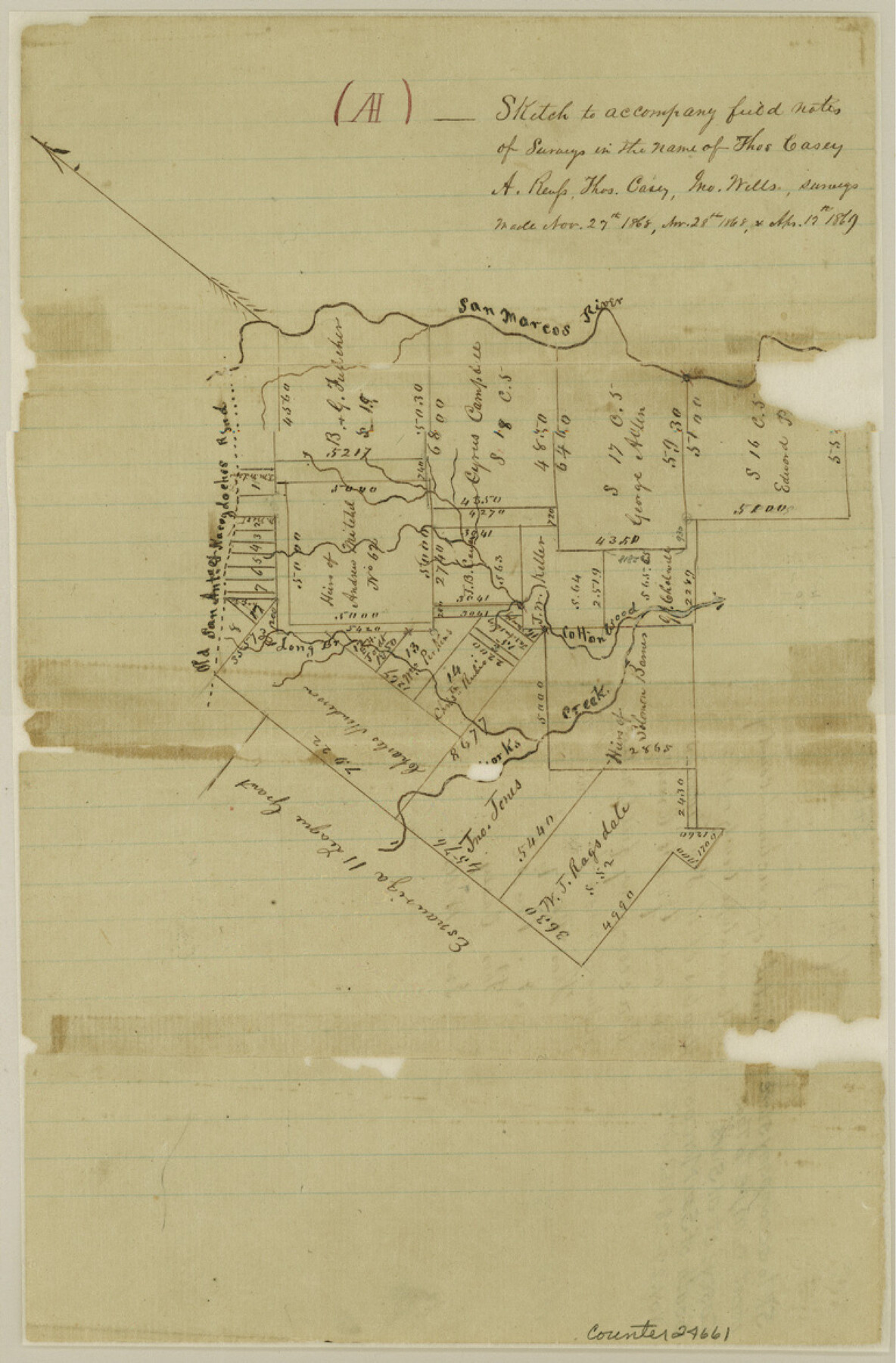
Guadalupe County Sketch File 5a
[Sketch and explanation on waters of San Marcos River and Works Creek]
-
Map/Doc
42205
-
Collection
General Map Collection
-
Object Dates
1869/4/22 (Creation Date)
1869/4/27 (File Date)
1868/11/28 (Survey Date)
1867/4/17 (Survey Date)
-
People and Organizations
A.M. Erskine (Surveyor/Engineer)
-
Counties
Guadalupe Hays
-
Subjects
Surveying Sketch File
-
Height x Width
12.6 x 8.0 inches
32.0 x 20.3 cm
-
Medium
paper, manuscript
-
Features
San Marcos River
Old San Antonio-Nacogdoches Road
Old San Antonio Road
Nacogdoches Road
Cottonwood Creek
Long Branch of York's Creek
York's Creek
Part of: General Map Collection
La Salle County Working Sketch 17

Print $20.00
- Digital $50.00
La Salle County Working Sketch 17
1936
Size 16.7 x 19.9 inches
Map/Doc 70318
Map of the country in the vicinity of San Antonio de Bexar reduced in part from the county map of Bexar with additions by J. Edmd. Blake, 1st Lieut Topl. Engs.

Print $20.00
- Digital $50.00
Map of the country in the vicinity of San Antonio de Bexar reduced in part from the county map of Bexar with additions by J. Edmd. Blake, 1st Lieut Topl. Engs.
1845
Size 18.3 x 26.1 inches
Map/Doc 72720
Crosby County Working Sketch 1

Print $20.00
- Digital $50.00
Crosby County Working Sketch 1
Size 28.0 x 26.0 inches
Map/Doc 68435
[Sketch for Mineral Application 26543 - Sabine River, D. H. Sanford]
![65678, [Sketch for Mineral Application 26543 - Sabine River, D. H. Sanford], General Map Collection](https://historictexasmaps.com/wmedia_w700/maps/65678.tif.jpg)
Print $40.00
- Digital $50.00
[Sketch for Mineral Application 26543 - Sabine River, D. H. Sanford]
1931
Size 73.0 x 30.3 inches
Map/Doc 65678
Duval County Rolled Sketch DCR

Print $40.00
- Digital $50.00
Duval County Rolled Sketch DCR
1931
Size 41.8 x 93.5 inches
Map/Doc 8804
Comanche County Working Sketch 19

Print $20.00
- Digital $50.00
Comanche County Working Sketch 19
1973
Size 28.9 x 40.3 inches
Map/Doc 68153
Jefferson County Working Sketch 9

Print $20.00
- Digital $50.00
Jefferson County Working Sketch 9
1937
Size 19.5 x 22.0 inches
Map/Doc 66552
Parker County Sketch File 44

Print $6.00
- Digital $50.00
Parker County Sketch File 44
1874
Size 11.0 x 13.5 inches
Map/Doc 33608
Val Verde County Working Sketch 34

Print $20.00
- Digital $50.00
Val Verde County Working Sketch 34
1940
Size 33.7 x 27.9 inches
Map/Doc 72169
Newton County Sketch File 22

Print $4.00
- Digital $50.00
Newton County Sketch File 22
1890
Size 14.2 x 8.7 inches
Map/Doc 32401
Uvalde County Working Sketch 57

Print $20.00
- Digital $50.00
Uvalde County Working Sketch 57
1985
Size 38.4 x 43.0 inches
Map/Doc 72127
La Salle County Sketch File 11

Print $20.00
- Digital $50.00
La Salle County Sketch File 11
1877
Size 12.7 x 8.1 inches
Map/Doc 29460
You may also like
Howard County Boundary File 2a

Print $9.00
- Digital $50.00
Howard County Boundary File 2a
Size 14.6 x 11.3 inches
Map/Doc 55118
Kent County Working Sketch 11

Print $20.00
- Digital $50.00
Kent County Working Sketch 11
Size 24.3 x 37.4 inches
Map/Doc 70018
Crockett County Rolled Sketch 56

Print $20.00
- Digital $50.00
Crockett County Rolled Sketch 56
1944
Size 24.2 x 31.1 inches
Map/Doc 5599
PSL Field Notes for Blocks I, O, and X in Hockley and Terry Counties and Blocks A and D in Hockley County

PSL Field Notes for Blocks I, O, and X in Hockley and Terry Counties and Blocks A and D in Hockley County
Map/Doc 81657
Map of Bee County State of Texas

Print $20.00
- Digital $50.00
Map of Bee County State of Texas
1863
Size 31.1 x 25.3 inches
Map/Doc 3286
Right of Way and Track Map International & Gt Northern Ry. operated by the International & Gt. Northern Ry. Co., San Antonio Division

Print $40.00
- Digital $50.00
Right of Way and Track Map International & Gt Northern Ry. operated by the International & Gt. Northern Ry. Co., San Antonio Division
1917
Size 25.5 x 57.3 inches
Map/Doc 64589
Archer County Working Sketch 2

Print $20.00
- Digital $50.00
Archer County Working Sketch 2
1907
Size 19.6 x 18.6 inches
Map/Doc 67142
Liberty County Sketch File 36

Print $2.00
- Digital $50.00
Liberty County Sketch File 36
Size 9.4 x 9.0 inches
Map/Doc 29973
Approaches to Galveston Bay

Print $40.00
- Digital $50.00
Approaches to Galveston Bay
1972
Size 50.2 x 36.0 inches
Map/Doc 69881
Ownership Map Lamb County

Print $20.00
- Digital $50.00
Ownership Map Lamb County
1934
Size 37.6 x 45.0 inches
Map/Doc 89847
Hudspeth County Rolled Sketch 43A

Print $3.00
- Digital $50.00
Hudspeth County Rolled Sketch 43A
1958
Size 10.7 x 8.8 inches
Map/Doc 6252
Stonewall County Sketch File X

Print $20.00
- Digital $50.00
Stonewall County Sketch File X
1901
Size 25.8 x 18.1 inches
Map/Doc 12378