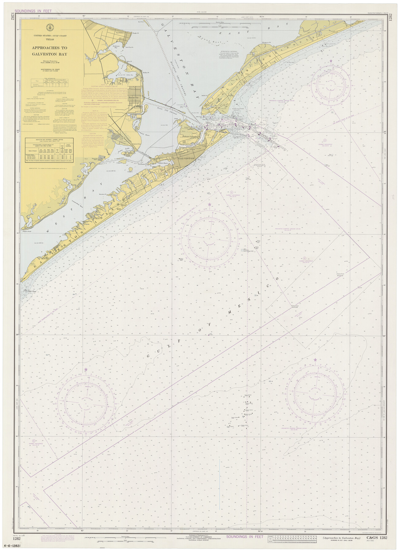
Approaches to Galveston Bay
K-6-1282i
-
Map/Doc
69881
-
Collection
General Map Collection
-
Object Dates
4/8/1972 (Creation Date)
-
Counties
Galveston
-
Subjects
Nautical Charts
-
Height x Width
50.2 x 36.0 inches
127.5 x 91.4 cm
Part of: General Map Collection
Trinity County Sketch File 20

Print $20.00
- Digital $50.00
Trinity County Sketch File 20
Size 21.3 x 27.9 inches
Map/Doc 12485
Jefferson County Working Sketch 41

Print $20.00
- Digital $50.00
Jefferson County Working Sketch 41
1985
Size 26.4 x 20.8 inches
Map/Doc 66585
Comal County Sketch File 6

Print $6.00
- Digital $50.00
Comal County Sketch File 6
Size 10.3 x 8.1 inches
Map/Doc 19008
Gillespie County

Print $40.00
- Digital $50.00
Gillespie County
1887
Size 34.6 x 49.8 inches
Map/Doc 66836
Hutchinson County Rolled Sketch 37

Print $20.00
- Digital $50.00
Hutchinson County Rolled Sketch 37
1950
Size 24.4 x 44.4 inches
Map/Doc 6296
Map of Donley County

Print $20.00
- Digital $50.00
Map of Donley County
1894
Size 44.6 x 35.8 inches
Map/Doc 16823
[Center Line of the Texas and Pacific Railroad Company 16 Mile Reserve]
![3125, [Center Line of the Texas and Pacific Railroad Company 16 Mile Reserve], General Map Collection](https://historictexasmaps.com/wmedia_w700/maps/3125-1.tif.jpg)
Print $40.00
- Digital $50.00
[Center Line of the Texas and Pacific Railroad Company 16 Mile Reserve]
1876
Size 43.1 x 55.6 inches
Map/Doc 3125
Bell County Sketch File 21

Print $4.00
- Digital $50.00
Bell County Sketch File 21
1871
Size 8.0 x 9.7 inches
Map/Doc 14410

Nueces County Rolled Sketch 96

Print $44.00
Nueces County Rolled Sketch 96
1983
Size 24.2 x 36.5 inches
Map/Doc 7053
Real County Working Sketch 87

Print $20.00
- Digital $50.00
Real County Working Sketch 87
1988
Size 30.9 x 29.6 inches
Map/Doc 71979
Montague County Working Sketch 19

Print $20.00
- Digital $50.00
Montague County Working Sketch 19
1952
Size 26.4 x 21.5 inches
Map/Doc 71085
You may also like
Pecos County Rolled Sketch 187

Print $20.00
- Digital $50.00
Pecos County Rolled Sketch 187
1985
Size 17.8 x 22.9 inches
Map/Doc 7306
Howard County Boundary File 4a

Print $60.00
- Digital $50.00
Howard County Boundary File 4a
Size 70.6 x 10.0 inches
Map/Doc 55166
Travis County Working Sketch 15

Print $20.00
- Digital $50.00
Travis County Working Sketch 15
1939
Size 16.1 x 19.7 inches
Map/Doc 69399
Amistad International Reservoir on Rio Grande 83

Print $20.00
- Digital $50.00
Amistad International Reservoir on Rio Grande 83
1949
Size 28.5 x 40.3 inches
Map/Doc 75512
Llano County Working Sketch 12

Print $20.00
- Digital $50.00
Llano County Working Sketch 12
Size 18.8 x 12.5 inches
Map/Doc 70630

[Map showing Jno. H. Gibson Block D]
![92005, [Map showing Jno. H. Gibson Block D], Twichell Survey Records](https://historictexasmaps.com/wmedia_w700/maps/92005-1.tif.jpg)
Print $20.00
- Digital $50.00
[Map showing Jno. H. Gibson Block D]
Size 18.3 x 15.9 inches
Map/Doc 92005
Flight Mission No. DCL-7C, Frame 27, Kenedy County

Print $20.00
- Digital $50.00
Flight Mission No. DCL-7C, Frame 27, Kenedy County
1943
Size 15.4 x 15.2 inches
Map/Doc 86019
Hansford County

Print $20.00
- Digital $50.00
Hansford County
1902
Size 42.3 x 37.5 inches
Map/Doc 4969
Marion County Boundary File 2

Print $6.00
- Digital $50.00
Marion County Boundary File 2
Size 11.2 x 8.7 inches
Map/Doc 56818
Flight Mission No. DQN-5K, Frame 50, Calhoun County

Print $20.00
- Digital $50.00
Flight Mission No. DQN-5K, Frame 50, Calhoun County
1953
Size 18.5 x 22.3 inches
Map/Doc 84395
Brewster County Working Sketch Graphic Index, East Part, Sheet 1 (Sketches 1 to 111)

Print $20.00
- Digital $50.00
Brewster County Working Sketch Graphic Index, East Part, Sheet 1 (Sketches 1 to 111)
1952
Size 47.4 x 29.6 inches
Map/Doc 76476