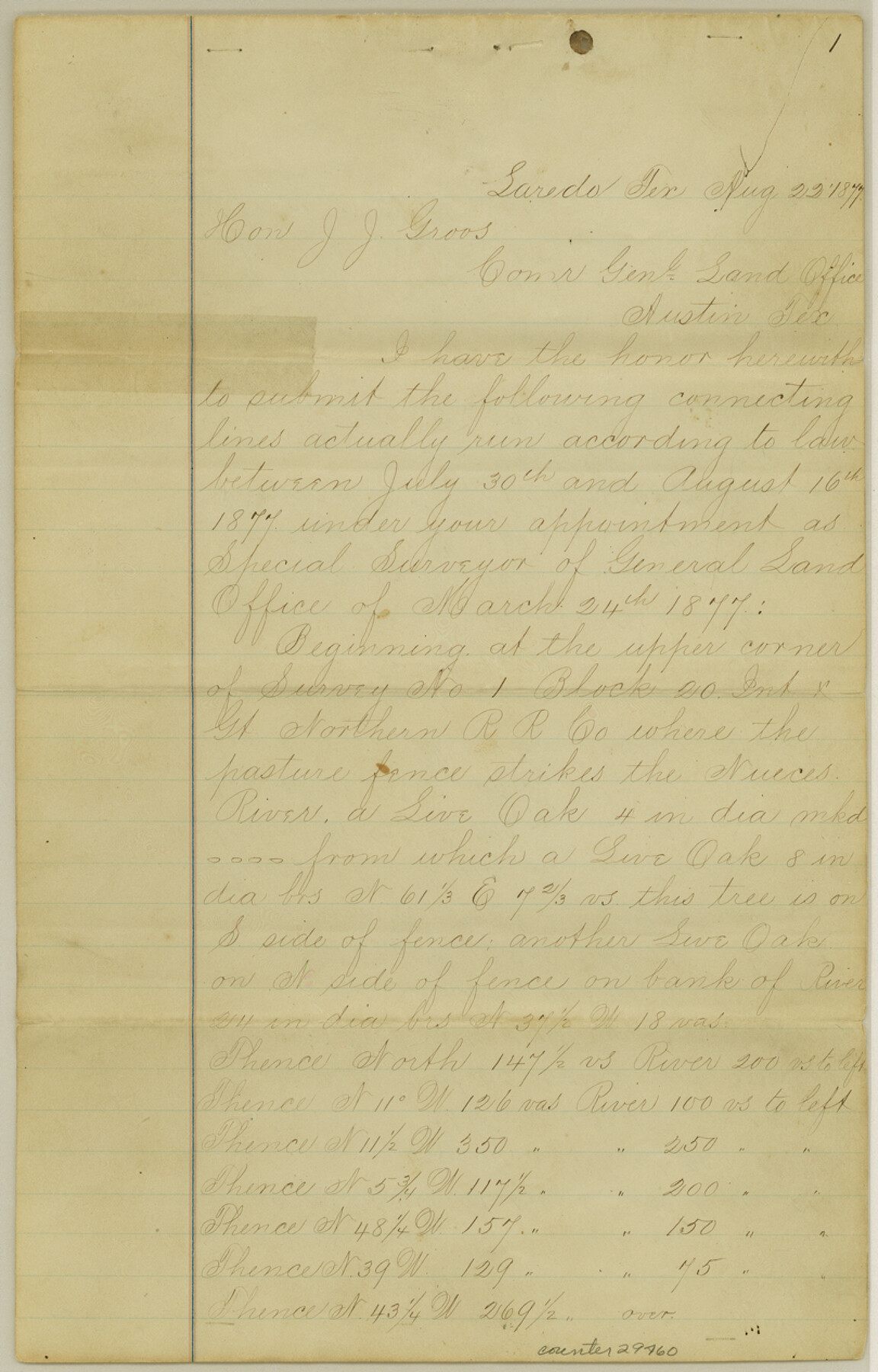
La Salle County Sketch File 11
[Connecting line from upper corner of 1, Block 20, I. & G. N. RR. Co.]
-
Map/Doc
29460
-
Collection
General Map Collection
-
Object Dates
1877/8/22 (Creation Date)
1877/8/28 (File Date)
1877/8/22 (Correspondence Date)
1877/7/30 (Survey Date)
1877/8/16 (Survey Date)
-
People and Organizations
A. Wyschetzki (Surveyor/Engineer)
-
Counties
La Salle
-
Subjects
Surveying Sketch File
-
Height x Width
12.7 x 8.1 inches
32.3 x 20.6 cm
-
Medium
paper, manuscript
-
Features
Nueces River
Bayouka River
Pumpkin Creek
Mustang Creek
Salado Creek
Cochina to San Antonio Road
Espio Creek
Anderson's Creek
Galvana Creek
Dr. Speer's Ranch
Sugar Creek
Loma Vista Creek
Old San Antonio to Presidio Road
Leona River
Part of: General Map Collection
Flight Mission No. BRE-4P, Frame 171, Nueces County

Print $20.00
- Digital $50.00
Flight Mission No. BRE-4P, Frame 171, Nueces County
1956
Size 18.6 x 22.5 inches
Map/Doc 86834
Flight Mission No. CRC-3R, Frame 17, Chambers County

Print $20.00
- Digital $50.00
Flight Mission No. CRC-3R, Frame 17, Chambers County
1956
Size 18.6 x 22.2 inches
Map/Doc 84791
Webb County Working Sketch 95

Print $20.00
- Digital $50.00
Webb County Working Sketch 95
1991
Size 16.6 x 42.2 inches
Map/Doc 72462
Collin County Sketch File 12

Print $40.00
- Digital $50.00
Collin County Sketch File 12
1851
Size 24.3 x 31.3 inches
Map/Doc 11127

Leon County Rolled Sketch 7

Print $40.00
- Digital $50.00
Leon County Rolled Sketch 7
1954
Size 55.9 x 35.0 inches
Map/Doc 9428
Flight Mission No. DCL-5C, Frame 73, Kenedy County

Print $20.00
- Digital $50.00
Flight Mission No. DCL-5C, Frame 73, Kenedy County
1943
Size 18.5 x 22.2 inches
Map/Doc 85856
Bryant's Railroad Guide, the Tourists' and Emigrants' Hand-book of Travel

Print $260.00
- Digital $50.00
Bryant's Railroad Guide, the Tourists' and Emigrants' Hand-book of Travel
1875
Size 9.3 x 6.0 inches
Map/Doc 93627
Bee County Working Sketch 21

Print $20.00
- Digital $50.00
Bee County Working Sketch 21
1983
Size 32.5 x 37.5 inches
Map/Doc 67271
Flight Mission No. DIX-10P, Frame 149, Aransas County

Print $20.00
- Digital $50.00
Flight Mission No. DIX-10P, Frame 149, Aransas County
1956
Size 18.6 x 22.3 inches
Map/Doc 83951
San Augustine County Working Sketch 1

Print $3.00
- Digital $50.00
San Augustine County Working Sketch 1
1906
Size 9.1 x 11.3 inches
Map/Doc 63688
Lampasas County Sketch File 14

Print $6.00
- Digital $50.00
Lampasas County Sketch File 14
Size 16.2 x 10.5 inches
Map/Doc 29426
You may also like
Navigation Maps of Gulf Intracoastal Waterway, Port Arthur to Brownsville, Texas

Print $4.00
- Digital $50.00
Navigation Maps of Gulf Intracoastal Waterway, Port Arthur to Brownsville, Texas
1951
Size 16.7 x 21.5 inches
Map/Doc 65434
Pecos County Working Sketch 20

Print $20.00
- Digital $50.00
Pecos County Working Sketch 20
1918
Size 33.0 x 23.2 inches
Map/Doc 71490
Val Verde County Working Sketch 66

Print $20.00
- Digital $50.00
Val Verde County Working Sketch 66
1964
Size 42.1 x 46.9 inches
Map/Doc 72201
Gregg County Rolled Sketch JB2

Print $20.00
- Digital $50.00
Gregg County Rolled Sketch JB2
1933
Size 42.0 x 35.1 inches
Map/Doc 8341
Flight Mission No. BRA-8M, Frame 68, Jefferson County

Print $20.00
- Digital $50.00
Flight Mission No. BRA-8M, Frame 68, Jefferson County
1953
Size 18.6 x 22.4 inches
Map/Doc 85588
Calhoun County NRC Article 33.136 Sketch 12

Print $24.00
Calhoun County NRC Article 33.136 Sketch 12
2023
Map/Doc 97271
Val Verde County Sketch File Z16

Print $20.00
- Digital $50.00
Val Verde County Sketch File Z16
1905
Size 21.4 x 20.9 inches
Map/Doc 12557
[Part of T. & N. O. RR. Co Block 2 and area around Jasper Hays survey]
![90850, [Part of T. & N. O. RR. Co Block 2 and area around Jasper Hays survey], Twichell Survey Records](https://historictexasmaps.com/wmedia_w700/maps/90850-2.tif.jpg)
Print $20.00
- Digital $50.00
[Part of T. & N. O. RR. Co Block 2 and area around Jasper Hays survey]
1907
Size 13.3 x 28.4 inches
Map/Doc 90850
Myrick Farms Lubbock & Hockley Counties

Print $20.00
- Digital $50.00
Myrick Farms Lubbock & Hockley Counties
Size 21.3 x 21.5 inches
Map/Doc 92830
Sketch showing progress of topographical work Laguna Madre and vicinity from Rainey Is. to Baffins Bay, Coast of Texas Sect. IX [and accompanying letter]
![72958, Sketch showing progress of topographical work Laguna Madre and vicinity from Rainey Is. to Baffins Bay, Coast of Texas Sect. IX [and accompanying letter], General Map Collection](https://historictexasmaps.com/wmedia_w700/maps/72958.tif.jpg)
Print $2.00
- Digital $50.00
Sketch showing progress of topographical work Laguna Madre and vicinity from Rainey Is. to Baffins Bay, Coast of Texas Sect. IX [and accompanying letter]
1881
Size 11.2 x 8.8 inches
Map/Doc 72958
Haskell County

Print $20.00
- Digital $50.00
Haskell County
1933
Size 41.7 x 36.2 inches
Map/Doc 77307
Jones County Sketch File 11a

Print $40.00
- Digital $50.00
Jones County Sketch File 11a
Size 37.5 x 49.5 inches
Map/Doc 10510