Gregg County Rolled Sketch JB2
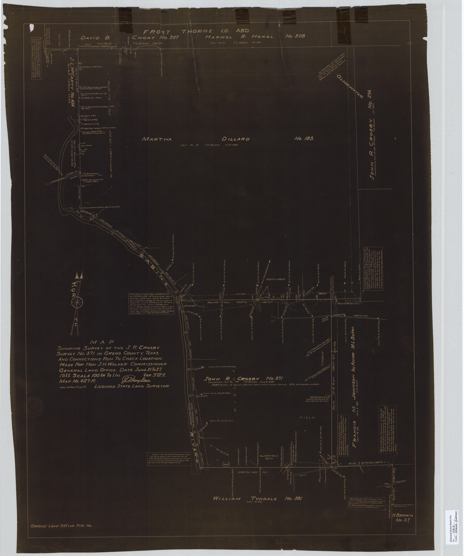
Map showing the survey of the J.R. Crosby survey no. 371 in Gregg County, Texas and connections run to check location
-
Map/Doc
8341
-
Collection
General Map Collection
-
Object Dates
1933/6/27 (Creation Date)
-
People and Organizations
J.S. Boyles (Surveyor/Engineer)
-
Counties
Gregg
-
Subjects
Surveying Rolled Sketch
-
Height x Width
42.0 x 35.1 inches
106.7 x 89.2 cm
-
Medium
blueprint/diazo
-
Scale
1' = 100 varas
-
Comments
See Gregg County Sketch File 11 (24591) for report.
Related maps
Gregg County Sketch File 11

Print $12.00
- Digital $50.00
Gregg County Sketch File 11
1933
Size 14.4 x 8.9 inches
Map/Doc 24591
Part of: General Map Collection
Hudspeth County Rolled Sketch 75

Print $40.00
- Digital $50.00
Hudspeth County Rolled Sketch 75
1992
Size 35.6 x 48.9 inches
Map/Doc 9238
Reagan County Boundary File 1a

Print $50.00
- Digital $50.00
Reagan County Boundary File 1a
Size 14.4 x 8.7 inches
Map/Doc 58154
Leon County Rolled Sketch 18

Print $20.00
- Digital $50.00
Leon County Rolled Sketch 18
1982
Size 33.1 x 34.8 inches
Map/Doc 6604
Presidio County Sketch File 122

Print $22.00
- Digital $50.00
Presidio County Sketch File 122
2010
Size 11.0 x 8.5 inches
Map/Doc 89604
[Map of Chicago, Rock Island & Texas Railway through Tarrant County, Texas]
![64412, [Map of Chicago, Rock Island & Texas Railway through Tarrant County, Texas], General Map Collection](https://historictexasmaps.com/wmedia_w700/maps/64412.tif.jpg)
Print $40.00
- Digital $50.00
[Map of Chicago, Rock Island & Texas Railway through Tarrant County, Texas]
1893
Size 22.9 x 122.0 inches
Map/Doc 64412
Val Verde County Sketch File 39

Print $20.00
- Digital $50.00
Val Verde County Sketch File 39
1939
Size 32.0 x 16.2 inches
Map/Doc 12581
Dimmit County Sketch File 59

Print $26.00
- Digital $50.00
Dimmit County Sketch File 59
1912
Size 14.4 x 8.9 inches
Map/Doc 21193
Jasper County Sketch File 6

Print $26.00
- Digital $50.00
Jasper County Sketch File 6
1867
Size 12.8 x 8.2 inches
Map/Doc 27771
Flight Mission No. DQN-1K, Frame 108, Calhoun County

Print $20.00
- Digital $50.00
Flight Mission No. DQN-1K, Frame 108, Calhoun County
1953
Size 18.4 x 22.1 inches
Map/Doc 84175
Milam County Working Sketch 11

Print $20.00
- Digital $50.00
Milam County Working Sketch 11
1987
Size 43.8 x 31.9 inches
Map/Doc 71026
Armstrong County Sketch File A-7

Print $40.00
- Digital $50.00
Armstrong County Sketch File A-7
Size 15.0 x 20.4 inches
Map/Doc 10848
Dimmit County Sketch File 48

Print $20.00
- Digital $50.00
Dimmit County Sketch File 48
1909
Size 17.9 x 19.3 inches
Map/Doc 11357
You may also like
Bailey County Sketch File B

Print $40.00
- Digital $50.00
Bailey County Sketch File B
Size 14.5 x 20.4 inches
Map/Doc 10891
Robertson Co.

Print $20.00
- Digital $50.00
Robertson Co.
1945
Size 46.3 x 37.2 inches
Map/Doc 77409
Bailey County Sketch File 17

Print $12.00
- Digital $50.00
Bailey County Sketch File 17
Size 10.9 x 7.4 inches
Map/Doc 13980
Corpus Christi Harbor

Print $40.00
- Digital $50.00
Corpus Christi Harbor
1975
Size 37.6 x 51.5 inches
Map/Doc 73479
Roswell District, New Mexico

Print $40.00
- Digital $50.00
Roswell District, New Mexico
Size 40.7 x 57.6 inches
Map/Doc 89817
Pecos County Sketch File 49c

Print $10.00
- Digital $50.00
Pecos County Sketch File 49c
Size 5.9 x 8.7 inches
Map/Doc 33768
Hudspeth County Sketch File 15

Print $9.00
- Digital $50.00
Hudspeth County Sketch File 15
1927
Size 14.3 x 8.8 inches
Map/Doc 26944
Austin County Working Sketch Graphic Index

Print $20.00
- Digital $50.00
Austin County Working Sketch Graphic Index
1943
Size 38.6 x 41.1 inches
Map/Doc 76459
Runnels County

Print $20.00
- Digital $50.00
Runnels County
1948
Size 46.5 x 36.4 inches
Map/Doc 77411
Ector County Rolled Sketch 9

Print $20.00
- Digital $50.00
Ector County Rolled Sketch 9
1940
Size 39.1 x 43.0 inches
Map/Doc 8837
San Augustine Co.

Print $20.00
- Digital $50.00
San Augustine Co.
1949
Size 47.9 x 31.2 inches
Map/Doc 73281
