Bailey County Sketch File 17
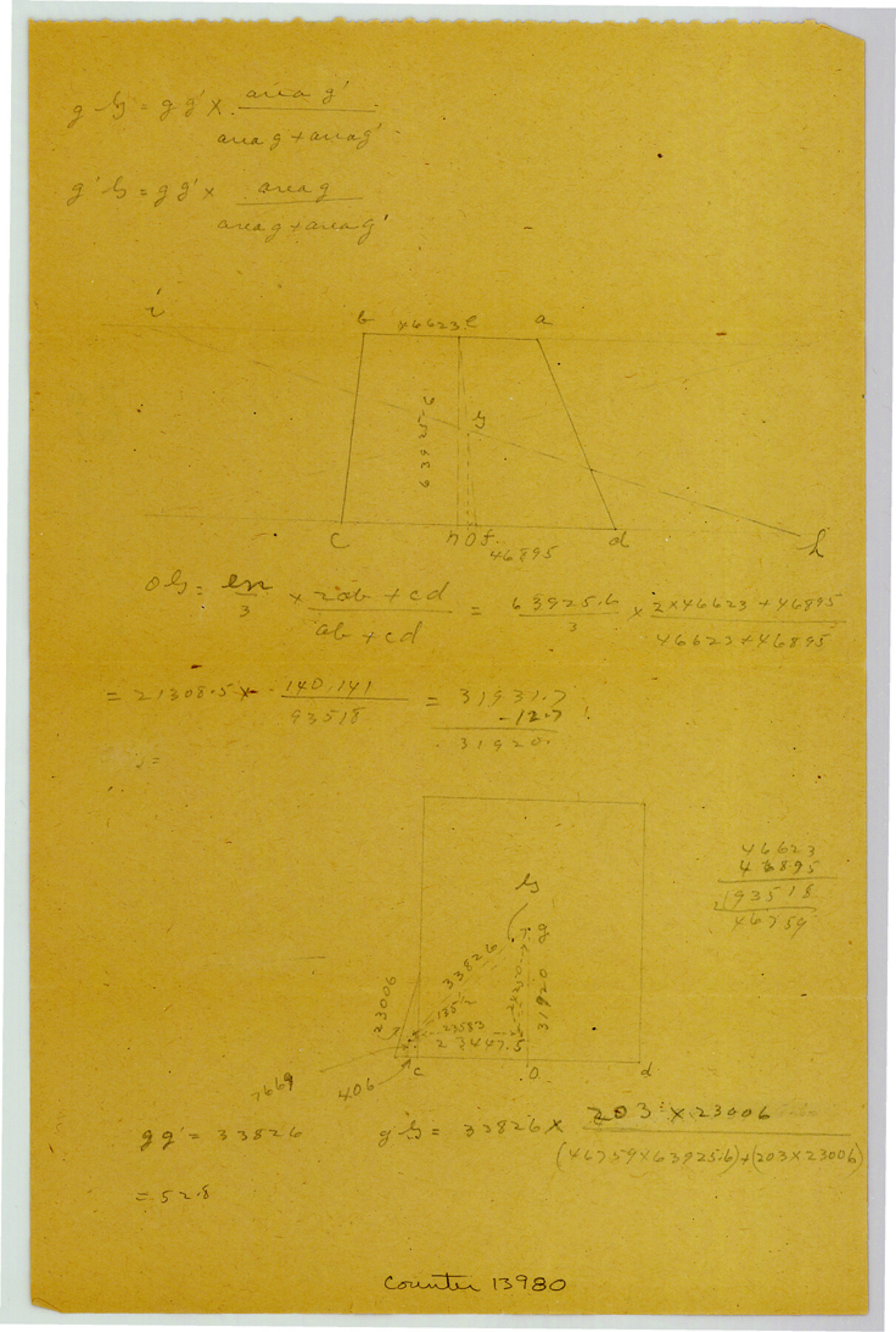
[Computations to determine the geographical center of Bailey County]
-
Map/Doc
13980
-
Collection
General Map Collection
-
Counties
Bailey
-
Subjects
Surveying Sketch File
-
Height x Width
10.9 x 7.4 inches
27.7 x 18.8 cm
-
Medium
paper, manuscript
Part of: General Map Collection
Brewster County Rolled Sketch 46

Print $20.00
- Digital $50.00
Brewster County Rolled Sketch 46
Size 20.8 x 32.2 inches
Map/Doc 5222
Gaines County Sketch File 22

Print $20.00
- Digital $50.00
Gaines County Sketch File 22
1962
Size 18.1 x 23.4 inches
Map/Doc 11528
Knox County Rolled Sketch 19

Print $20.00
- Digital $50.00
Knox County Rolled Sketch 19
1952
Size 27.3 x 24.9 inches
Map/Doc 6559
Flight Mission No. BQR-9K, Frame 44, Brazoria County

Print $20.00
- Digital $50.00
Flight Mission No. BQR-9K, Frame 44, Brazoria County
1952
Size 18.7 x 22.3 inches
Map/Doc 84048
Lubbock County Working Sketch 5

Print $20.00
- Digital $50.00
Lubbock County Working Sketch 5
1950
Size 14.3 x 31.0 inches
Map/Doc 70665
Map of the State of Texas

Print $40.00
- Digital $50.00
Map of the State of Texas
1879
Size 102.3 x 106.1 inches
Map/Doc 16974
Flight Mission No. BRA-8M, Frame 143, Jefferson County

Print $20.00
- Digital $50.00
Flight Mission No. BRA-8M, Frame 143, Jefferson County
1953
Size 18.9 x 22.5 inches
Map/Doc 85635
Bowie County Working Sketch 25

Print $20.00
- Digital $50.00
Bowie County Working Sketch 25
1977
Size 20.5 x 33.9 inches
Map/Doc 67429
Angelina County Sketch File 11f

Print $4.00
- Digital $50.00
Angelina County Sketch File 11f
1885
Size 8.2 x 12.6 inches
Map/Doc 12954
Crosby County Working Sketch 11

Print $20.00
- Digital $50.00
Crosby County Working Sketch 11
1947
Size 23.7 x 22.8 inches
Map/Doc 68445
Reagan County Rolled Sketch 4

Print $20.00
- Digital $50.00
Reagan County Rolled Sketch 4
1928
Size 25.4 x 27.4 inches
Map/Doc 7433

You may also like
Nueces County Sketch File 5

Print $4.00
- Digital $50.00
Nueces County Sketch File 5
Size 8.1 x 11.0 inches
Map/Doc 32507
Map of Panola County

Print $20.00
- Digital $50.00
Map of Panola County
1897
Size 39.5 x 39.1 inches
Map/Doc 66967
Henderson County Sketch File 6

Print $4.00
- Digital $50.00
Henderson County Sketch File 6
1857
Size 10.0 x 8.1 inches
Map/Doc 26327
Henderson County Boundary File 3c

Print $40.00
- Digital $50.00
Henderson County Boundary File 3c
Size 22.5 x 80.6 inches
Map/Doc 54707
Stonewall County Sketch File 26

Print $20.00
- Digital $50.00
Stonewall County Sketch File 26
1953
Size 35.7 x 36.8 inches
Map/Doc 10376
Kent County Rolled Sketch 6

Print $20.00
- Digital $50.00
Kent County Rolled Sketch 6
Size 39.0 x 36.5 inches
Map/Doc 6476
Dimmit County Working Sketch 47

Print $40.00
- Digital $50.00
Dimmit County Working Sketch 47
1980
Size 71.3 x 43.8 inches
Map/Doc 68708
Flight Mission No. BRA-7M, Frame 192, Jefferson County

Print $20.00
- Digital $50.00
Flight Mission No. BRA-7M, Frame 192, Jefferson County
1953
Size 18.5 x 22.4 inches
Map/Doc 85560
Van Zandt County Sketch File 28

Print $4.00
- Digital $50.00
Van Zandt County Sketch File 28
1859
Size 12.5 x 8.2 inches
Map/Doc 39451
Cameron County Rolled Sketch 13

Print $40.00
- Digital $50.00
Cameron County Rolled Sketch 13
1952
Size 37.7 x 62.7 inches
Map/Doc 61787
McMullen County Working Sketch 45

Print $20.00
- Digital $50.00
McMullen County Working Sketch 45
1981
Size 47.6 x 38.5 inches
Map/Doc 70746
McLennan County Sketch File 27

Print $4.00
- Digital $50.00
McLennan County Sketch File 27
Size 8.2 x 8.3 inches
Map/Doc 31300